Predicting geohazard runout is critical for protecting lives, infrastructure and ecosystems. Rapid mass flows, including landslides and avalanches, cause several thousand deaths across a wide range of environments, often travelling many kilometres from their source. The wide range of source conditions and material properties governing these flows makes their runout difficult to anticipate, particularly for downstream communities that may be suddenly exposed to severe impacts. Accurately predicting runout at scale requires models that are both physically realistic and computationally efficient, yet existing approaches face a fundamental speed-realism trade-off. Here we train a machine learning model to predict geohazard runout across representative real-world terrains. The model predicts both flow extent and deposit thickness with high accuracy and 10 2 -10 4 × faster computation than numerical solvers. It is trained over 10 5 numerical simulations across 10 4 real-world digital elevation model chips and reproduces key physical behaviours, including avulsion and deposition patterns, while generalizing across different flow types, sizes and landscapes. Our results demonstrate that neural emulation enables rapid, spatially resolved runout prediction across diverse real-world terrains, opening new opportunities for disaster risk reduction and impact-based forecasting. These results highlight neural emulation as
a promising pathway for extending physically realistic geohazard modelling to spatial and temporal scales relevant for large-scale early-warning systems.
Rapid geophysical flows such as landslides, avalanches, and volcanic flows are among the most destructive natural hazards on Earth [1][2][3][4]. Climate change is increasing the frequency and intensity of extreme precipitation, snowmelt, and storm events, modifying the likelihood of many rapid mass movements [5]. At the same time, accelerating urbanization and infrastructure expansion are increasing exposure to these hazards [6]. These flows can travel many kilometres from their initiation zone, threatening lives, infrastructure, and ecosystems [7]. Predicting how far they will flow, their runout, is central to hazard assessment, land-use planning, and impact-based forecasting. Runout defines the true impact zone and determines the magnitude of damage once failure occurs. Recent analyses suggest that landslides alone affect more than 17% of the world’s land area, with roughly 8% of the global population living within potential runout zones [8]. Yet anticipating the mobility and spatial footprint of these flows remains challenging, particularly when forecasts are needed fast enough to support operational decisions [9].
In forecasting and hazard assessment systems, this computational delay is critical: emergency agencies need runout estimates quickly enough to guide evacuations and prioritise response, not hours after a triggering event [10]. The need for speed becomes even more acute at regional scales, where thousands of potential initiation zones must be screened rapidly before or during intense rainfall or following an earthquake. These time constraints also restrict our ability to generate probabilistic forecasts from large ensembles, which is an essential component of robust, uncertainty-aware decisionmaking during hazardous events [11,12].
Existing runout models fall into two broad classes, each with inherent trade-offs. Empirical and analytical approaches use geometric correlations to estimate runout length or area rapidly, but they neglect the physics of flow motion and cannot reproduce key behaviours such as avulsion or deposition [13]. Physics-based numerical models (e.g., VolcFlow [14], and r.avaflow [15]) resolve depth, velocity, and impact pressure, offering physically realistic insights into flow dynamics. However, they are computationally intensive, even requiring hours for a single simulation, and depend on poorly constrained inputs such as rheology and initial conditions [13]. As a result, their use is largely restricted to retrospective, site-specific studies. Statistical emulators exist but are generally limited to basin-scale applications [16]. At regional or global scales, this speed-realism trade-off prevents large ensemble analyses and limits our ability to propagate uncertainty [17] and provide probabilistic predictions, critical requirements for operational risk assessment and forecasting systems [18].
Here we present a physics-based data-driven framework that bridges the divide between empirical speed and physical realism in geohazard runout prediction. We develop a neural emulator trained on tens of thousands of physics-based simulations to reproduce flow runout across diverse real-world terrains and material properties. The model predicts flow extent and deposit thickness with high accuracy while operating up to four orders of magnitude faster than conventional solvers. Our results demonstrate that spatially constrained, gravity-driven mass flows can be emulated universally across varied landscapes and rheologies. This work lays the groundwork for real-time, physically grounded hazard forecasting and provides a foundation for future multi-hazard extensions.
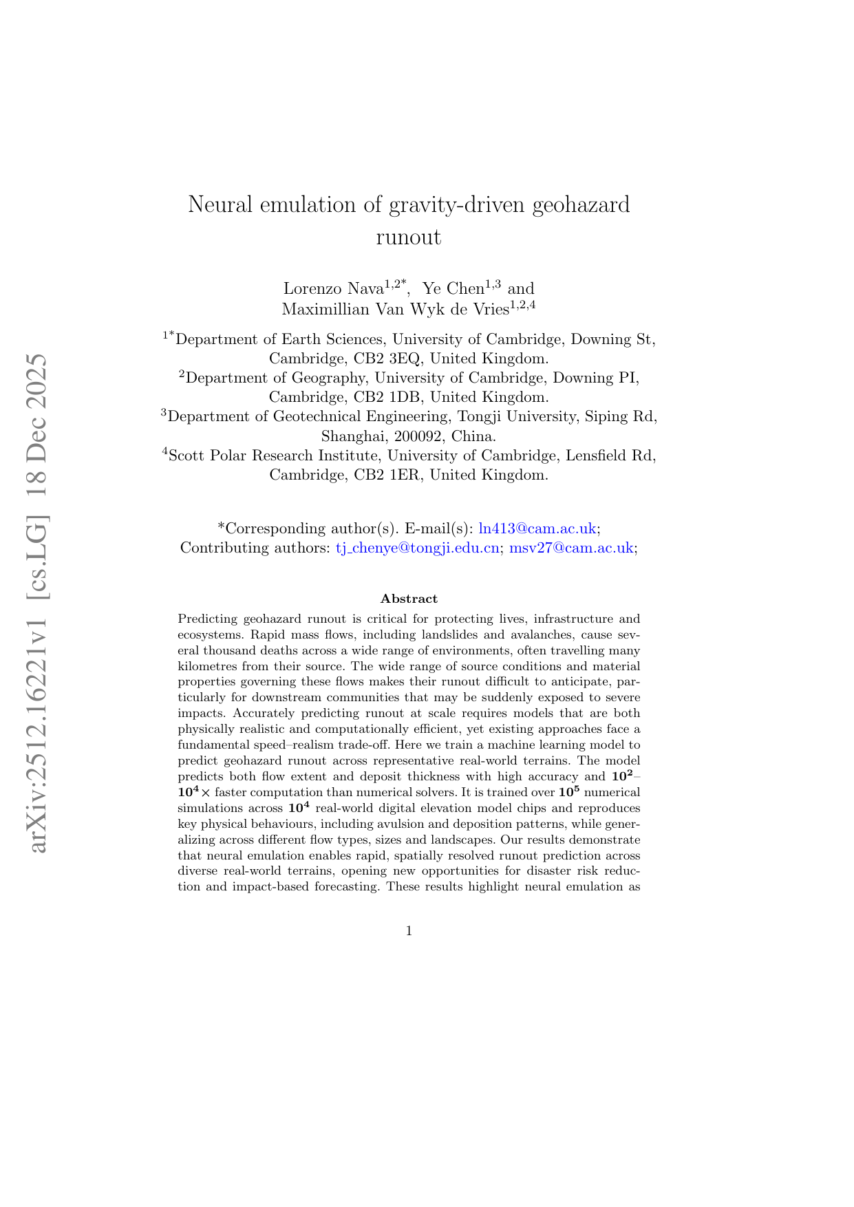
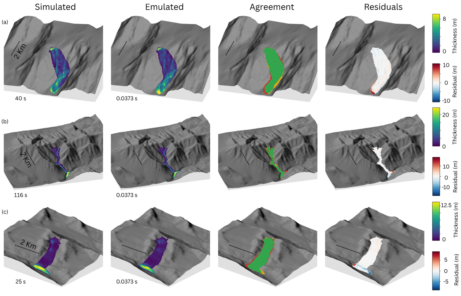
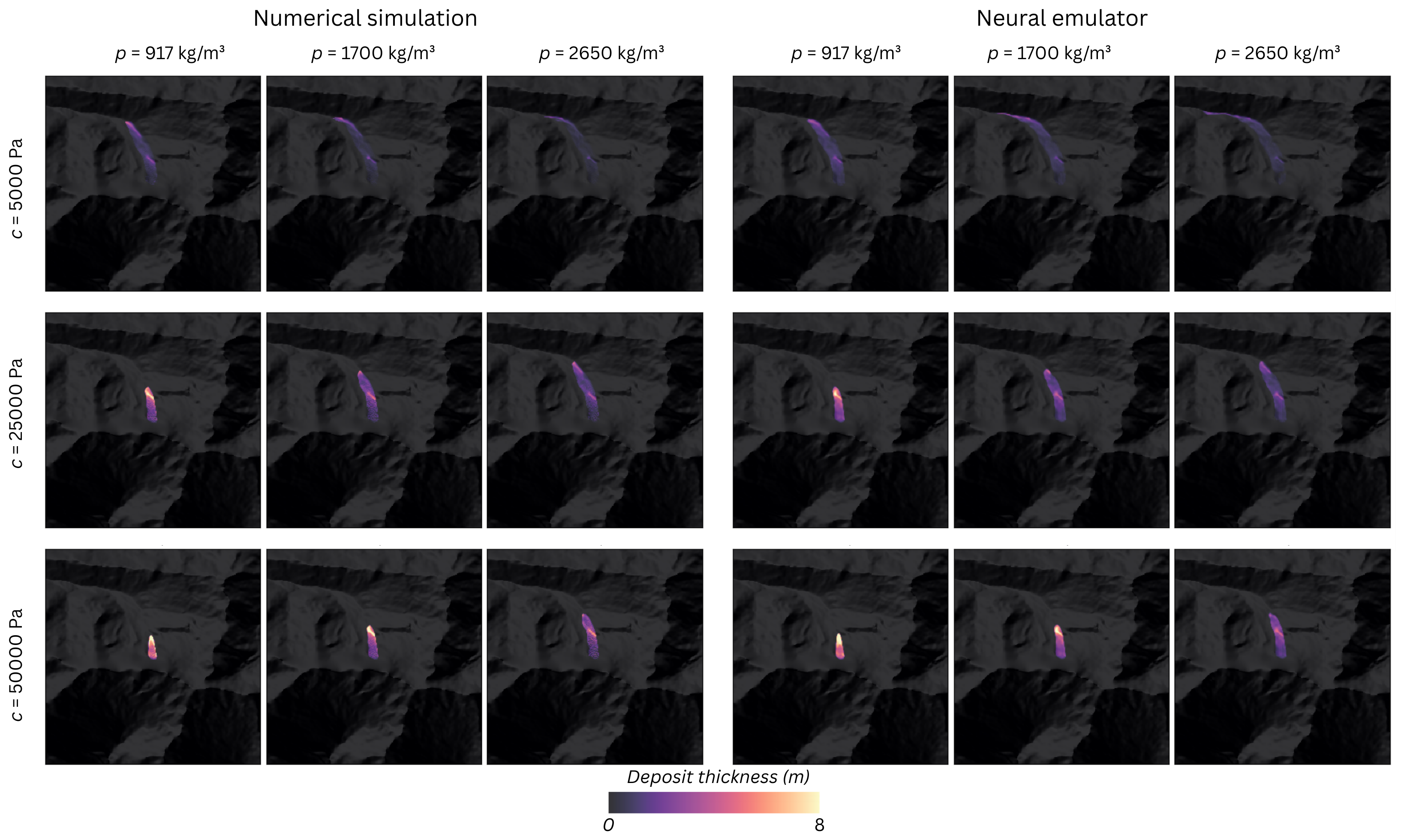
We model the behaviour of rapid, gravity-driven mass flows, such as landslides, and avalanches, using a neural network trained on physics-based numerical simulations. Each simulation initializes a Gaussian-shaped pile of material on a 30 m Copernicus Global Digital Elevation Model (COP30) tile and evolves it downslope under gravity using a depth-averaged [14], frictional rheology [19]. The reference numerical model solves the depth-averaged mass-and momentum-conservation equations with a turbulent basal friction law (Voellmy model) and variable material properties (more details in Section 1.2). Bulk density (ρ) ranges from 917 to 2650 kg m -3 , cohesion (c) from 5 to 50 kPa, and initial volume (V ) from 10 4 to 10 7 m 3 , spanning the transition from ice-rich to rock-dominated materials and from small to large-scale events.
Each simulation produces two target maps: the final runout footprint and the spatial distribution of deposit thickness. We treat the numerical solver as the physical reference and evaluate whether a neural network can reproduce these outputs directly from real topography and bulk flow parameters, generalizing across diverse terrains worldwide.
Formal
This content is AI-processed based on open access ArXiv data.