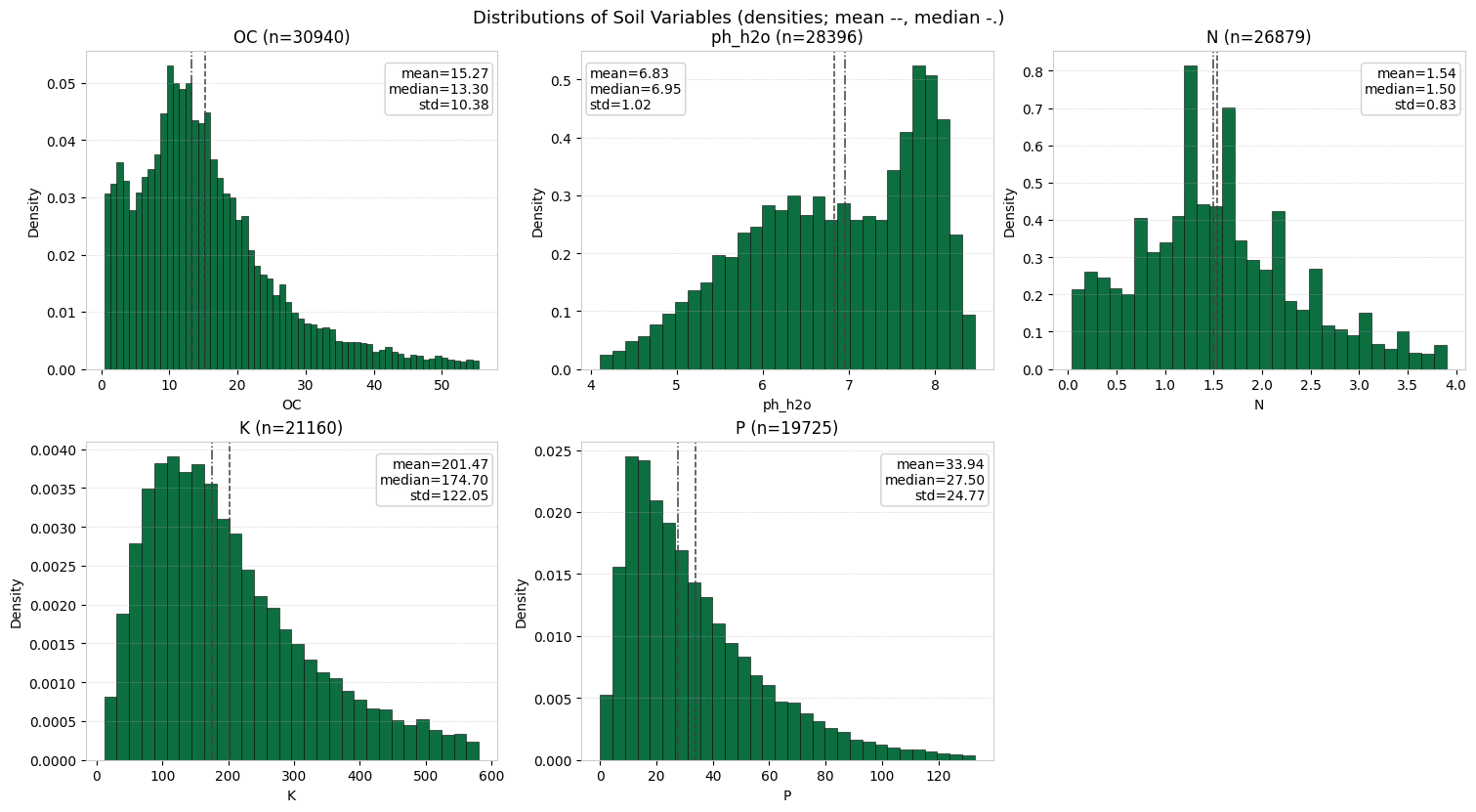
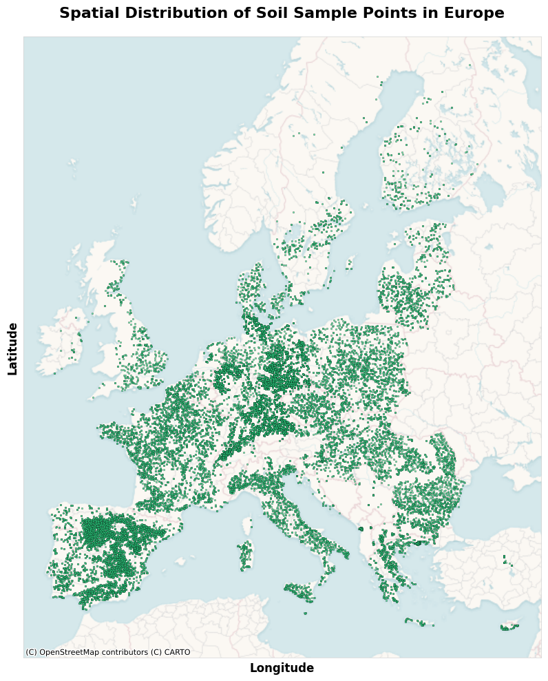
Environmental variables are increasingly affecting agricultural decision-making, yet accessible and scalable tools for soil assessment remain limited. This study presents a robust and scalable modeling system for estimating soil properties in croplands, including soil organic carbon (SOC), total nitrogen (N), available phosphorus (P), exchangeable potassium (K), and pH, using remote sensing data and environmental covariates. The system employs a hybrid modeling approach, combining the indirect methods of modeling soil through proxies and drivers with direct spectral modeling. We extend current approaches by using interpretable physics-informed covariates derived from radiative transfer models (RTMs) and complex, nonlinear embeddings from a foundation model. We validate the system on a harmonized dataset that covers Europes cropland soils across diverse pedoclimatic zones. Evaluation is conducted under a robust validation framework that enforces strict spatial blocking, stratified splits, and statistically distinct train-test sets, which deliberately make the evaluation harder and produce more realistic error estimates for unseen regions. The models achieved their highest accuracy for SOC and N. This performance held across unseen locations, under both spatial cross-validation and an independent test set. SOC obtained a MAE of 5.12 g/kg and a CCC of 0.77, and N obtained a MAE of 0.44 g/kg and a CCC of 0.77. We also assess uncertainty through conformal calibration, achieving 90 percent coverage at the target confidence level. This study contributes to the digital advancement of agriculture through the application of scalable, data-driven soil analysis frameworks that can be extended to related domains requiring quantitative soil evaluation, such as carbon markets.
Agriculture is the foundation of global food security, with soil as a key resource for production [1]. In the 21st century, agriculture continues to rely mainly on traditional practices with comparatively low levels of digitalization [2]. This limited digitalization is particularly concerning given the increasing challenges the sector faces. Global food demand is projected to increase by 35-56% by 2050 relative to 2010, making future production more difficult to meet under land and climate constraints [3,4]. Across major crops, yield growth has stagnated under climate variability [5][6][7]. Agriculture, forestry, and other land use account for ∼13-21% of anthropogenic greenhouse gas emissions, and soil degradation is widespread, with an estimated one-third of global soils moderately to severely degraded [8][9][10]. In particular, nutrient depletion and declines in soil organic matter reduce soil fertility, water-holding capacity, and aggregate stability, thereby affecting long-term productivity and resilience [11]. Addressing these challenges requires agricultural systems to simultaneously increase productivity, maintain farmer profitability, and reduce negative environmental impacts. Achieving this "triple challenge" depends on more efficient input management.
Fertilizers, in particular, represent one of the highest operational costs for farms and are essential to sustaining yields [12]. Recent isotopic tracing studies report 21-44% of applied nitrogen fertilizer is taken up by crops, with the remainder being lost to leaching, volatilization, or denitrification [13,14]. These inefficiencies impose economic losses, degrade soil health, and contribute to greenhouse gas emissions. Soil sampling remains the conventional method for fertilizer planning, but adoption is constrained by cost, time, and logistical barriers [15]. Although precision agriculture technologies exist, their uptake remains limited due to high costs, technical complexity, and gaps in spatial data coverage [16,17].
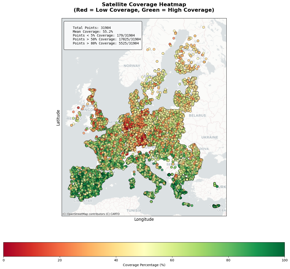
Recent policy developments further highlight the urgency of scalable soil monitoring. The European Union’s Soil Monitoring Law establishes a harmonized framework to evaluate soil health across member states, with indicators such as the SOC-to-clay ratio [18]. As more than 60% of EU soils are classified as unhealthy, scalable approaches are required to generate timely and field-specific soil data to support both farm productivity and environmental sustainability [19,20]. However, monitoring soil health at scale is not trivial. Remote sensing provides proxies for soil conditions, but direct detection of most soil chemical properties remains constrained by vegetation cover, shallow penetration, and low signal-to-noise ratios in relevant spectral domains [21][22][23]. Even in bare-soil conditions, reflectance is typically limited to the uppermost soil layer [24]. Unlike broad trend analyses for agronomic decision-making, robust systems require harmonized ground truth, transparent validation, and explicit uncertainty estimates to ensure practical reliability.
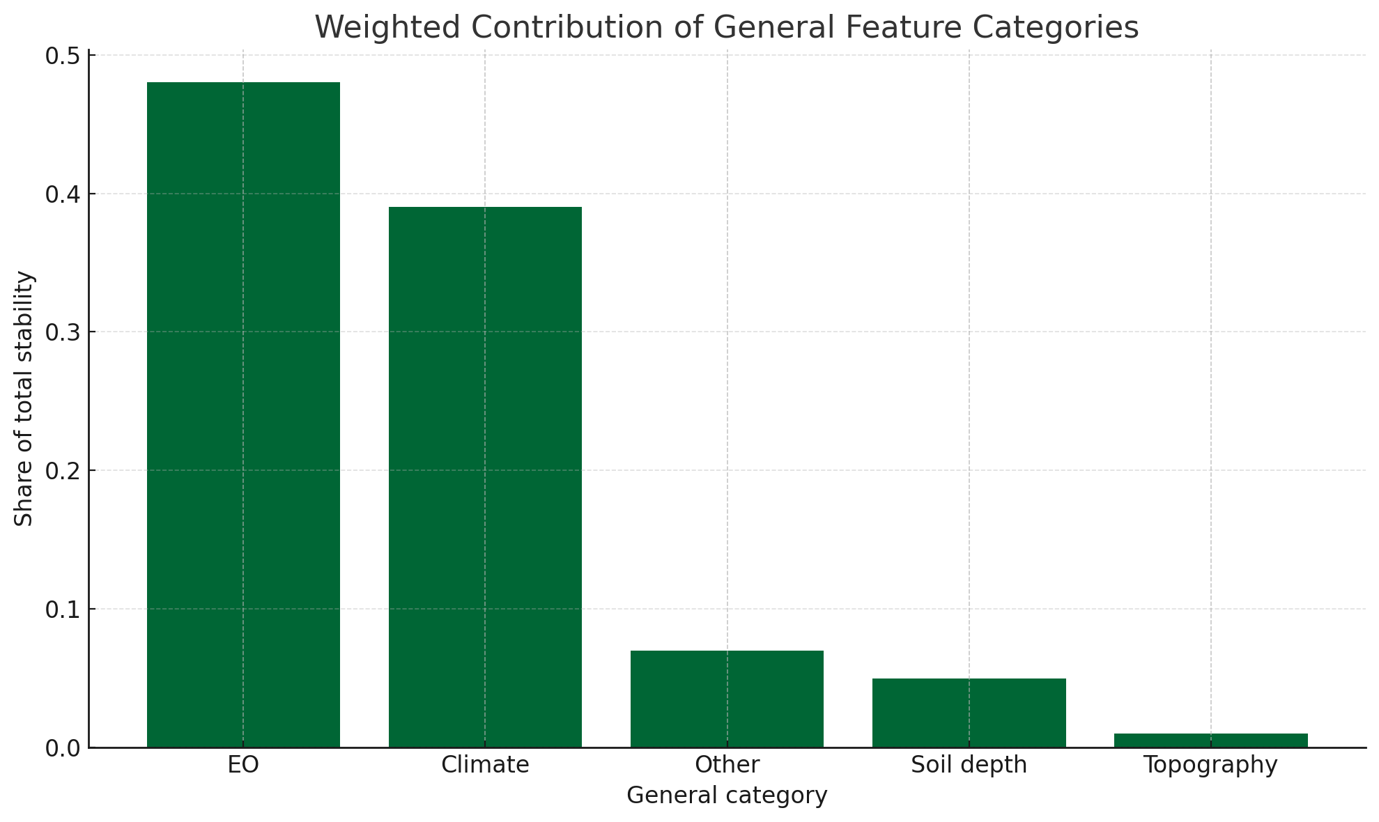
In this study, we present a scalable and robust system to estimate soil properties relevant for agronomic management, including SOC, total nitrogen (N), available phosphorus (P), exchangeable potassium (K), and soil pH (in H 2 O), on croplands. The system integrates Earth Observation (EO) data and environmental covariates using machine learning techniques to provide three-dimensional plus time (3D+T) estimates, capturing spatial variability, depth profiles, and temporal dynamics. This work contributes through its scale and design, notably the integration of physics-informed machine learning with state-of-the-art deep learning approaches, and the development of a robust and transparent validation framework. The objective is to evaluate the performance and limitations of such a system for agronomic decision-making, with a focus on enabling more precise and sustainable fertilizer management.
The proposed methodological framework builds on the SCORPAN paradigm of soil science [25], which conceptualizes soil properties as a function of state factors,
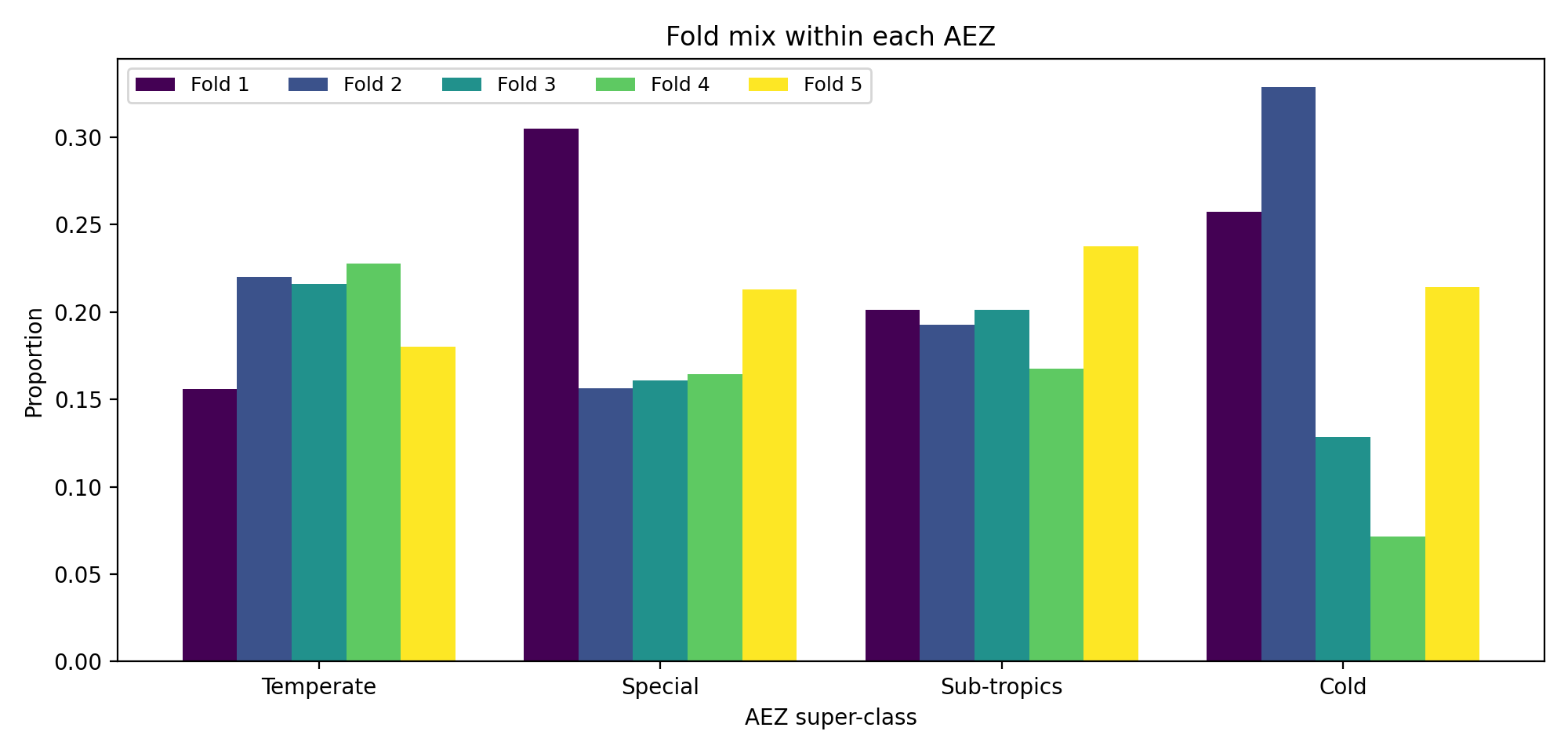
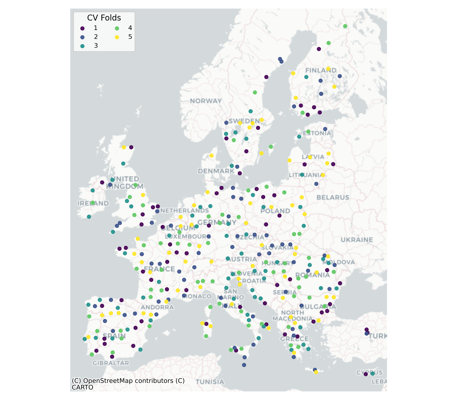
namely climate (c), organisms (o), relief (r), parent material (p), age (a), spatial position (n), and time (t). This formalism provides the basis for digital soil mapping: we instantiate f (•) with covariates, separating static factors (e.g., long-term climate normals, terrain, soils, geomorphology, land cover) from dynamic factors (e.g., monthly climate forcing, gap-free multispectral reflectance, phenology and productivity proxies, physics-informed canopy traits, and bare-soil reflectance). This separation makes the temporal factor explicit, modeling soil properties as a function of both static state factors and dynamic temporal covariates across multiple scales. The modeling objective is then to learn spatio-temporal mappings from these covariates to target soil properties while enforcing robustness and interpretability across het
This content is AI-processed based on open access ArXiv data.