Earth radius from a single sunrise image: a classroom-ready activity
Reading time: 5 minute
...
📝 Original Info
Title: Earth radius from a single sunrise image: a classroom-ready activity
ArXiv ID: 2512.06474
Date: 2025-12-06
Authors: ** - Florian Dubath¹ - Maria Alice Gasparini²,³ ¹ Department of Astronomy, University of Geneva, Switzerland ² Institute of Teacher Education, University of Geneva, Switzerland ³ Department of Physics, University of Geneva, Switzerland — **
📝 Abstract
Using a photograph of the shadow of Mont Blanc taken from Geneva at sunrise, we derive an upper limit for the Earth radius. After presenting the observational context and the model underlying assumptions, we determine the direction of the solar rays relative to the local vertical. This direction constrains the Earth maximum diameter which -- once corrected for atmospheric refraction -- amounts to roughly 1.7 times its presently accepted value. This work illustrates a pedagogical approach to scientific inquiry, showing how simple observations, combined with reasoning and elementary mathematical and geometrical tools, can yield meaningful physical estimates.
💡 Deep Analysis
📄 Full Content
Earth’s Radius from a Single Sunrise Image:
A Classroom-Ready Activity
Florian Dubath1 and Maria Alice Gasparini2,3
1Department of Astronomy, University of Geneva, Switzerland
2Institute of Teacher Education, University of Geneva, Switzerland
3Departement of Physics, University of Geneva, Switzerland
December 9, 2025
Abstract
Using a photograph of the shadow of Mont Blanc taken from Geneva at sun-
rise, we derive an upper limit for the Earth’s radius. After presenting the
observational context and the model’s underlying assumptions, we determine
the direction of the solar rays relative to the local vertical. This direction
constrains the Earth’s maximum diameter which – once corrected for atmo-
spheric refraction – amounts to roughly 1.7 times its presently accepted value.
This work illustrates a pedagogical approach to scientific inquiry, showing how
simple observations, combined with reasoning and elementary mathematical
and geometrical tools, can yield meaningful physical estimates.
1. Introduction
The estimation of Earth’s radius dates back to around 240 BC, when Eratosthenes
used the difference in Sun’s angle at noon at the summer solstice between Alexan-
dria and Syene (Aswan) to infer Earth’s circumference [1]. Much later, following
the French Revolution, Jean-Baptiste Delambre and Pierre Méchain measured part
of the meridian between Dunkirk and Barcelona; this measurement did indeed serve
as the basis for defining the meter [2,3].
Both of these historical methods relied on relatively simple means, whereas today
the calculation of Earth’s average radius combines gravimetric and astronomical
data, requiring more advanced technology [4,5]. All of these approaches, however,
involve measurements taken over large distances or at widely separated locations.
Under certain conditions, it is also possible to estimate Earth’s radius using only
local observations.
1
arXiv:2512.06474v1 [physics.ed-ph] 6 Dec 2025
In this paper, we estimate a conservative upper bound on Earth’s radius using a
photograph of Mont Blanc’s shadow taken from Geneva, together with the Sun’s
elevation at the time the picture was taken.
In Section 2, starting from the photograph, we present the observational context
and extract the data required for the subsequent analysis, including the camera’s
image-plane geometry. Section 3 derives the direction of the Sun’s rays relative
to the local vertical (celestial/solar geometry), which is then used in Section 4 to
constrain the Earth’s maximum diameter. In Section 5, this estimate is further cor-
rected by taking into account atmospheric refraction. Section 6 discusses the results
and presents the conclusions.
Beyond the quantitative result, this study illustrates a pedagogical approach to
scientific inquiry: starting from simple observations, we formulate hypotheses, con-
struct models, make approximations, and validate results. The method emphasizes
the role of careful measurement, reasoning, and the iterative refinement of models,
providing a concrete example of the scientific method in practice.
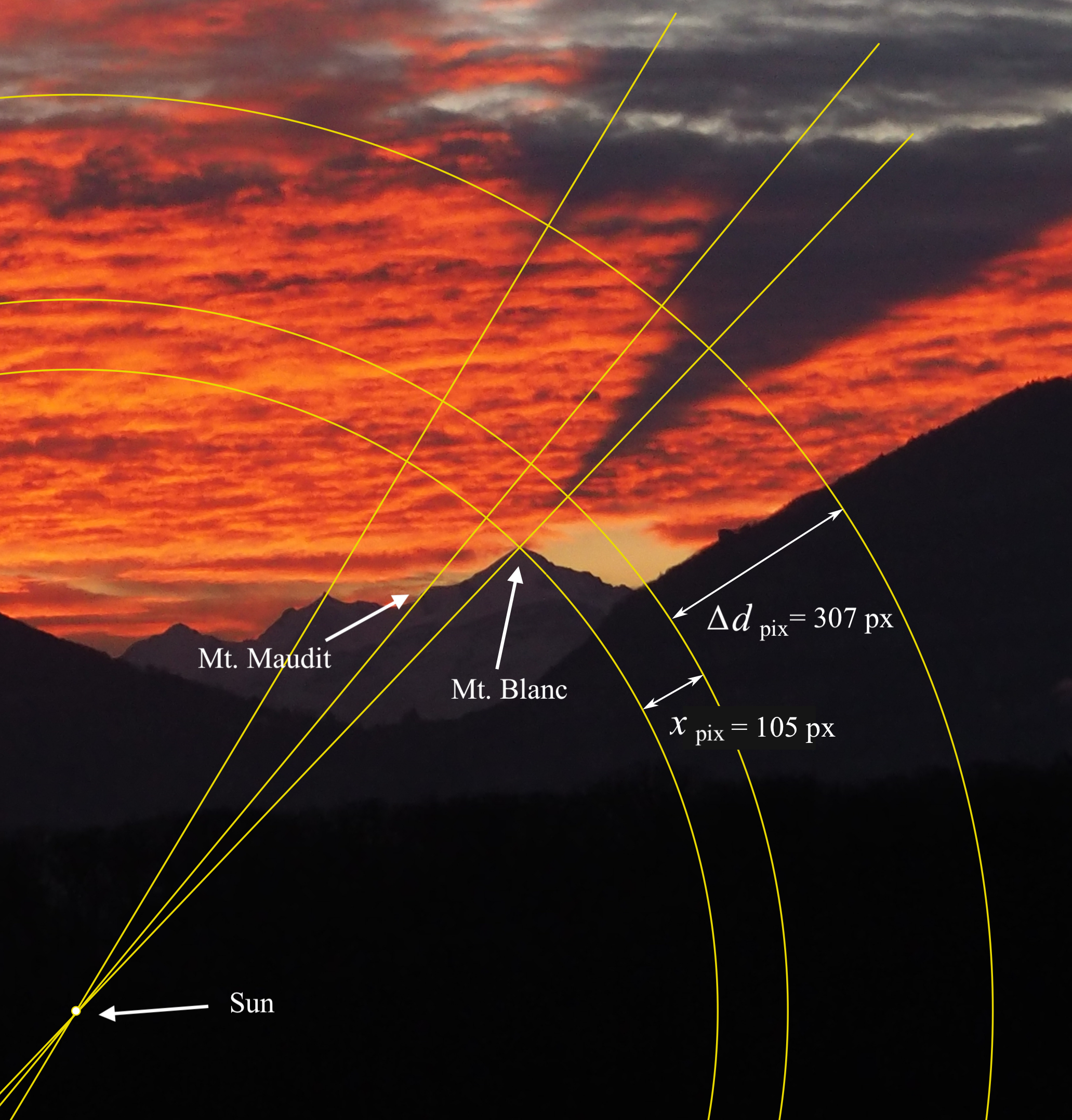
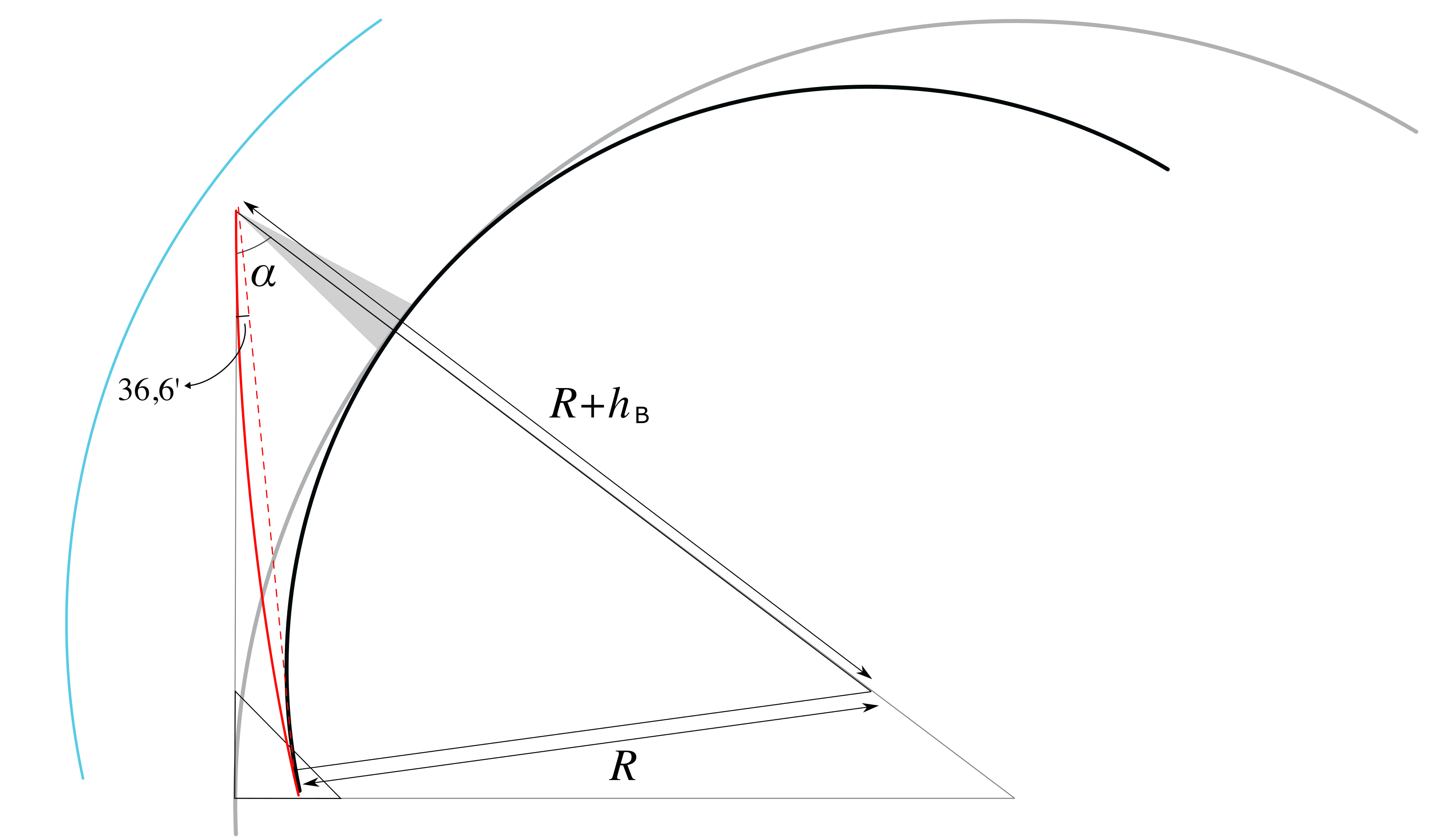
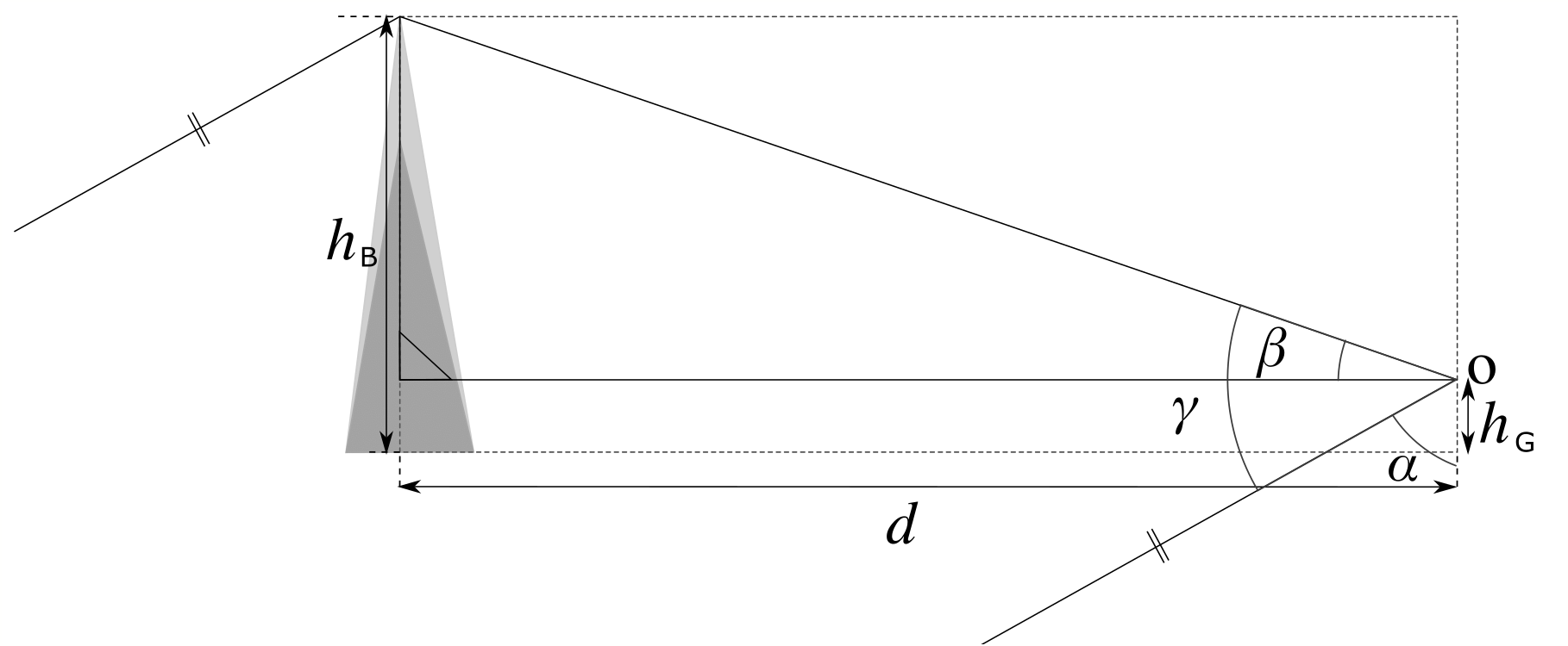
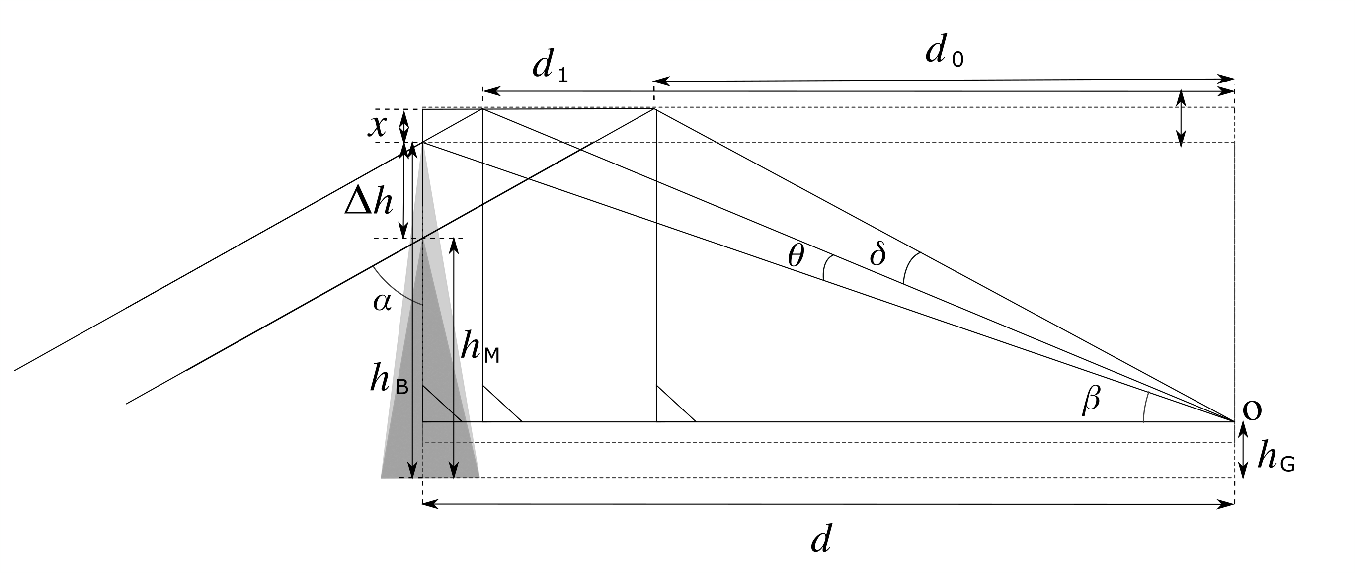
2. Image characteristics and observational data
The photograph in Fig. 1 was taken by one of the authors in Geneva on 7 January
2022 at 08 : 06 a.m. local time, when the Sun was still below the local horizon of the
photographer. The image shows the shadows of Mont Blanc and the adjacent peak
Mont Maudit projected onto the overlying stratus cloud layer; the Sun’s position
on the photograph corresponds to the intersection of the lines that connect each
mountain peak with its respective shadow (see also Fig. 3).
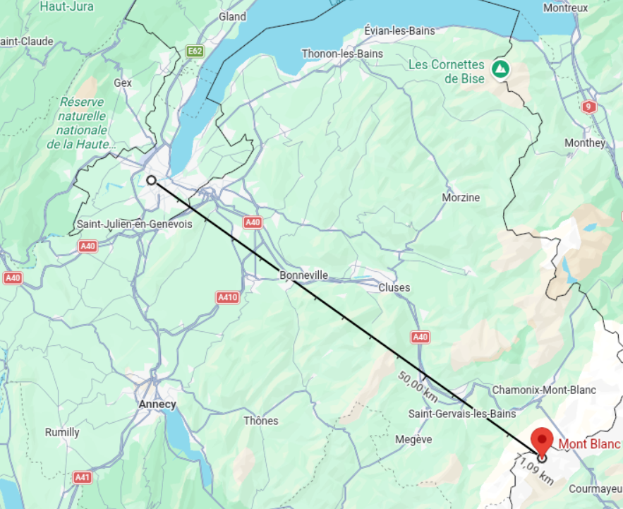
As seen on the map in Fig. 2, this direction is southeast relative to the observer,
while the shadows are cast toward the northwest, consistent with the time of sunrise.
Mont Blanc and Mont Maudit have elevations of hB = 4810 m and hM = 4465 m
above sea level, respectively. The observer is located in Geneva at an altitude of
hG = 430 m above sea level. The distance between the photographic location in the
Saint-Jean district and the summit of Mont Blanc is d = 71 km.
Moreover, measurements performed on the cropped photograph, as illustrated in
Fig. 3, indicate that the radial pixel separation between the two shadows is ∆dpix =
307 px, while the total image height of Fig. 1 is 4608 px. The radial separation
between Mont Blanc and its shadow is xpix = 105 px.
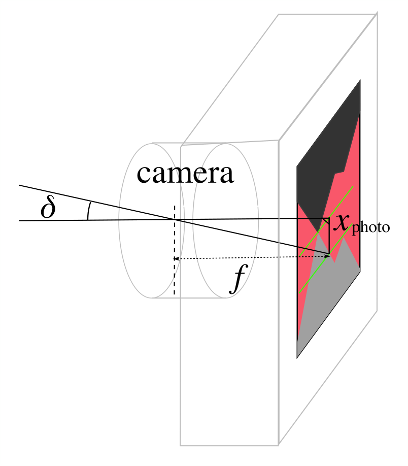
Although the pixel measurements extracted from the image provide relative dis-
tances, converting them into angular separations requires knowledge of the lens’s
focal length. The camera used for this photograph is equipped with a 4 : 3 sensor
(18.0 mm × 13.5 mm) and a lens of focal length f = 42.0 mm. These data allow
us first to convert the measured pixel lengths into physical distances on the sensor.
Then, using the elementary optics of a converging lens, we can deduce the corre-
2
Figure 1: The shadows of Mont Blanc and its neighbor, Mont Maudit, projected above
their summits onto a cloud layer illuminated by the rising Sun. The sunlig