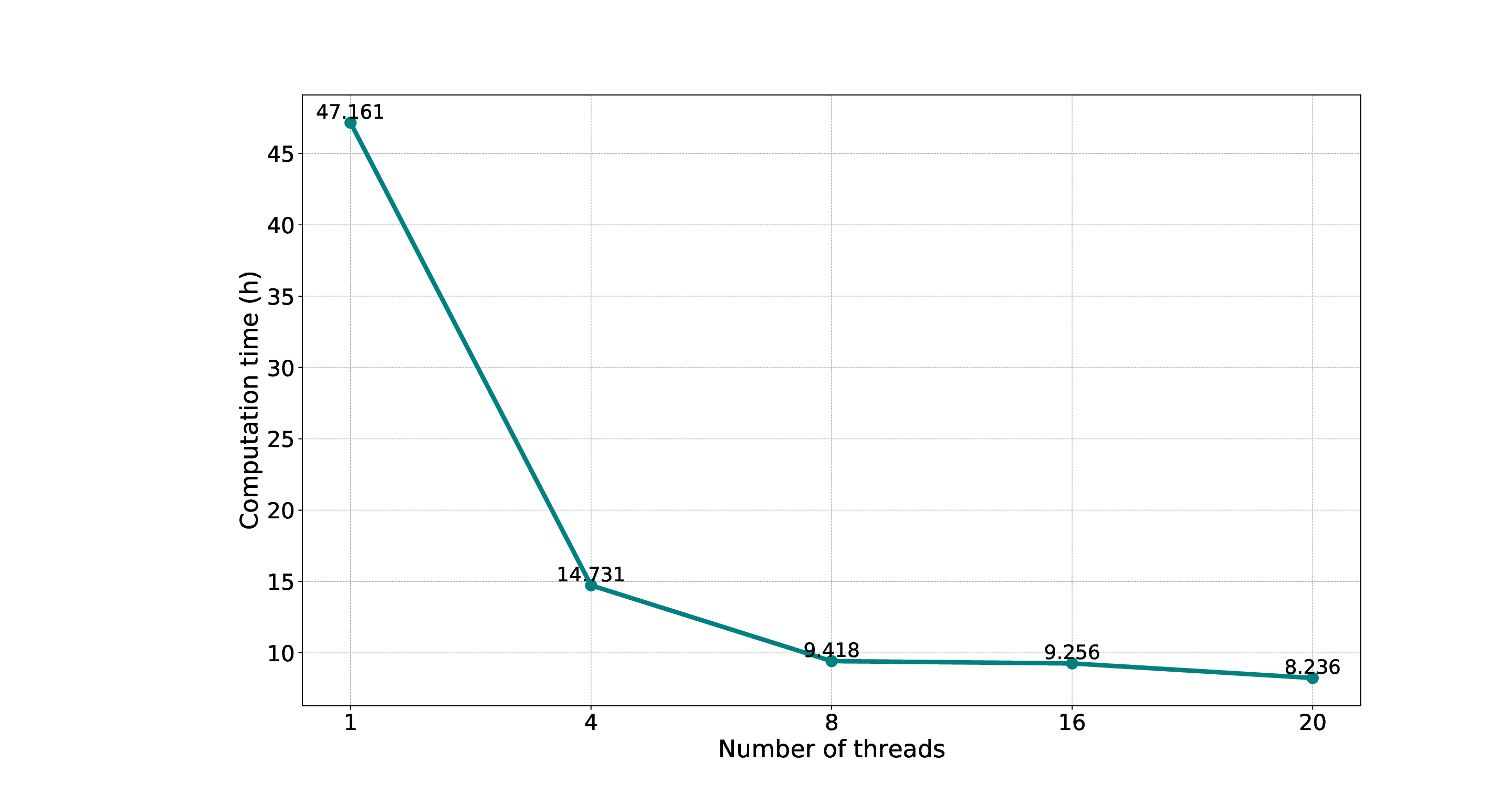
Risk communication seeks to develop a shared understanding of disaster among stakeholders, thereby amplifying public awareness and empowering them to respond more effectively to emergencies. However, existing studies have overemphasized specialized numerical modelling, making the professional output challenging to understand and use by non-research stakeholders. In this context, this article proposes a 3D virtual geographic environment for flood representation towards risk communication, which integrates flood modelling, parallel computation, and 3D representation in a pipeline. Finally, a section of the Rhine River in Bonn, Germany, is selected for experiment analysis. The experimental results show that the proposed approach is capable of flood modelling and 3D representation within a few hours, the parallel speedup ratio reached 6.45. The intuitive flood scene with 3D city models is beneficial for promoting flood risk communication and is particularly helpful for participants without direct experience of floods to understand its spatiotemporal process. It also can be embedded in the Geospatial Infrastructure Management Ecosystem (GeoIME) cloud application for intelligent flood systems.
As global climate change continues to exacerbate the extreme weather, floods have become the most frequent and destructive natural disaster leading to severe social and economic impacts [5,22,9,10,16,8]. In July 2021, summer storms and severe weather resulted in significant rainfall. The catastrophic floods severely affected some European countries (e.g., Germany, Belgium, Netherlands.), and caused more than 700 injuries and almost 200 deaths [23]. The economic losses amount to approximately 35.3 billion euros 1 . At almost the same time, intensive floods also occurred in China and the United States, this is a hint that the flood impacts are expected to increase, and become a global issue in the near future [6,3,5,29].
Besides, countries and emergency management have struggled to enhance flood mitigation and loss reduction worldwide [35]. In the last decade, the focus of flood mitigation has shifted from flood protection to risk management [5,21,53]. As an integral part of flood risk management, risk communication is an interactive process of information exchange, which aims to share flood information among stakeholders, convince the population at risk to be prepared for an emergency, and improve risk awareness [12,7,30,53,52].
In the early stages, flood risk information is generally communicated to the people by radio, TV, and community staff door-knocking in some circumstances. Subsequently, geoinformatics and hydrological modelling are introduced into flood risk management. The most representative product is the flood risk/hazard map, which overlays 2D flood modelling output with resource maps to improve government preparedness and individual response to floods [34,40,13,43,5,22]. The flood map is straightforward, but it is not intuitive due to poor topographic auxiliary information compared with the 3D representation [48,50].
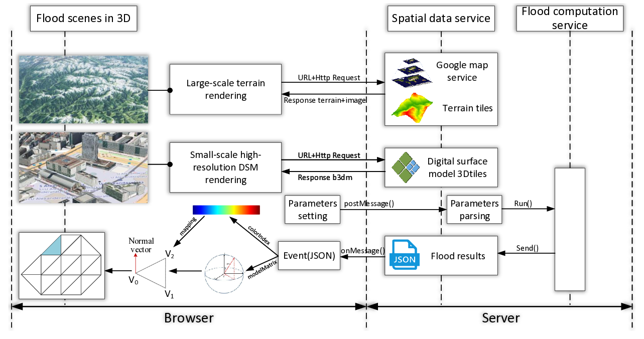
More precisely, 3D representation enables the effortless understanding of complicated flood phenomena and presents its process without temporal and spatial impediments [48,14], which has been proven to enhance communication among various stakeholders and improve the effectiveness of decision-making processes [47,2,37,50,5,24]. For example, flood representation in 3D enhances awareness and minimizes losses associated with flooding. It offers a realistic visualization of flood scenarios, clearly understanding potential risks. This immersive experience aids in better preparation and community engagement [24]. Decision-makers can use it to evaluate flood management strategies, while emergency responders can train using simulated scenarios. Additionally, it serves as a powerful advocacy tool for securing funding for flood mitigation projects.
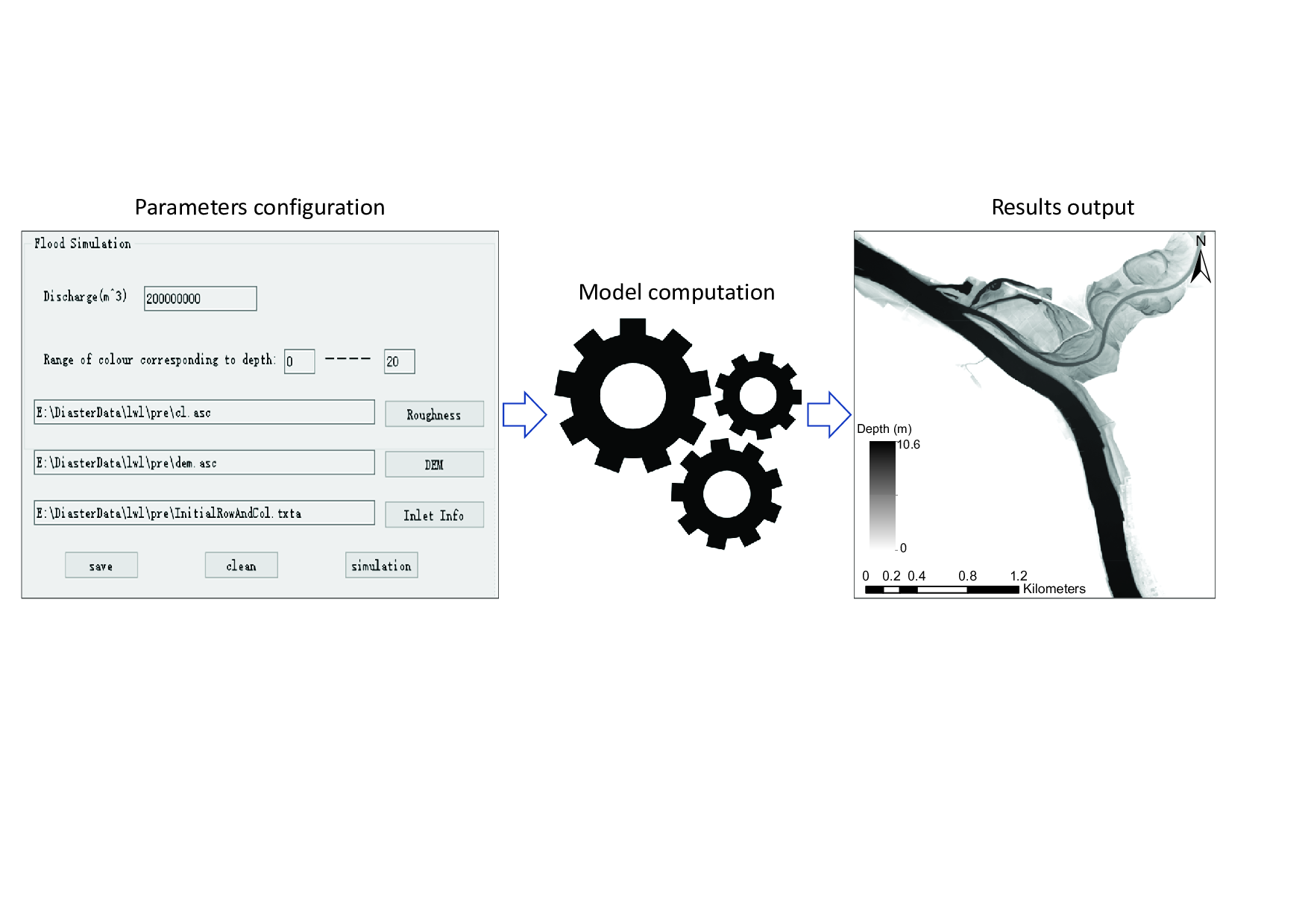
However, 3D flood representation has remained with some challenges [46]: (1) Fast model computation in which the flood modelling results should be provided within hours to serve various mitigation actions; (2) Effective information representation, in which visualization is the window to communicate flood risk to stakeholders in the community. To our best knowledge, the hydraulics software (e.g., MIKE2 , Delft 3D3 ) has undergone significant development to meet the target of decision-makers for accurate prediction of floods. However, they are more used by research-level organizations and hardly maximize their potential in communicating flood risks to stakeholders in the community.
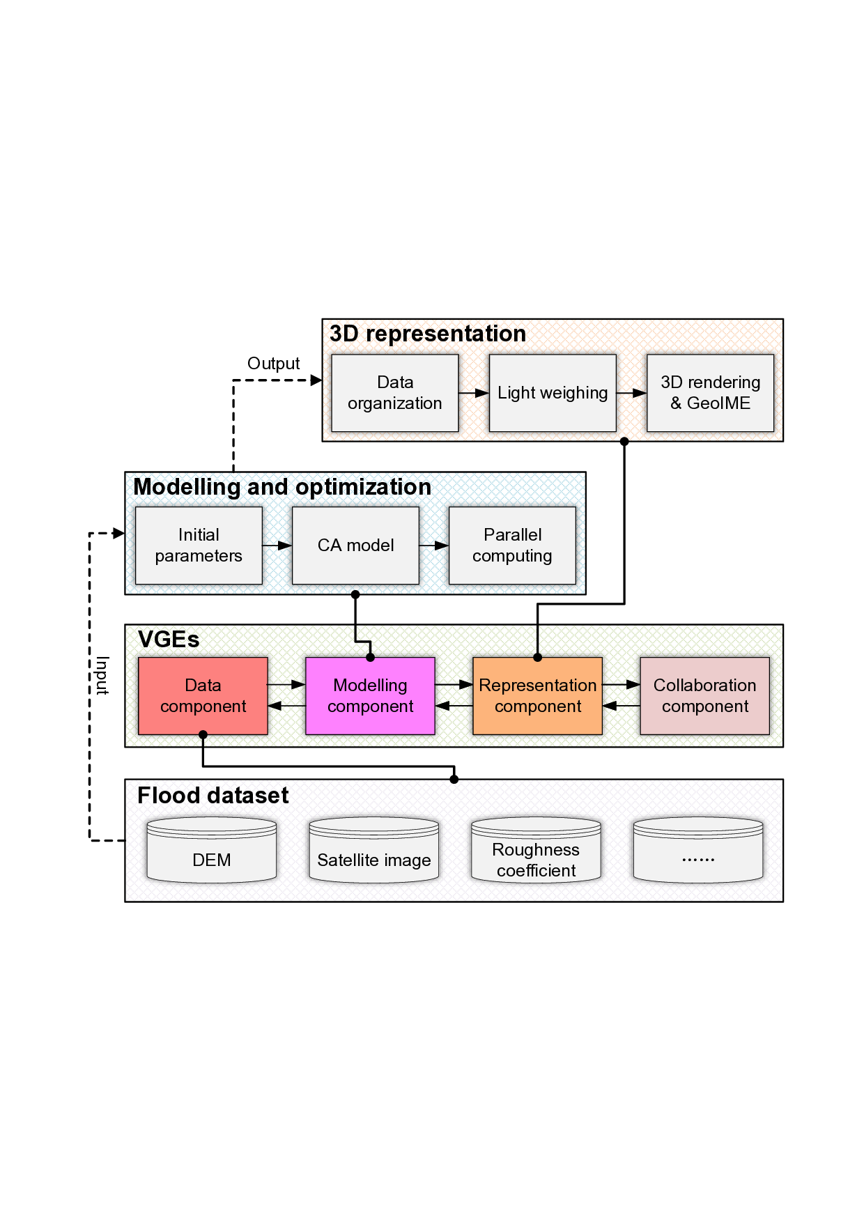
In this context, this article proposes a 3D virtual geographic environment that integrates flood spatiotemporal modelling, parallel computation, and 3D representation like a workflow. Therefore, we aim to improve the computational efficiency of flood modelling and thus serve disaster management promptly. The 3D representation also allows flood modelling to move from specialized outputs to intuitive 3D scenes, providing a valuable platform for substantial risk communication among stakeholders, particularly for people without direct experience with floods who can perceive flood propagation from an all-round perspective.
The remainder of this article is organized as follows: In Section 2 the related work of this study is reviewed. Section 3.1 provides a study framework for this article. Sections 3.2, 3.3, and 3.4 introduce flood spatiotemporal modelling, parallel computation, and web 3D visualization, respectively. In Section 4 the case experiment is conducted and analyzed, and findings are summarized.
Finally, Sections 5 and 6 present the discussion and conclusion.
The development of humankind is a history of struggle against disasters, and the exploration of disasters has gone through a long historical period and formed a series of mitigation strategies [22]. In 1936, the United States issued the Flood Control Act to enhance structural defences, and such mitigation measures gradually became the principal strategy in many countries [38]. Obviously, structural measures are the most direct but also the most expensive ways to mitigate flood hazards. Later on, some studi
This content is AI-processed based on open access ArXiv data.