Title: Extracting Disaster Impacts and Impact Related Locations in Social Media Posts Using Large Language Models
ArXiv ID: 2511.21753
Date: 2025-11-24
Authors: Sameeah Noreen Hameed, Surangika Ranathunga, Raj Prasanna, Kristin Stock, Christopher B. Jones
📝 Abstract
Large-scale disasters can often result in catastrophic consequences on people and infrastructure. Situation awareness about such disaster impacts generated by authoritative data from in-situ sensors, remote sensing imagery, and/or geographic data is often limited due to atmospheric opacity, satellite revisits, and time limitations. This often results in geo-temporal information gaps. In contrast, impact-related social media posts can act as "geo-sensors" during a disaster, where people describe specific impacts and locations. However, not all locations mentioned in disaster-related social media posts relate to an impact. Only the impacted locations are critical for directing resources effectively. e.g., "The death toll from a fire which ripped through the Greek coastal town of #Mati stood at 80, with dozens of people unaccounted for as forensic experts tried to identify victims who were burned alive #Greecefires #AthensFires #Athens #Greece." contains impacted location "Mati" and non-impacted locations "Greece" and "Athens". This research uses Large Language Models (LLMs) to identify all locations, impacts and impacted locations mentioned in disaster-related social media posts. In the process, LLMs are fine-tuned to identify only impacts and impacted locations (as distinct from other, non-impacted locations), including locations mentioned in informal expressions, abbreviations, and short forms. Our fine-tuned model demonstrates efficacy, achieving an F1-score of 0.69 for impact and 0.74 for impacted location extraction, substantially outperforming the pre-trained baseline. These robust results confirm the potential of fine-tuned language models to offer a scalable solution for timely decision-making in resource allocation, situational awareness, and post-disaster recovery planning for responders.
💡 Deep Analysis
📄 Full Content
Extracting Disaster Impacts and Impact Related Locations in
Social Media Posts Using Large Language Models
Sameeah Noreen Hameeda, Surangika Ranathungaa, Raj Prasannaa, Kristin Stocka,
and Christopher B. Jonesb
aSchool of Mathematical and Computational Sciences, Massey University, Auckland, New
Zealand; bSchool of Computer Science and Informatics, Cardiff University, Cardiff, UK
ARTICLE HISTORY
Compiled December 1, 2025
ABSTRACT
Large-scale disasters can often result in catastrophic consequences on people and
infrastructure. Situation awareness about such disaster impacts generated by au-
thoritative data from in-situ sensors, remote sensing imagery, and/or geographic
data is often limited due to atmospheric opacity, satellite revisits, and time limi-
tations. This often results in geo-temporal information gaps. In contrast, impact-
related social media posts can act as “geo-sensors” during a disaster, where people
describe specific impacts and locations. However, not all locations mentioned in
disaster-related social media posts relate to an impact. Only the impacted locations
are critical for directing resources effectively. e.g., “The death toll from a fire which
ripped through the Greek coastal town of #Mati stood at 80, with dozens of people
unaccounted for as forensic experts tried to identify victims who were burned alive
#Greecefires #AthensFires #Athens #Greece.” contains impacted location “Mati”
and non-impacted locations “Greece” and “Athens”. This research uses Large Lan-
guage Models (LLMs) to identify all locations, impacts and impacted locations men-
tioned in disaster-related social media posts. In the process, LLMs are fine-tuned to
identify only impacts and impacted locations (as distinct from other, non-impacted
locations), including locations mentioned in informal expressions, abbreviations, and
short forms. Our fine-tuned model demonstrates efficacy, achieving an F1-score of
0.69 for impact and 0.74 for impacted location extraction, substantially outperform-
ing the pre-trained baseline. These robust results confirm the potential of fine-tuned
language models to offer a scalable solution for timely decision-making in resource
allocation, situational awareness, and post-disaster recovery planning for responders.
KEYWORDS
Social media posts; Disaster response; Large Language Models(LLMs); Locations;
Geospatial; Toponym recognition
1.
Introduction
Disasters, triggered by natural hazards, are a major challenge that can have a devastat-
ing impact on the lives of people and infrastructure. Effective disaster management and
response rely heavily on the availability of accurate information, delivered in a timely
manner and appropriate format [1]. Authoritative data, derived from sources such as
in-situ sensors, remote sensing imagery, and geographic information systems (GIS) are
vital for performing accurate damage assessments and coordinating relief operations [2].
CONTACT Sameeah Noreen Hameed Email: snoreen1@massey.ac.nz
arXiv:2511.21753v1 [cs.CL] 24 Nov 2025
However, the acquisition of this sensor-based information is often constrained by real-
world limitations, such as atmospheric opacity, which can obscure satellite views, or the
inherent revisit time limitations of satellites [3, 4]. These constraints frequently lead to
critical geo-temporal gaps, where timely data is unavailable [5, 6]. To address this infor-
mation deficit and improve situational awareness, studies utilise alternative data sources
such as social media text [7]. Social media with its vast user base and real-time com-
munication capabilities, has emerged as a powerful tool for gathering and disseminating
critical information during disasters [8]. Platforms such as Twitter, Facebook, and In-
stagram allow users to share first-hand observations and updates about ongoing events,
effectively transforming social media into a network of Volunteered Geographic Infor-
mation (VGI) [9]. These platforms serve as a “geo-sensor” network, providing valuable
real-time data that can complement traditional remote sensing methods and enhance
situational awareness for emergency services. Social media platforms are more respon-
sive with a more continuous flow of information during disaster times than official data,
which comes in intervals that are often too long [10].
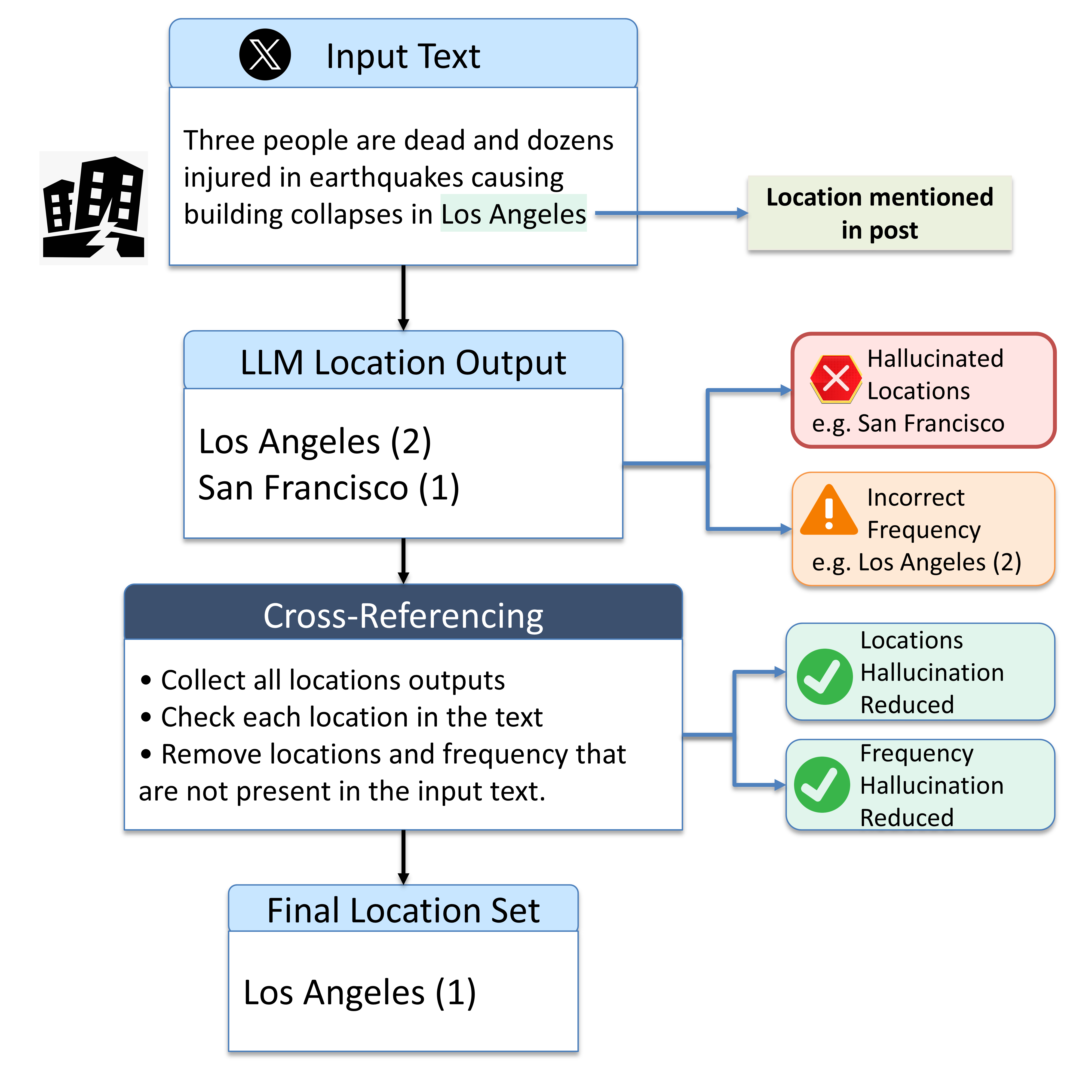
Figure 1.: LLM-based real-time disaster impact mapping from social media data. The
process filters non-impact locations to help emergency managers target and prioritise
response efforts.
However, the sheer volume of information generated on social media during disasters
presents its own set of challenges. One of the key challenges is the identification and
extraction of relevant geographic locations, or toponyms (geographically locatable place
names), from the vast stream of posts [11]. These locations are critical for mapping
2
the spatial extent of a disaster and understanding its impact. Situational awareness
in disaster scenarios hinges on the ability to accurately