Authors: Sukanya Randhawa¹*, Guntaj Randhawa², Clemens Langer¹², Francis Andorful¹², Benjamin Herfort¹, Daniel Kwakye², Omer Olchik¹, Sven Lautenbach¹²³, Alexander Zipf¹²³ ¹Heidelberg Institute of Geoinformation Technology (HeiGIT), Heidelberg, Germany ²GIScience Chair, Institute of Geography, Heidelberg University, Germany ³Centre for the Environment, Heidelberg University, Germany *Corresponding author: sukanya.randhawa@heigit.org
📝 Abstract
Resilient road infrastructure is a cornerstone of the UN Sustainable Development Goals. Yet a primary indicator of network functionality and resilience is critically lacking: a comprehensive global baseline of road surface information. Here, we overcome this gap by applying a deep learning framework to a global mosaic of Planetscope satellite imagery from 2020 and 2024. The result is the first global multi-temporal dataset of road pavedness and width for 9.2 million km of critical arterial roads, achieving 95.5% coverage where nearly half the network was previously unclassified. This dataset reveals a powerful multi-scale geography of human development. At the planetary scale, we show that the rate of change in pavedness is a robust proxy for a country's development trajectory (correlation with HDI = 0.65). At the national scale, we quantify how unpaved roads constitute a fragile backbone for economic connectivity. We further synthesize our data into a global Humanitarian Passability Matrix with direct implications for humanitarian logistics. At the local scale, case studies demonstrate the framework's versatility: in Ghana, road quality disparities expose the spatial outcomes of governance; in Pakistan, the data identifies infrastructure vulnerabilities to inform climate resilience planning. Together, this work delivers both a foundational dataset and a multi-scale analytical framework for monitoring global infrastructure, from the dynamics of national development to the realities of local governance, climate adaptation, and equity. Unlike traditional proxies such as nighttime lights, which reflect economic activity, road surface data directly measures the physical infrastructure that underpins prosperity and resilience - at higher spatial resolution.
💡 Deep Analysis
📄 Full Content
The changing surface of the world’s roads
Sukanya Randhawa1,*, Guntaj Randhawa2, Clemens Langer1,2, Francis Andorful1,2,
Benjamin Herfort1, Daniel Kwakye2, Omer Olchik1, Sven Lautenbach1,2,3, and Alexander
Zipf1,2,3
1Heidelberg Institute of Geoinformation Technology (HeiGIT), Berliner Str. 45 (Mathematikon), 69120 Heidelberg,
Germany
2GIScience Chair, Institute of Geography, Heidelberg University, Im Neuenheimer Feld 368, 69120 Heidelberg,
Germany
3Centre for the Environment, Heidelberg University, Im Neuenheimer Feld 130.1, 69120 Heidelberg, Germany
*sukanya.randhawa@heigit.org
ABSTRACT
Resilient road infrastructure is a cornerstone of the UN Sustainable Development Goals. Yet a primary indicator of network
functionality and resilience is critically lacking: a comprehensive global baseline of road surface information. Here, we overcome
this gap by applying a deep learning framework to a global mosaic of Planetscope satellite imagery from 2020 and 2024. The
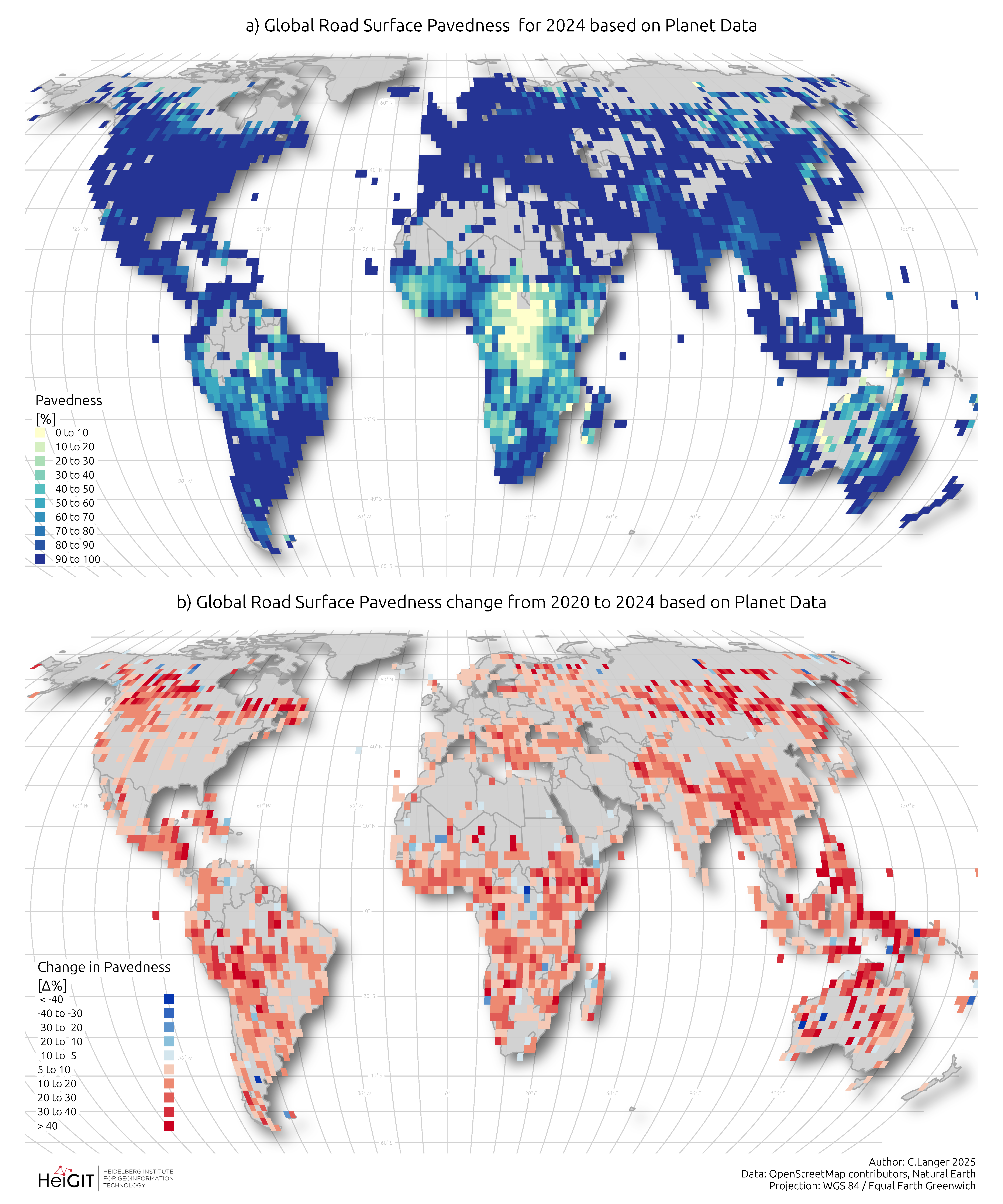
result is the first global multi-temporal dataset of road pavedness and width for 9.2 million km of critical arterial roads, achieving
95.5% coverage where nearly half the network was previously unclassified.
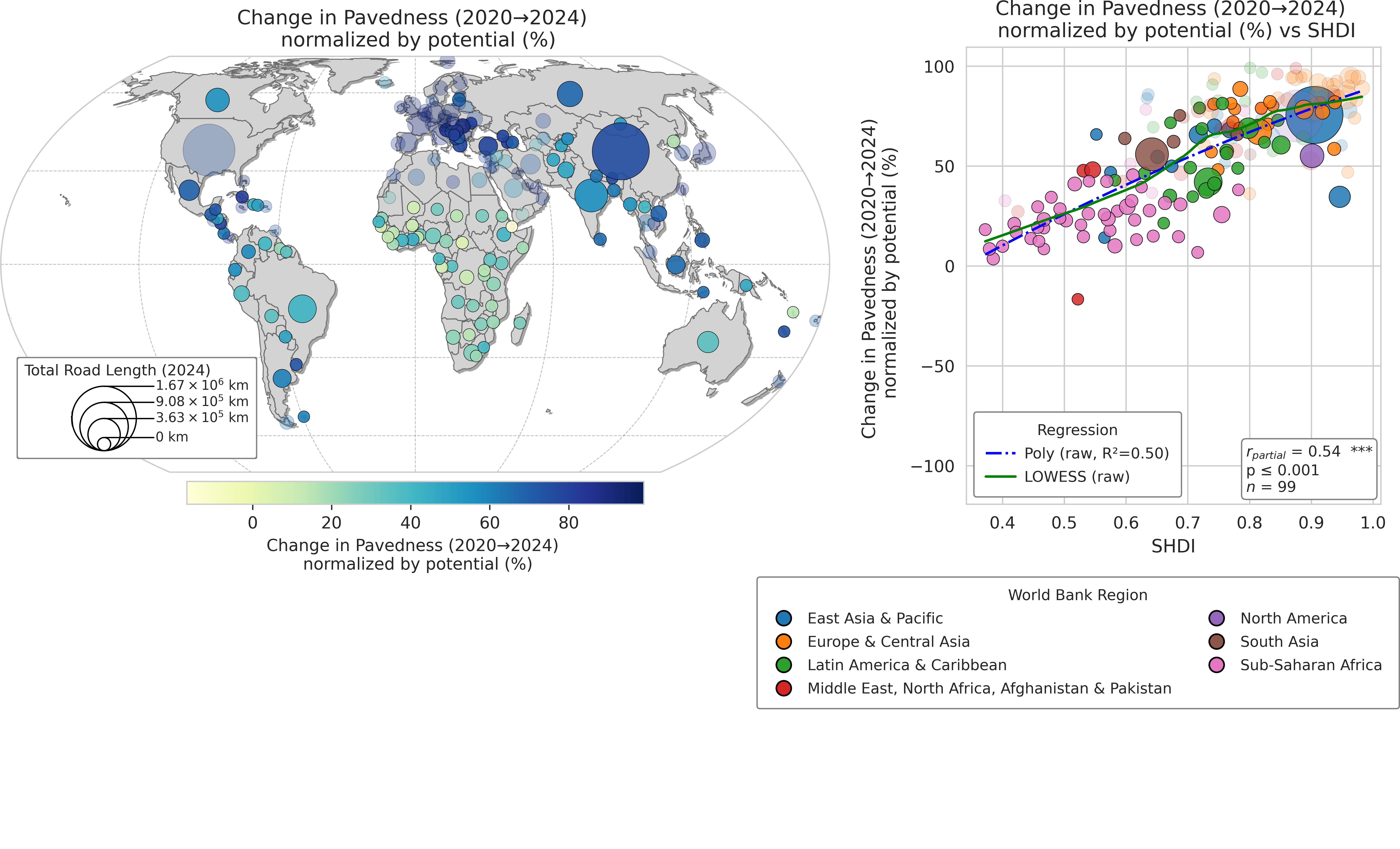
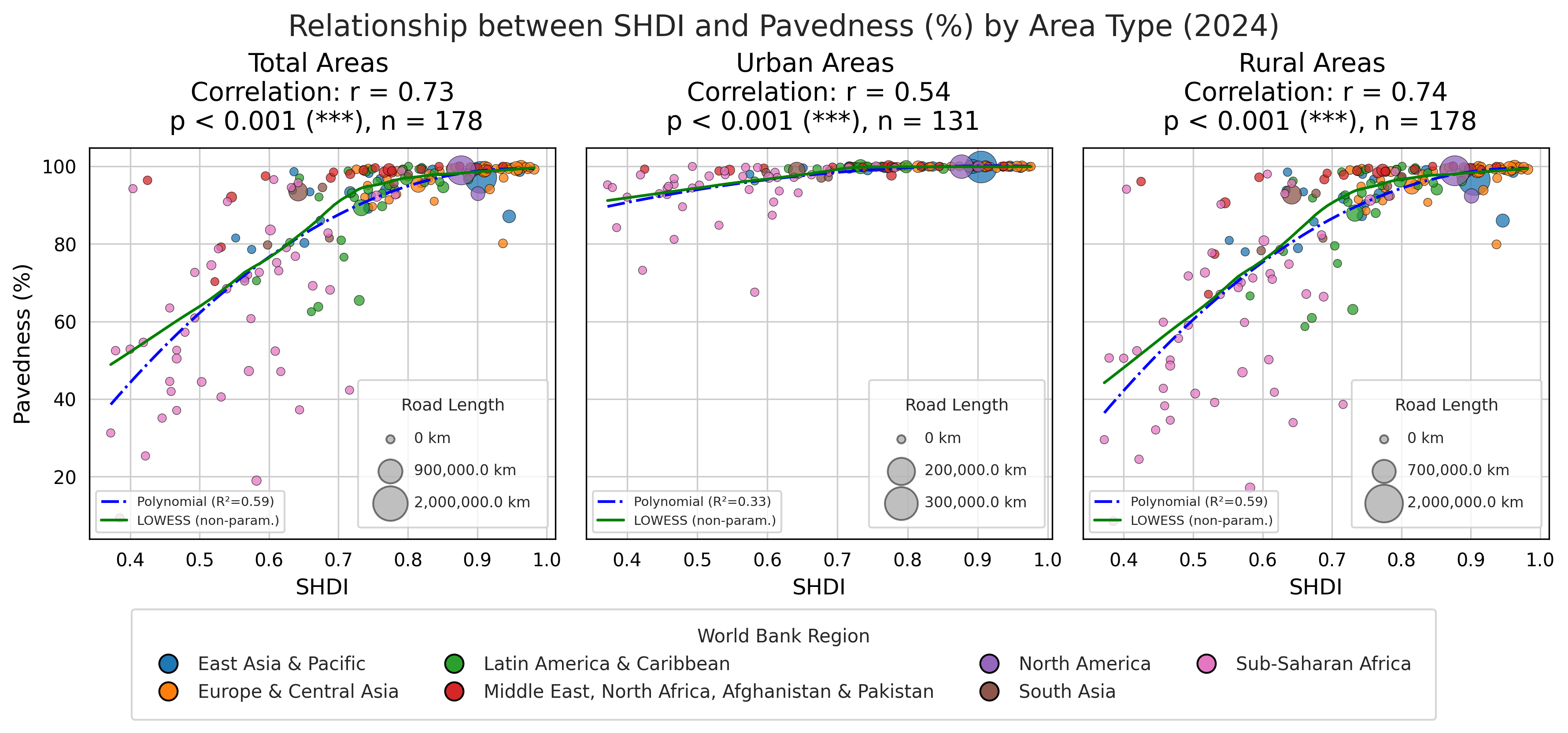
This dataset reveals a powerful multi-scale geography of human development. At the planetary scale, we show that the rate of
change in pavedness is a robust proxy for a country’s development trajectory (correlation with HDI = 0.65). At the national
scale, we quantify how unpaved roads constitute a fragile backbone for economic connectivity. We further synthesize our data
into a global Humanitarian Passability Matrix with direct implications for humanitarian logistics. At the local scale, case studies
demonstrate the framework’s versatility: in Ghana, road quality disparities expose the spatial outcomes of governance; in
Pakistan, the data identifies infrastructure vulnerabilities to inform climate resilience planning. Together, this work delivers both
a foundational dataset and a multi-scale analytical framework for monitoring global infrastructure, from the dynamics of national
development to the realities of local governance, climate adaptation, and equity. Unlike traditional proxies such as nighttime
lights, which reflect economic activity, road surface data directly measures the physical infrastructure that underpins prosperity
and resilience—at higher spatial resolution.
Introduction
Road networks are the arteries of the global economy, essential for trade, social integration, and access to fundamental
services such as healthcare and education1,2. The quality of this infrastructure, determined largely by its surface type, plays a
pivotal role in determining transportation efficiency, disaster resilience, and progress towards the United Nations Sustainable
Development Goals3–5. The distinction between paved and unpaved roads shapes not only per capita income levels6 but also a
nation’s vulnerability to climate-related disruptions such as floods and extreme weather events7–9. Consequently, accurate,
high-resolution and up-to-date global data on road surface conditions is not merely a logistical asset but a fundamental
prerequisite for monitoring economic progress, targeting infrastructure investment, and assessing climate vulnerability.
While previous research has relied heavily on proxies such as nighttime light intensity to infer economic activity and
human development10,11, such radiance-based measures remain limited by their coarse spatial resolution and their indirect
relationship to the underlying physical infrastructure that enables growth. In contrast, road surface characteristics offer a direct,
high-resolution, and functionally grounded signal of economic investment, accessibility, and resilience—capturing dimensions
of human development that nighttime lights cannot resolve.
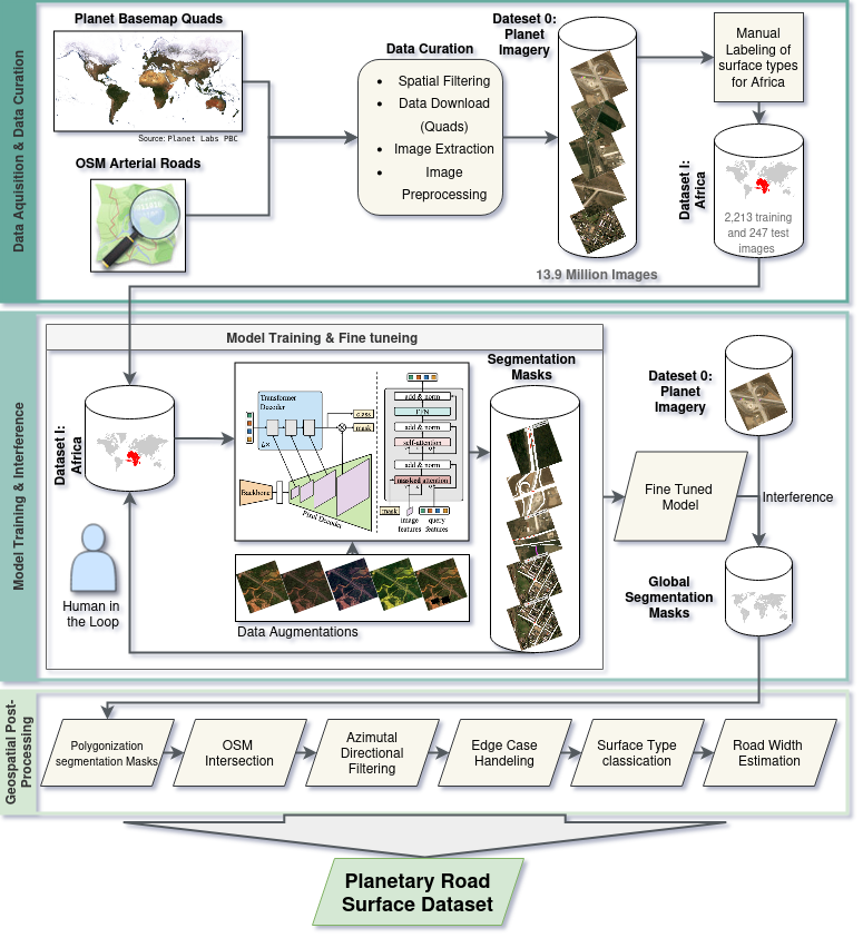
Yet despite this critical need — and substantial progress made by large-scale geospatial AI - a comprehensive global
baseline of road surface information remains elusive at the time of writing. Recent years have seen remarkable progress in
deriving geospatial datasets of the built environment, driven by large-scale AI initiatives. Recent datasets from organizations
like Meta AI12 and Microsoft13 have improved the completeness of global road network geometries, while parallel efforts from
Microsoft14 and Google15 have provided comprehensive inventories of building footprints. However, while these datasets have
enhanced our understanding of the presence and location of global infrastructure, they do not capture the critical attributes that
determine functionality and resilience. This semantic data gap—the absence of physical detail such as surface type—represents
a major limitation in current infrastructure intelligence. The current de facto standard, OpenStreetMap (OSM), is a monumental
arXiv:2512.04092v1 [physics.soc-ph] 17 Nov 2025
achievement, yet its surface attributes are quite incomplete—covering only 30-40% of the global network—and are often
outdated16–18.