The rapid urbanization and increasing traffic have serious social, economic, and environmental impact on metropolitan areas worldwide. It is of a great importance to understand the complex interplay of road networks and traffic conditions. The authors propose a novel framework to estimate traffic conditions at the metropolitan scale using GPS traces. Their approach begins with an initial estimation of network travel times by solving a convex optimization program based on traffic flow theory. Then, they iteratively refine the estimated network travel times and vehicle traversed paths. Last, the authors perform a bilevel optimization process to estimate traffic conditions on road segments that are not covered by GPS data. The evaluation and comparison of the authors' approach over two state-of-the-art methods show up to 96.57% relative improvements. The authors have further conducted field tests by coupling road networks of San Francisco and Beijing with real-world GIS data, which involve 128,701 nodes, 148,899 road segments, and over 26 million GPS traces.
Traffic has become a major problem in metropolitan areas around the world. The extra cost due to traffic congestion and accidents are assessed over one trillion dollars worldwide. Therefore, understanding the complex interplay of road networks and travel conditions has been of a great interest in many contexts including improving simulation techniques (1), analyzing urban infrastructure (2), understanding human mobility (3), and designing better routing strategies (4). These applications highlight a need for developing a systematical framework that is capable of estimating traffic conditions using real-time sensor data.
We adopt GPS data for estimating citywide traffic conditions and use three processes to address the data features such as low-sampling rate and spatial-temporal sparsity: map-matching (5,6,7,8), travel-time inference (9,10,11,12,13), and missing-value completion (6,14). While significant improvements have been achieved in these sub-areas, they are usually executed in tandem, which result in cascading errors and deteriorated estimations. Our framework conducts the estimation by first obtaining a coarse inference through a convex optimization program. Then, it refines the inferred vehicle paths and traffic conditions via iteratively performing map-matching and travel-time inference. Next, to handle the spatial sparsity, it conducts a nested optimization: the upper level aims to derive the optimal trip distributions among different areas in a road network while the lower level satisfies the constraints imposed by Wardrop Principles (15,16). Finally, the framework addresses temporal sparsity using the Compressed-Sensing algorithm (6).
We evaluate our framework using a real road network that consists of 5407 nodes and 1612 road segments, 34 heuristic network travel times corresponding to various congestion levels and times of a day, and over 10 million sampled GPS traces. The effectiveness of our approach has been compared to the state-of-the-art methods, namely Hunter et al. (17) and Rahmani et al. (12), resulting in up to 96% relative improvements. To showcase our implementation, we conduct the field tests in Beijing and San Francisco using real-world GIS datasets, which contain 128701 nodes, 148899 road segments, and over 26 million GPS traces. The full report of this work can be found at gamma.cs.unc.edu/CityEst/ (18).
Our goal is to estimate traffic conditions of a city-scale network. We explicitly address two challenges presented by GPS data: the low-sampling rate and the spatial-temporal sparsity through three steps: coarse inference, iterative refinement, and nested estimation. Traffic is commonly assumed to be quasi-static and has a weekly period (17,19). Based on these observations, we divide an entire week into discrete time intervals and treat the traffic within each interval as static. In this section, we focus our discussion on the three steps over a single time interval. The temporal missing values over an entire traffic period are interpolated using the technique developed in (6).
There are three key features of our work. First, for addressing the low-sampling-rate data, we use an iterative refinement rather than a sequential computation so that errors of the map-matching and travel-time inference processes are gradually reduced. Second, for addressing the spatial sparsity, we incorporate the sensing results generated from a large number of probe vehicles into the traffic assignment program so that we can compute travel times and flows of all road segments in a network. Third, our approach relies heavily on knowledge of transportation engineering, in which field the robust studies allow our modeling of traffic one step closer to the real-world traffic.
In order to evaluate our approach, we use the road network from downtown San Francisco (obtained from openstreetmap.org) as the benchmark. The network contains 5407 nodes, 1612 road segments, and 296 TAZs (obtained from data.sfgov.org). We have also generated a set of heuristic network travel times using the System Optimal (SO) model and the Timestamp model based on the Cabspotting dataset (obtained from crawdad.org) as the ground truth.
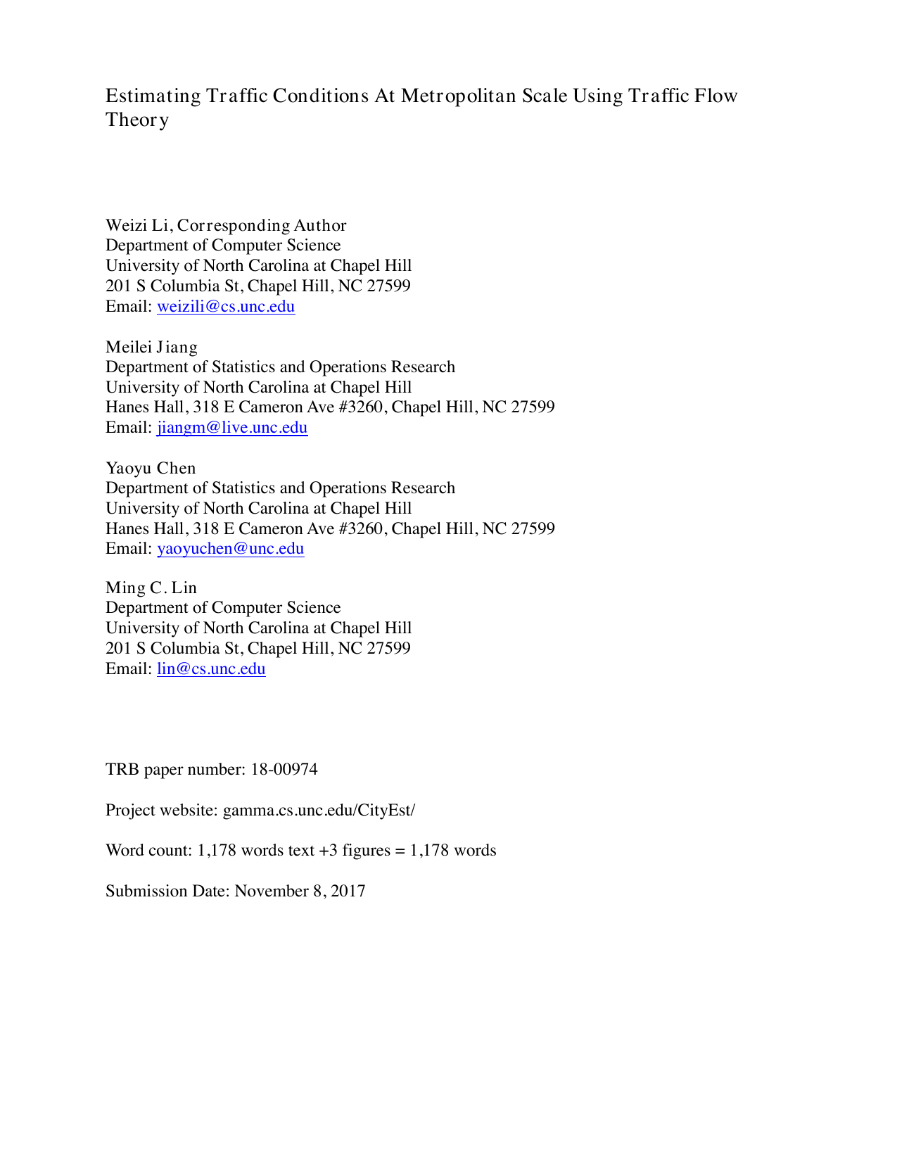
We compare our work to Hunter et al. (17) and Rahmani et al. ( 12) using three measurements. The first metric is the performance gain of our technique over existing methods on travel times by considering all road segments of a network. The second metric is the error rate of the aggregate travel time of the entire network. The third metric regards the map-matching accuracy. The results are shown in Figure 1. Our method achieves as low as 8% error rate and as high as 96% relative improvement compared to the other two techniques.
We conduct field tests on two diverse cities in two continents, namely Beijing and San Francisco. The GPS datasets used in the field tests are from the Cabspotting project and T-drive project (20), respectively.
The results shown in Figure 2 demonstrate the estimated t
This content is AI-processed based on open access ArXiv data.