OpenPathNet: An Open-Source RF Multipath Data Generator for AI-Driven Wireless Systems
The convergence of artificial intelligence (AI) and sixth-generation (6G) wireless technologies is driving an urgent need for large-scale, high-fidelity, and reproducible radio frequency (RF) datasets. Existing resources, such as CKMImageNet, primari…
Authors: Lizhou Liu, Xiaohui Chen, Wenyi Zhang
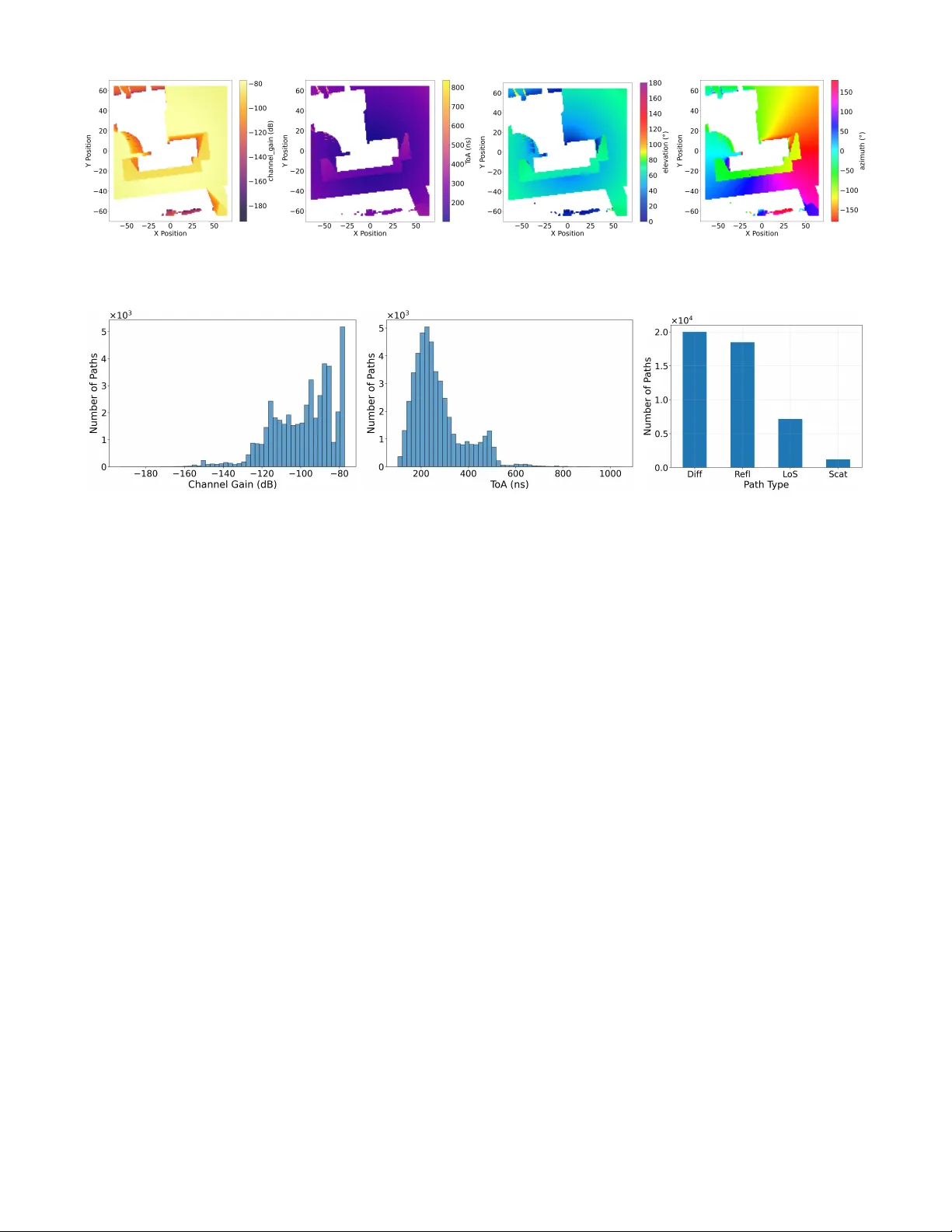
OpenP athNet: An Open-Source RF Multipath Data Generator for AI-Dri v en W ireless Systems Lizhou Liu, Xiaohui Chen, W enyi Zhang ∗ Department of Electronic Engineering and Information Science, Univ ersity of Science and T echnology of China, Hefei, Anhui 230027, China Email: liulizhou@mail.ustc.edu.cn; cxh@ustc.edu.cn; wenyizha@ustc.edu.cn Abstract —The con vergence of artificial intelligence (AI) and sixth-generation (6G) wireless technologies is driving an urgent need for large-scale, high-fidelity , and repr oducible radio fre- quency (RF) datasets. Existing resources, such as CKMImageNet, primarily provide preprocessed and image-based channel rep- resentations, which conceal the fine-grained physical character - istics of signal propagation that are essential for effective AI modeling. T o bridge this gap, we present OpenPathNet, an open- source RF multipath data generator accompanied by a publicly released dataset for AI-driven wireless research. Distinct from prior datasets, OpenPathNet offers disaggregated and physically consistent multipath parameters, including per-path gain, time of arrival (T oA), and spatial angles, derived from high-precision ray tracing simulations constructed on real-w orld envir onment maps. By adopting a modular , parameterized pipeline, OpenPathNet enables repr oducible generation of multipath data and can be readily extended to new en vironments and configurations, impro ving scalability and transparency . The released generator and accompanying dataset provide an extensible testbed that holds promise for advancing studies on channel modeling, beam prediction, en vironment-awar e communication, and integrated sensing in AI-enabled 6G systems. The source code and dataset are publicly available at https://github .com/liu- lz/OpenPathNet. Index T erms —Artificial intelligence (AI), dataset, envir onment- aware communication, multipath propagation, radio frequency (RF) map, ray tracing. I . I N T RO D U C T I O N In sixth-generation (6G) mobile communication networks, dense infrastructure deployment, large antenna arrays, wide bandwidths, and intelligent network architectures are antic- ipated to be defining technological features [1]. Accurately characterizing the spatial distrib ution and propagation behavior of radio frequency (RF) signals is crucial for extracting and utilizing channel state information (CSI). High-resolution RF maps enable efficient analysis and prediction of signal distri- butions, thereby playing a key role in enhancing the quality of service (QoS) of wireless communication systems. Howe ver , constructing a complete and accurate RF map remains a challenging task. T raditional empirical propagation models, such as the Okumura-Hata model [2], struggle to capture complex propag ation behaviors in urban en vironments. Ray tracing methods [3] achieve higher accuracy but require substantial computational resources, while interpolation-based This work was supported in part by the National Natural Science Foundation of China through Grant 62231022. Corresponding author: W enyi Zhang. approaches (e.g., Kriging [4]) are efficient yet prone to signif- icant errors under sparse or non-uniform sampling conditions. W ith the rapid advancement of artificial intelligence (AI), deep learning-based approaches for constructing RF maps ha ve attracted significant research interest. Recent methods, such as RadioUNet [5] and diffusion-based frameworks [6], have shown progress in predicting signal strength or path loss. Nev ertheless, these methods typically focus on a single phys- ical quantity and ov erlook the multipath effects that dominate wireless propagation. Fundamentally , multipath propagation determines signal fading, interference behavior , and spatial correlation. Sev eral studies ha ve explored this direction, such as [7], which constructed a multipath RF map, and [8], which lev eraged multipath information for high-precision localiza- tion. Despite these ef forts, there remains a scarcity of high- fidelity datasets capable of systematically representing multi- path characteristics. Existing public datasets [9] - [14] exhibit two primary limitations. First, they typically provide only aggregated channel responses or power distributions, often presented as image-based representations rather than the ex- plicit path-level multipath parameters essential for multiscale modeling and physical interpretability . Second, most datasets are released as static collections rather than parameterized generation frameworks, thereby constraining reproducibility and scalability . T o address these limitations, we present OpenPathNet as a configurable toolchain that, based on real-world en vironments, constructs simulation scenes and generates structured path- lev el multipath parameter sets through a unified and fully open workflo w . Lightweight configuration files further enable effi- cient data generation for new environments and varied deploy- ment settings (e.g., transceiv er placement, carrier frequency , and antenna parameters). Rather than releasing task-specific representations, the pipeline outputs explicit path-lev el chan- nel parameters, allowing researchers to construct customized inputs for different learning targets while retaining physical interpretability . Alongside the toolchain, we publicly release a reference dataset generated from representati ve real-world scenes using the proposed generator . Each sample provides explicit per-path physical parameters, including path gain, time of arriv al (T oA), and spatial angles. This combination of a released dataset and a configurable generator facilitates scalable multipath data construction and transparent reuse by the community . I I . R E L AT E D R F D A TA S E T S W ith the rapid integration of AI into wireless communi- cations, the demand for high-fidelity , large-scale RF datasets that accurately capture physical propagation characteristics has grown substantially . Recently , sev eral RF datasets tailored for AI-driv en research have emerged, playing a crucial role in advancing intelligent communication, sensing, and modeling. This section revie ws and analyzes representativ e RF datasets, examining their design concepts, strengths, and limitations, and subsequently outlining the motiv ation for dev eloping OpenPathNet. A. DeepMIMO DeepMIMO [9] is a highly flexible and parameterized dataset designed for deep learning research in wireless com- munications. It employs ray tracing simulations to generate realistic channel data, allowing researchers to configure a wide range of parameters, including antenna settings, system bandwidth, number of paths, carrier frequency , and user dis- tribution. This flexibility makes DeepMIMO a versatile tool for various tasks such as beam prediction, channel estimation, and localization. Notably , DeepMIMO provides rich RF in- formation, including detailed multipath components with their corresponding delay , gain, and angular characteristics for each propagation path. Ho wev er , a primary limitation is its reliance on a fixed set of predefined scenarios. Users are restricted to adjusting parameters within these provided en vironments, lacking the ability to import or construct customized scenes tailored to specific research needs.. B. RadioMapSeer RadioMapSeer [10] is a large-scale radio map dataset designed for dense urban environments. It provides high- quality RF propagation samples for deep learning research. The dataset is built on ray tracing simulations that gener- ate pathloss and T oA data across multiple city layouts and frequency bands. By adopting a vision-dri ven org anization strategy , RadioMapSeer con verts pathloss values into two- dimensional (2D) images, thereby lowering the modeling barrier and facilitating the use of computer vision models for propagation prediction. It also facilitates vision-based wireless learning. Howe ver , this design introduces limitations. Specifically , pathloss values are truncated and linearly scaled to 8-bit grayscale, a quantization process that restricts the dataset’ s utility for precise multidimensional modeling. When propagation characteristics are rasterized into pathloss maps, detailed multipath parameters, such as angular information and non-dominant path components, are lost. This hinders the anal- ysis of temporal and spatial structures. Finally , RadioMapSeer is a largely closed framework. As a static dataset, it does not support ne w en vironment customization or reproducible ray tracing configurations. Consequently , while it is well suited for macroscopic propagation modeling, it is less applicable to AI models requiring fine-grained, signal-lev el information. C. CKMImageNet CKMImageNet [11] reformulates channel prediction into a vision-based learning task by representing wireless propaga- tion en vironments as grayscale images. The approach enables wireless researchers to leverage deep neural architectures and training strategies from computer vision, thereby enhancing AI-driv en channel characterization and beam prediction. In terms of data div ersity , CKMImageNet covers a broad range of propagation scenarios, utilizing high-precision ray tracing to generate structured training and testing datasets. Howe ver , its reliance on image-based representations rather than explicit multipath parameters presents a significant limitation. The process of mapping high-dimensional multipath data into 2D images inevitably aggregates and quantizes physical details, constraining in-depth propagation analysis. Furthermore, CK- MImageNet is also not fully open source. The absence of complete modeling scripts and generation pipelines restricts researchers from customizing en vironments or adjusting pa- rameters. Consequently , while CKMImageNet serves as a valuable benchmark for vision-based channel learning, it is less suitable for studies requiring high reproducibility , scala- bility , and physical fidelity . D. RadioDiff-3D RadioDiff-3D [12] is a large-scale 3D radio map dataset providing pathloss, angle of departure (AoD), and T oA infor- mation via image-based representations. Unlike e xisting 2D datasets, it enables fully 3D channel modeling and supports altitude-aware wireless applications. Howe ver , RadioDiff-3D is generated under fixed simulation scenarios and parameter settings, which prev ents flexible extension to user-defined en vironments or custom propagation configurations. Further- more, access to the underlying physical channel parameters remains unav ailable. E. Sensiverse Sensiv erse [13] is a large-scale dataset dedicated to inte- grated sensing and communication (ISAC), of fering RF chan- nel samples, 3D en vironmental models, and scripts for multi- scenario simulations. Howe ver , its channel data is provided as channel frequency responses rather than explicit per-path multipath parameters. Additionally , it is released as a static dataset, limiting the flexibility for scenario customization. F . DeepSense 6G DeepSense 6G [14] is a real-measurement-based multi- modal sensing and communication dataset covering di verse real-world en vironments. Nevertheless, it provides only re- ceiv ed signal power on the communication side, lacking detailed multipath characteristics. Moreover , its reliance on complex data acquisition with specialized hardware platforms constrains both reproducibility and scalability . Based on the abov e analysis, existing RF datasets have played important roles in specific scenarios and tasks. How- ev er, they exhibit common intrinsic limitations that hinder broader support for AI-driv en wireless communication re- search. One fundamental issue lies in the granularity of data representation. Most datasets provide highly aggregated or post-processed channel information rather than explicit path- lev el multipath parameters. Such representations can obscure key physical details of propagation, making it difficult for AI models to directly relate environment geometry to discrete multipath components. Another critical limitation is the lack of flexibility regarding the data-generation process. Most existing datasets are released as static collections of pre-generated results, rather than open-source and parameterized generation framew orks. As a result, researchers are often unable to incorporate custom en vironments, adjust simulation settings, or systematically extend the data to new en vironments and configurations, which constrains reproducibility , scalability , and adaptability . T o address these gaps in data representation and framew ork openness, OpenPathNet is presented. I I I . D A TA S E T D E S I G N A N D G E N E R A T I O N F R A M E W O R K The core objective of OpenPathNet is to create a repro- ducible, scalable, and physically consistent frame work for gen- erating e xplicit path-le vel multipath data for AI-dri ven wireless communication research. Unlike con ventional datasets that rely on closed simulators or empirical channel models, Open- PathNet focuses on end-to-end interpretability and physical- model consistency . This focus allo ws researchers to system- atically ev aluate model generalization, adherence to physical principles, and rob ustness on a unified foundation. This section elaborates on the frame work’ s core modules and the automated pipeline enabling large-scale data generation. A. F rame work Overview and Design Principles OpenPathNet is built on three design pillars: geographical and parametric configurability , physical consistency , and re- producibility . It generates per-path radio frequency data, not just aggregated channel responses or image-based representa- tions. Unlike datasets that only provide channel gain or path loss, OpenPathNet preserves the fidelity and completeness of path-level observ ables such as complex gain, T oA, and multidimensional angular features. By minimizing reliance on empirical assumptions, such as stationarity or Gaussian approximations, the frame work offers physically grounded data for learning-based channel modeling, wireless sensing, and multimodal en vironmental understanding. Inspired by Geo2SigMap [15], we developed an automated toolchain that enables flexible and scalable scene construc- tion. Lev eraging this toolchain, OpenPathNet further adopts a modular architecture integrating three essential components: en vironment modeling, ray tracing simulation, and data pro- cessing. The en vironment modeling module supports both au- tomated import of city-scale 3D en vironments from geographic information systems and procedural synthesis of structured geometries, addressing div erse spatial coverage needs. Using automated scripts that combine OpenStr eetMap 1 and Blender 2 , 1 https://www .openstreetmap.org/ 2 https://www .blender .org/ users can seamlessly generate simulation-ready 3D scenes from real-world latitude and longitude coordinates. When geographical data are unav ailable, the framew ork enables procedural block generation through a parametric geometry engine, ensuring spatial continuity and statistical div ersity for large-scale synthesis. T o ensure physical consistency , the framew ork enforces constraints at both the modeling and simulation le vels. At the recei ver side, the region of interest is discretized into a 2D grid, and occluded or indoor points are automatically excluded via geometric visibility detection to prevent non- physical paths. At the propagation lev el, Sionna 3 is used to explicitly resolve the multipath set for each transceiver pair , incorporating line-of-sight (LoS), reflection, dif fraction, and scattering mechanisms. Each resolved path contains complex gain, T oA, angular features, and propagation type, supporting cross-scale and cross-scenario physical modeling consistency . Fig. 1 illustrates key intermediate steps of the workflo w for a location in New Y ork, including street-view imagery , 3D building distributions, and ray tracing simulations generated via OpenStr eetMap , Blender , and Sionna . (a) (b) (c) Fig. 1. For a location in New Y ork: (a) street-view image, (b) 3D building distribution, and (c) ray-tracing simulation. Both transmitters and receiv ers employ parameterized an- tenna models (e.g., isotropic radiators or vertically polarized dipoles), ensuring comparability across scenarios while fa- cilitating extensibility for directional array and polarization modeling. This flexible design allows seamless extension to beamforming, RIS-assisted, or MIMO-based systems. T o further guarantee reproducibility and scalability , Open- PathNet operates under a configuration-driv en mechanism where all hyperparameters are managed via unified files. Unlike con ventional static datasets, OpenPathNet functions as an open-source dynamic generator, empowering researchers to reproduce experiments or e xtend simulations to ne w city maps, frequency bands, and system configurations. Through this holistic framework, OpenPathNet achieves high-fidelity , path- lev el, and physically interpretable data generation, spanning from city geometry to multipath representation. B. Data Generation Pipeline and Implementation The data generation pipeline of OpenPathNet is illustrated in Fig. 2. A centralized Y AML configuration file specifies all 3 https://github .com/NVlabs/sionna Fig. 2. Data generation pipeline of OpenPathNet. essential hyperparameters, including carrier frequency , maxi- mum tracing depth, receiv er distribution, transceiv er heights, and antenna parameters. During the scene construction and geometric preprocessing stage, 3D urban models are generated either by importing real-world scenes based on geographic coordinates or by pro- cedurally synthesizing randomized scenes. The target area is then populated with a structured receiver (RX) grid. T o ensure geometric precision and computational efficienc y , acceleration structures utilizing Mitsuba are inte grated to detect and ex- clude points located within building meshes, retaining only visible outdoor receiv er points for propagation simulation. This preprocessing step significantly reduces computational ov erhead while maintaining the physical validity of samples. In the core ray tracing stage, the preprocessed scenes and transceiv er configurations are loaded into Sionna, which resolves complete multipath sets, covering LoS, reflection, diffraction, and scattering effects. For large-scale scenarios or GPU-constrained en vironments, OpenPathNet introduces an adaptive computation strategy where receiv er points are processed in batches. Upon detecting resource bottlenecks, the system dynamically modulates computational density (e.g., adjusting ray sampling count or tracing depth) while upholding a predefined physical fidelity threshold. This strategy greatly enhances stability and scalability in large-scale simulations, ensuring consistent outputs across div erse hardware setups. Complementing this algorithmic strategy , OpenPathNet em- ploys a dual-mode architecture that fully le verages parallel processing on high-performance GPUs while enabling flex- ible distributed computation on CPUs. This design ensures seamless compatibility ranging from individual workstations to large-scale cluster simulations. In the post-processing and export stage, ray tracing results for each receiv er point are refined. The strongest N paths (e.g., N = 5 ) are retained based on channel gain, and ke y parameters such as T oA, complex gain, and angles are normalized. T o cater to diverse research requirements, the framework supports multiple export formats, including CSV and Pickle for detailed analysis, NumPy (.npy) for rapid loading, and auto-generated visualizations for immediate quality inspection. Importantly , OpenPathNet is explicitly designed for cross- scenario transferability and algorithmic generalization. Lev er- aging a unified configuration, researchers can ef ficiently switch between urban scales, carrier frequencies, and antenna types to systematically ev aluate algorithm robustness across div erse propagation en vironments. In summary , through rigorous con- figuration management, geometric preprocessing, and robust ray tracing computation, OpenPathNet establishes a high- fidelity , scalable, and reproducible frame work, serving as a robust foundation for advancing AI-driv en wireless communi- cation research. I V . D A TA S E T C H A R A C T E R I S T I C S A N D A N A LY S I S This section provides an ov erview of the core structure, physical attributes, and statistical properties of the accom- panying dataset released with OpenP athNet. Unlike con ven- tional simulation-based datasets, it contains explicit path-le vel multipath parameters generated through realistic geographic modeling and physically consistent constraints. Crucially , the dataset is fully reproducible via the open and configurable OpenPathNet generation pipeline. The resulting large-scale multipath database supports realism, comparability , and scala- bility by preserving geometric fidelity at the macroscopic level while maintaining statistical consistency with electromagnetic propagation at the microscopic level. A. Envir onmental Information OpenPathNet emplo ys high-fidelity en vironmental modeling by reconstructing real-world spatial geometries and material characteristics to facilitate accurate ray tracing. En vironmental models are derived from actual city layouts, utilizing Blender and OpenStreetMap to extract building footprints and height profiles. The resulting 3D models incorporate detailed material attributes, such as concrete, glass, and metal, ensuring both geometric and physical realism. The accompanying dataset currently spans ov er ten repre- sentativ e cities, including Beijing, Shanghai, New Y ork, and London, comprising more than 12,000 independent simulation scenes. Each scene corresponds to a 128 m × 128 m block, sampled across tens of kilometers around city centers to achiev e dense tiling across core, transition, and suburban areas. This hierarchical sampling ensures spatial continuity and representativ eness on a city scale. Follo wing the unified generation protocol, all city subsets share identical configurations, including coordinate systems, geometric resolution, tracing depth, and physical parameters, thereby ensuring semantic comparability . Each scene is stored in .xml format, containing complete 3D geometry , material properties, surface reflectivity , and global coordinates. This format allo ws researchers to reproduce, e xtend, or annotate scenes for downstream tasks such as channel prediction or semantic labeling. In addition, OpenPathNet provides metadata for each scene, recording geographic coordinates, generation parameters, and ray tracing settings to facilitate efficient retriev al and repro- ducible analysis. Fig. 3(a) illustrates a real city environment, while Fig. 3(b) depicts a procedurally generated scene for comparison. B. P er-P ath Data A key innov ation of OpenPathNet is the inclusion of complete per-path channel parameters. Unlike aggregated or (a) (b) Fig. 3. Examples of building outlines: (a) real-world scenario, (b) randomly generated scenario. OpenPathNet/data/London/ generation_stats.txt generated_scenes.txt scenes/ scene_51.373364_-0.116620/ scene.xml mesh/ ground.ply building_0.ply building_1.ply ... ... raytracing_results/ scene_51.373364_-0.116620/ raytracing_results.csv raytracing_results.pkl deepmimo_format.npy outdoor_receivers.png channel_gain_distribution.png ToA_distribution.png path_type_distribution.png heatmaps/ channel_gain_heatmap.png ToA_heatmap.png elevation_heatmap.png azimuth_heatmap.png ... Fig. 4. Organizational structure of the dataset. channel-lev el datasets, OpenPathNet preserves detailed multi- path structures at each recei ver point, providing interpretable and reconstructable channel representations. In the current dataset configuration, all scenes use a trans- mitter at (0 , 0 , 30) with an omnidirectional antenna. Receivers are uniformly placed on a 128 × 128 grid with 1 m spacing at a height of 1 m, enabling dense spatial sampling. The data are stored within a standardized directory structure, as illustrated in Fig. 4. For each recei ver , OpenPathNet provides N path parameters including complex gain, T oA, AoD, angle of arriv al (AoA), and path type (LoS, reflection, dif fraction, or scattering). Spa- tial angles are standardized into azimuth ϕ ∈ [ − 180 ◦ , 180 ◦ ] and elev ation θ ∈ [0 ◦ , 180 ◦ ] to maintain consistency across different en vironments. T o enhance interpretability , OpenPathNet provides multi- modal visualization and statistical analyses. Fig. 5 presents the spatial distributions of gain, T oA, and the elev ation and azimuth angles of arriv al for the dominant path. Ideally , power and T oA exhibit radial gradients centered on the transmitter , while angular distributions form ring-like structures consistent with geometric propagation laws. These observations validate the dataset’ s physical accuracy and demonstrate its capability to capture spatial correlations in electromagnetic propagation, forming a reliable basis for geometry- and vision-based learn- ing tasks. Fig. 6 further illustrates the statistical distributions of key physical parameters in the current scenario. C. Cross-City V ariability and Utility All OpenPathNet city datasets are generated using identical protocols, physical parameters, and quality-control thresholds, including outdoor point filtering and a minimum sample density . This uniform standard ensures that statistical varia- tions across cities are attributable solely to urban morphology rather than implementation or parameter inconsistencies. Con- sequently , OpenPathNet enables systematic studies on the in- terplay between city geometry and propagation characteristics. Cross-city analyses indicate that the primary differences in multipath statistics arise from building density , street topology , and terrain. Highly dense cities, such as T okyo and New Y ork, exhibit multimodal distributions in path counts. These variations provide physically interpretable insights into ho w urban structures shape propagation characteristics. OpenPathNet supports two primary research paradigms: (i) Intra-City Stratified Analysis : analyzing path energy and angular statistics across different functional zones, road hierarchies, or density clusters; and (ii) Cross-City General- ization Analysis : comparing metrics such as LoS probability , delay spread, and angular concentration across cities under identical configurations to e valuate AI model generalization and robustness. Overall, OpenPathNet combines city-scale geometric con- straints with per-path physical fidelity to construct a unified multipath statistical profile. This dual-scale representation cap- tures both global propagation patterns and local variability , providing a credible foundation for multi-domain channel modeling, domain adaptation, and AI generalization bench- marking. V . C O N C L U S I O N In this paper , we presented OpenPathNet, an open-source, configuration-driv en frame work designed for scalable and re- producible RF multipath data generation, alongside a com- prehensiv e reference dataset deri ved from representative real- world en vironments. OpenPathNet addresses critical limita- tions in existing RF resources by offering explicit path-lev el multipath parameters and establishing a transparent, extensible generation pipeline. This design allows researchers to not (a) (b) (c) (d) Fig. 5. V isualization of the first-path parameters: (a) channel gain, (b) T oA, (c) elevation angle, and (d) azimuth angle. (a) (b) (c) Fig. 6. Example of path-lev el statistical results in a given scenario: (a) channel gain distribution, (b) T oA distribution, (c) path type distribution. only reproduce experiments but also systematically expand simulations to new en vironments and system configurations. Crucially , the framew ork ensures precise alignment between spatial geometry and propagation modeling, providing geomet- rically consistent en vironmental conte xts that mirror real-world structures. These explicitly parameterized outputs empo wer researchers to explore downstream applications, such as data- and-model-driv en RF map construction and ISAC. As such, OpenPathNet serves as a robust foundation for reproducible benchmarking in AI-enabled wireless research toward 6G. Future work will e xtend the framew ork’ s coverage to a broader range of cities and frequency bands, while incorporating dynamic en vironmental factors to capture fine-grained spa- tiotemporal variations. R E F E R E N C E S [1] Y . Zeng, et al., “ A tutorial on environment-a ware communications via channel knowledge map for 6G, ” IEEE Commun. Surveys T uts. , vol. 26, no. 3, pp. 1478-1519, 3rd Quart., 2024. [2] M. Hata, “Empirical formula for propagation loss in land mobile radio services, ” IEEE T rans. V eh. T echnol. , vol. 29, no. 3, pp. 317-325, Aug. 1980. [3] J. Hoydis, F . A. Aoudia, S. Cammerer, M. Nimier-Da vid, N. Binder , G. Marcus, and A. Keller , “Sionna RT : Dif ferentiable ray tracing for radio propagation modeling, ” arXiv preprint , 2023. [4] H. Braham, S. B. Jemaa, G. Fort, E. Moulines, and B. Sayrac, “Fixed rank Kriging for cellular cov erage analysis, ” IEEE T rans. V eh. T echnol. , vol. 66, no. 5, pp. 4212-4222, May 2017. [5] R. Levie, C. Y apar, G. Kutyniok, and G. Caire, “RadioUNet: fast radio map estimation with conv olutional neural networks, ” IEEE T rans. W ireless Commun. , vol. 20, pp. 4001-4015, Jun. 2021. [6] S. Fu, Z. Wu, D. Wu, and Y . Zeng, “Generativ e CKM construction using partially observed data with diffusion model, ” in 2025 IEEE 101st V ehicular T echnology Confer ence (VTC2025-Spring) , Oslo, Norway , Jun. 2025, pp. 1-5. [7] L. Liu, X. Chen, Z. T ang, M. Ma, and W . Zhang, “PINN and GNN- based RF Map Construction for W ireless Communication Systems, ” in 2025 International Confer ence on Future Communications and Networks (FCN) , Belgrade, Serbia, Aug. 2025, pp. 1-6. [8] Q. Li, X. Liao, A. Li, and S. V alaee, “ Automatic indoor radio map construction and localization via multipath fingerprint extrapolation, ” IEEE T rans. W ireless Commun. , vol. 22, no. 9, pp. 5814-5827, Sep. 2023. [9] A. Alkhateeb, “DeepMIMO: A generic deep learning dataset for mil- limeter wa ve and massive MIMO applications, ” in Proc. Inf. Theory Appli. W orkshop (ITA) , pp. 1-8, Feb . 2019. [10] C ¸ . Y apar , R. Le vie, G. Kutyniok, and G. Caire, “Dataset of pathloss and T oA radio maps with localization application, ” arXiv pr eprint arXiv:2212.11777 , 2022. [11] Z. Wu, D. Wu, S. Fu, Y . Qiu, and Y . Zeng, “CKMImageNet: A dataset for AI-based channel knowledge map towards environment- aware communication and sensing, ” IEEE T rans. Commun. , vol. 73, no. 12, pp. 14430-14443, Dec. 2025. [12] X. W ang, Q. Zhang, N. Cheng, J. Chen, Z. Zhang, Z. Li, S. Cui, and X. Shen, “RadioDif f-3D: A 3D × 3D radio map dataset and generativ e diffusion based benchmark for 6G en vironment-aware communication, ” IEEE T rans. Netw . Sci. Eng. , vol. 13, pp. 3773-3789, Dec. 2025. [13] J. Luo, B. Zhou, Y . Y u, P . Zhang, X. Peng, J. Ma, P . Zhu, J. Lu, and W . T ong, “Sensiv erse: A dataset for ISAC study , ” arXiv preprint arXiv:2308.13789 , 2023. [14] A. Alkhateeb, G. Charan, T . Osman, A. Hredzak, J. Morais, U. Demirhan, and N. Srinivas, “DeepSense 6G: A large-scale real-world multi-modal sensing and communication dataset, ” IEEE Commun. Mag. , vol. 61, no. 9, pp. 122-128, Sept. 2023. [15] Y . Li, Z. Li, Z. Gao, and T . Chen, “Geo2SigMap: High-fidelity RF signal mapping using geographic databases, ” in 2024 IEEE International Sym- posium on Dynamic Spectrum Access Networks (DySP AN) , W ashington, DC, USA, May 2024, pp. 277-285.
Original Paper
Loading high-quality paper...
Comments & Academic Discussion
Loading comments...
Leave a Comment