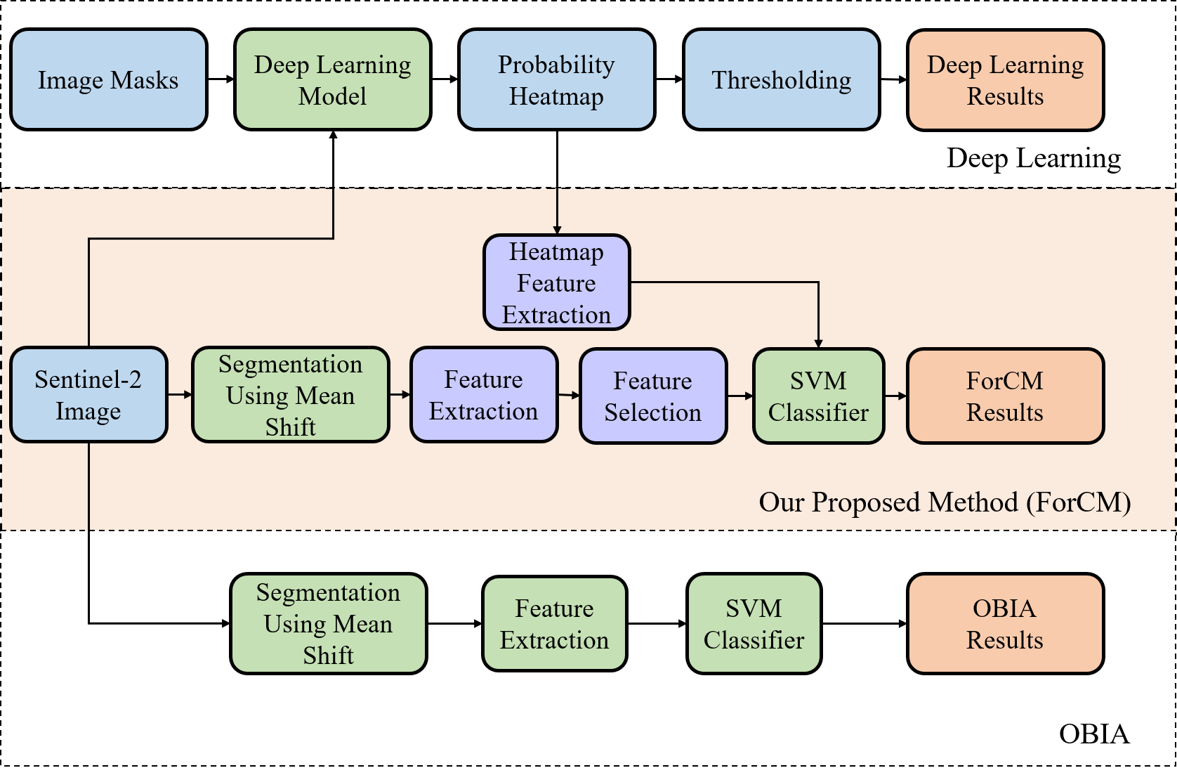
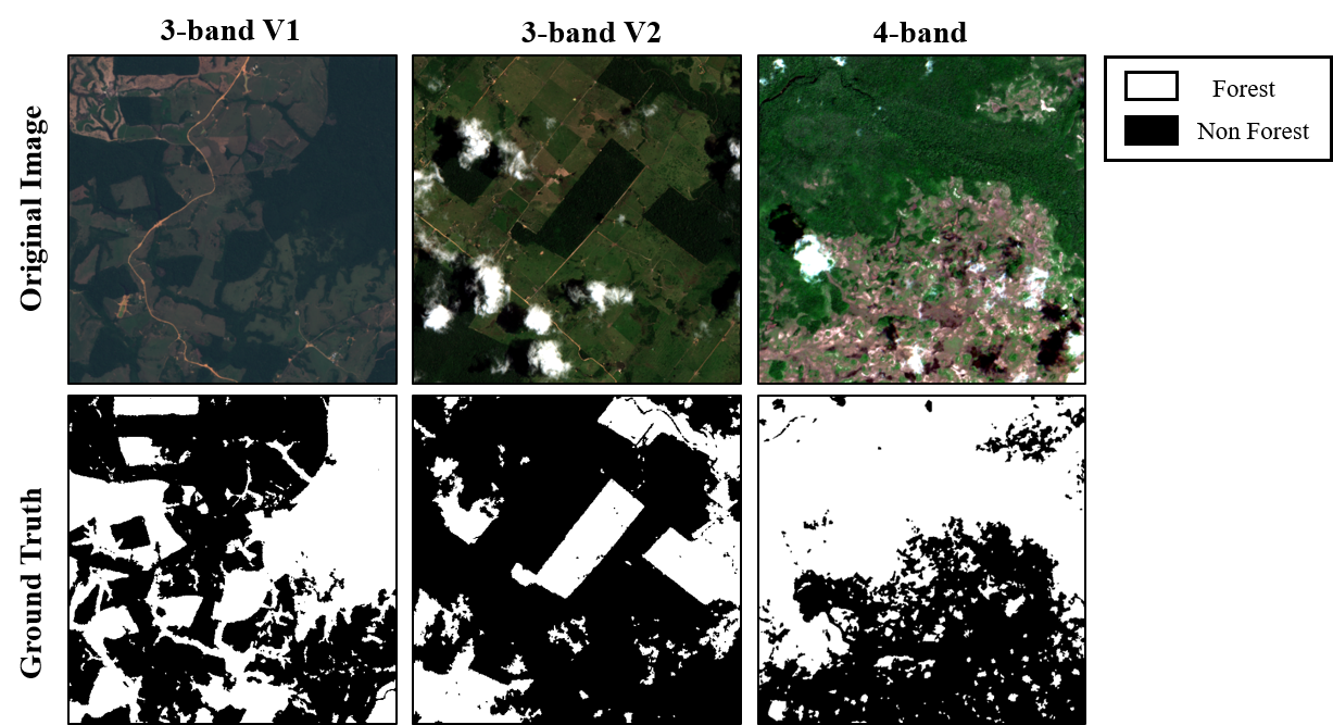
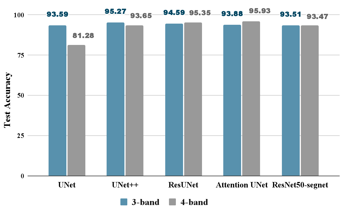
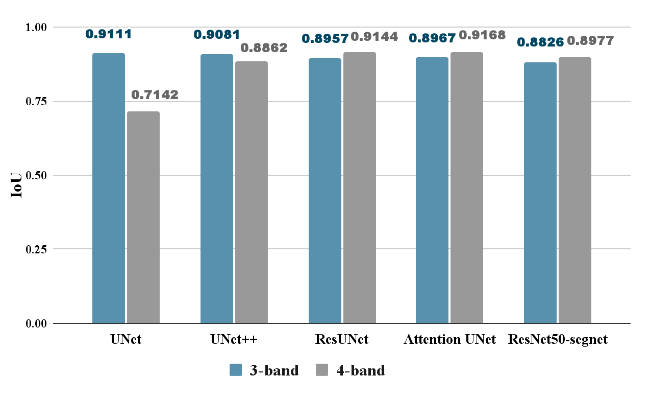
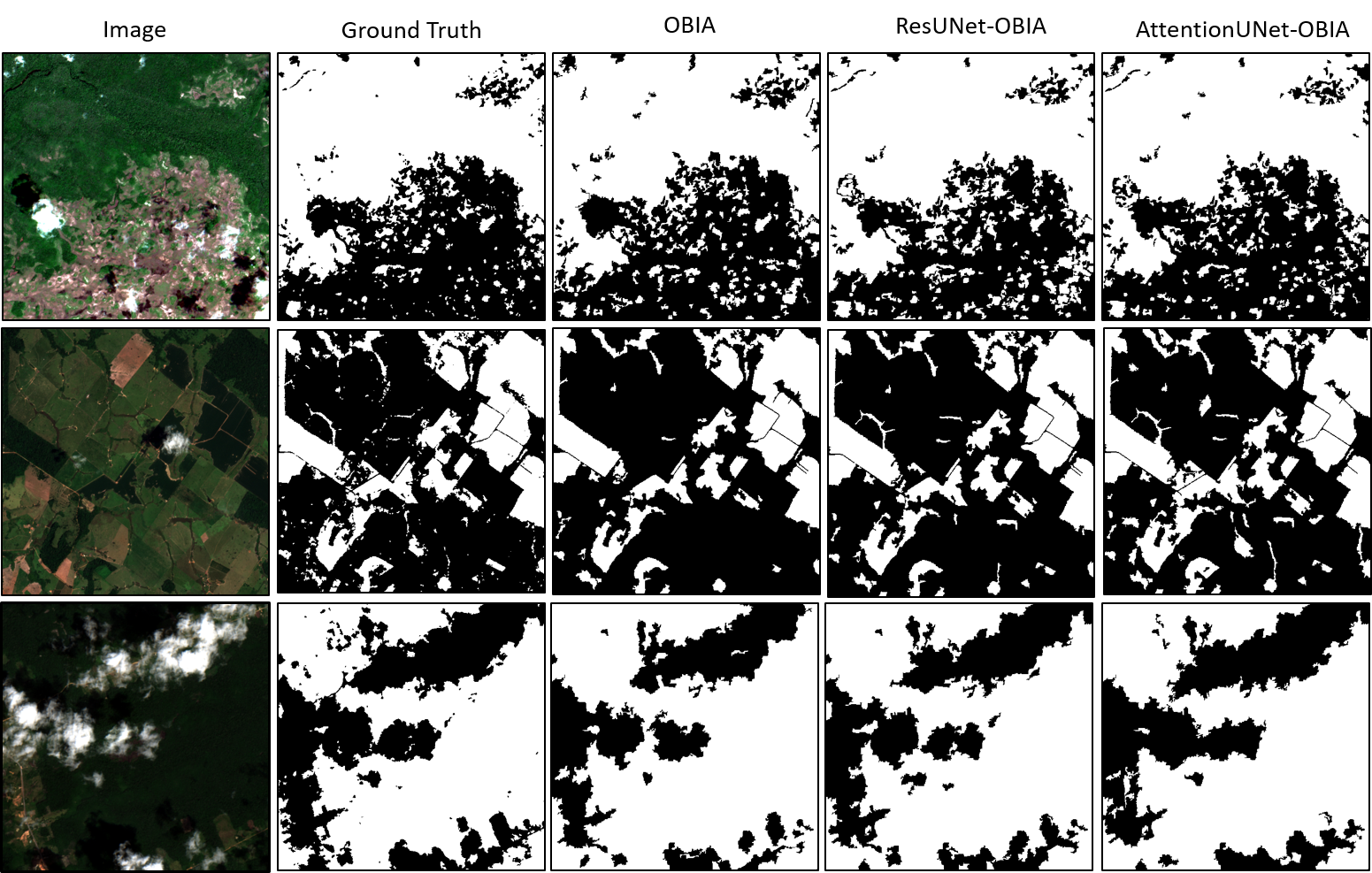
This research proposes "ForCM," a novel approach to forest cover mapping that combines Object-Based Image Analysis (OBIA) with Deep Learning (DL) using multispectral Sentinel-2 imagery. The study initially explores the application of several DL models such as UNet, UNet++, ResUNet, AttentionUNet, and ResNet50-Segnet-on high-resolution Sentinel-2 Level 2A satellite images of the Amazon Rainforest. The datasets comprise three primary collections: two sets of 3band imagery and one set of 4-band imagery. After evaluating the DL models, the most effective ones are individually integrated with the OBIA technique to enhance mapping accuracy. The originality of this work lies in the evaluation of different deep learning models combined with OBIA, and their comparison with traditional OBIA methods. The findings indicate that the proposed "ForCM" method significantly improves forest cover mapping, achieving overall accuracies of 94.54% with ResUNet-OBIA and 95.64% with AttentionUNet-OBIA, compared to 92.91% with the traditional OBIA approach. Furthermore, this research demonstrates the potential of free and user-friendly tools like QGIS for achieving precise mapping within their limitations, supporting global environmental monitoring and conservation efforts.
Deep Dive into ForCM: Forest Cover Mapping from Multispectral Sentinel-2 Image by Integrating Deep Learning with Object-Based Image Analysis.
This research proposes “ForCM,” a novel approach to forest cover mapping that combines Object-Based Image Analysis (OBIA) with Deep Learning (DL) using multispectral Sentinel-2 imagery. The study initially explores the application of several DL models such as UNet, UNet++, ResUNet, AttentionUNet, and ResNet50-Segnet-on high-resolution Sentinel-2 Level 2A satellite images of the Amazon Rainforest. The datasets comprise three primary collections: two sets of 3band imagery and one set of 4-band imagery. After evaluating the DL models, the most effective ones are individually integrated with the OBIA technique to enhance mapping accuracy. The originality of this work lies in the evaluation of different deep learning models combined with OBIA, and their comparison with traditional OBIA methods. The findings indicate that the proposed “ForCM” method significantly improves forest cover mapping, achieving overall accuracies of 94.54% with ResUNet-OBIA and 95.64% with AttentionUNet-OBIA, compar
ForCM: Forest Cover Mapping from
Multispectral Sentinel-2 Image by Integrating
Deep Learning with Object-Based Image Analysis
Maisha Haque1,∗, Israt Jahan Ayshi1, Sadaf M. Anis1, Nahian Tasnim1,
Mithila Moontaha1, Md. Sabbir Ahmed1, Muhammad Iqbal Hossain1,
Mohammad Zavid Parvez2,8,∗, Subrata Chakraborty3,4,5,∗, Biswajeet
Pradhan4,6, and Biswajit Banik7
1 BRAC University, Bangladesh
2 School of Computing, Mathematics and Engineering, Charles Sturt University,
Australia
3 School of Science and Technology, University of New England, Armidale, NSW
2351, Australia
4 Centre for Advanced Modelling and Geospatial Information Systems (CAMGIS),
School of Civil and Environmental Engineering, Faculty of Engineering & IT,
University of Technology Sydney, Sydney, NSW 2007, Australia
5 Griffith Business School, Griffith University, Nathan, QLD 4111, Australia
6 Earth Observation Centre, Institute of Climate Change, Universiti Kebangsaan
Malaysia (UKM), Bangi 43600, Selangor, Malaysia
7 Institute of Health and Wellbeing, Federation University Australia, Victoria,
Australia
8 School of Accounting, Information Systems and Supply Chain, RMIT University,
Australia
Abstract. This research proposes "ForCM," a novel approach to for-
est cover mapping that combines Object-Based Image Analysis (OBIA)
with Deep Learning (DL) using multispectral Sentinel-2 imagery. The
study initially explores the application of several DL models such as
UNet, UNet++, ResUNet, AttentionUNet, and ResNet50-Segnet—on
high-resolution Sentinel-2 Level 2A satellite images of the Amazon Rain-
forest. The datasets comprise three primary collections: two sets of 3-
band imagery and one set of 4-band imagery. After evaluating the DL
models, the most effective ones are individually integrated with the OBIA
technique to enhance mapping accuracy. The originality of this work lies
in the evaluation of different deep learning models combined with OBIA,
and their comparison with traditional OBIA methods. The findings in-
dicate that the proposed "ForCM" method significantly improves forest
cover mapping, achieving overall accuracies of 94.54% with ResUNet-
OBIA and 95.64% with AttentionUNet-OBIA, compared to 92.91% with
the traditional OBIA approach. Furthermore, this research demonstrates
the potential of free and user-friendly tools like QGIS for achieving pre-
cise mapping within their limitations, supporting global environmental
monitoring and conservation efforts.
arXiv:2512.23196v1 [cs.CV] 29 Dec 2025
2
M. Haque et al.
Keywords: Deep Learning · OBIA · Forest Mapping · ResUNet-OBIA
· AttentionUNet-OBIA.
1
Introduction
Forests provide crucial ecological services, including carbon sequestration, air
quality improvement, biodiversity protection and climate regulation. However,
global forestry ecosystems are consistently being threatened by deforestation
caused by non-eco-friendly human activities, urbanization, natural calamities,
climate change, and wildfires. Sustainable forest management must be admin-
istered to safeguard human survival and environmental stability. A key aspect
of forest administration strategies is the accurate mapping and monitoring of
forest cover, which is critical for mitigating the negative effects of deforestation.
Sentinel-2 satellite imagery is widely used in fields of forest cover mapping
including tropical forests [8], mangrove cover [21], as well as land cover classifi-
cation [24] for their multispectral bands. Current approaches to mapping forest
cover areas are mostly pixel-based and object-based. Object-Based Image Anal-
ysis (OBIA) is well known for its ability to improve segmentation by grouping
pixels into meaningful objects compared to pixel-based approaches. Conversely,
pixel-based approaches mostly involve machine learning and deep learning archi-
tectures, which are well-known for their ability to recognize pixel-level complex
patterns and extract relevant features but may struggle with precise object edges.
Even with their advancements, current forest cover mapping approaches face
some challenges. They can be costly and inconsistent and the results may vary
depending on the analyst’s expertise. Additionally, present methods often face
difficulty in reliably detecting and classifying subject edges. Concerning our re-
search scope of forest mapping, such issues can particularly commence in com-
plex landscapes with high occlusion and overlapping canopies. Previous studies
have employed OBIA [23] and machine learning (ML) [8, 9] or DL techniques
for example- using ML with manual refinement [21] or using deep learning tech-
niques [12,15]. Exploring such studies, their findings and limitations, it can be
deduced that the effectiveness of OBIA is heavily dependent on unambiguous
superior-quality input images and the segmentation procedure, which can lead
to overpredicting or underpredicting occasionally in certain scenarios, may it be
related to ambiguous input images or the complexity of used architectures. Ad-
ditionall
…(Full text truncated)…
This content is AI-processed based on ArXiv data.