Climate-driven reductions in Arctic sea-ice extent have renewed interest in trans-Arctic shipping, yet adoption remains limited by questions of route feasibility, safety, and excess distance. Existing work often compares idealised great-circle shortcuts or uses detailed weather-routing systems that couple metocean forcing, sea ice and ship performance, leaving a gap for basin-scale diagnostics on realistic bathymetry and sea-ice fields. We develop an offline graph-based framework for trans-Arctic route feasibility on a 0.5 • pan-Arctic grid that combines General Bathymetric Chart of the Oceans (GEBCO) 2024 bathymetry with a summer 2018 Arctic sea-ice reanalysis from the Copernicus Marine Environment Monitoring Service (CMEMS). Bathymetry is regridded to construct sea-only and depth-feasibility masks, while daily sea-ice concentration (SIC) fields define ice-feasibility masks. An A* pathfinding algorithm is applied to a canonical Europe-Asia origin-destination pair to
Deep Dive into 극지 해빙 감소와 트랜스아크틱 항로 가능성 평가 그래프 기반 오프라인 경로 탐색.
Climate-driven reductions in Arctic sea-ice extent have renewed interest in trans-Arctic shipping, yet adoption remains limited by questions of route feasibility, safety, and excess distance. Existing work often compares idealised great-circle shortcuts or uses detailed weather-routing systems that couple metocean forcing, sea ice and ship performance, leaving a gap for basin-scale diagnostics on realistic bathymetry and sea-ice fields. We develop an offline graph-based framework for trans-Arctic route feasibility on a 0.5 • pan-Arctic grid that combines General Bathymetric Chart of the Oceans (GEBCO) 2024 bathymetry with a summer 2018 Arctic sea-ice reanalysis from the Copernicus Marine Environment Monitoring Service (CMEMS). Bathymetry is regridded to construct sea-only and depth-feasibility masks, while daily sea-ice concentration (SIC) fields define ice-feasibility masks. An A* pathfinding algorithm is applied to a canonical Europe-Asia origin-destination pair to
Growing interest in decarbonisation, shifting trade patterns and declining Arctic sea-ice extent have renewed attention to high-latitude shipping corridors linking northern Europe and northeast Asia (Stroeve et al., 2012;Notz and Stroeve, 2016). Trans-Arctic options such as the Northern Sea Route (NSR) and related passages are often presented as 30-40% "shortcuts" relative to traditional Suez route, with implied savings in time, fuel and CO 2 emissions (Melia et al., 2016). At the same time, regulatory uncertainty, sparse infrastructure and safety concerns have so far limited large-scale commercial uptake (Stephenson et al., 2013;Chen et al., 2021).
A growing body of research has examined different aspects of Arctic route feasibility and potential, but important gaps remain at basin scale under explicit bathymetry and sea-ice constraints. One strand uses climate model projections and simple sea-ice indices to map potential future Arctic navigability, typically in terms of seasonal windows or navigable fractions of predefined corridors (Stephenson et al., 2013;Melia et al., 2016;Aksenov et al., 2017;Chen et al., 2021;Zhang et al., 2023). These studies highlight the strong sensitivity of Arctic shipping potential to greenhouse-gas scenarios and ice thresholds, but usually do not construct explicit ship routes on realistic coastal and bathymetric grids. A second strand focuses on detailed techno-economic assessments along specific Arctic routes, combining assumed voyage distances with fuel, emissions and cost models to compare NSR and Suez itineraries under various ice and regulatory regimes (Zhu et al., 2018;Pruyn and van Hassel, 2022). A third strand embeds sea-ice and metocean information directly in operational weather-routing or ship-ice interaction tools, coupling environmental forcing with vessel performance and optimisation algorithms to produce case-specific routes or risk metrics (Kuuliala et al., 2017;Lu et al., 2021;Liu et al., 2023). While powerful, such systems are often complex and vessel-specific, making them less suited to transparent, basin-scale diagnostics.
Beyond these strands, many corridor-scale comparisons between Arctic and traditional Europe-Asia routes still rely on great-circle or waypointbased sea-only distances to infer changes in voyage time, fuel consumption and CO 2 emissions between NSR, Suez and Cape of Good Hope baselines. In most such studies, route feasibility is handled implicitly through the placement of waypoints, without explicit bathymetric or sea-ice safety masks. From the perspective of end-users such as shipowners, cargo interests and policy analysts, there remains a need for simpler, physically grounded diagnostics that answer two prior questions: (i) does a continuous trans-Arctic connection exist at all under basic depth and ice criteria, and (ii) if so, what is the associated distance penalty relative to a great-circle lower bound?
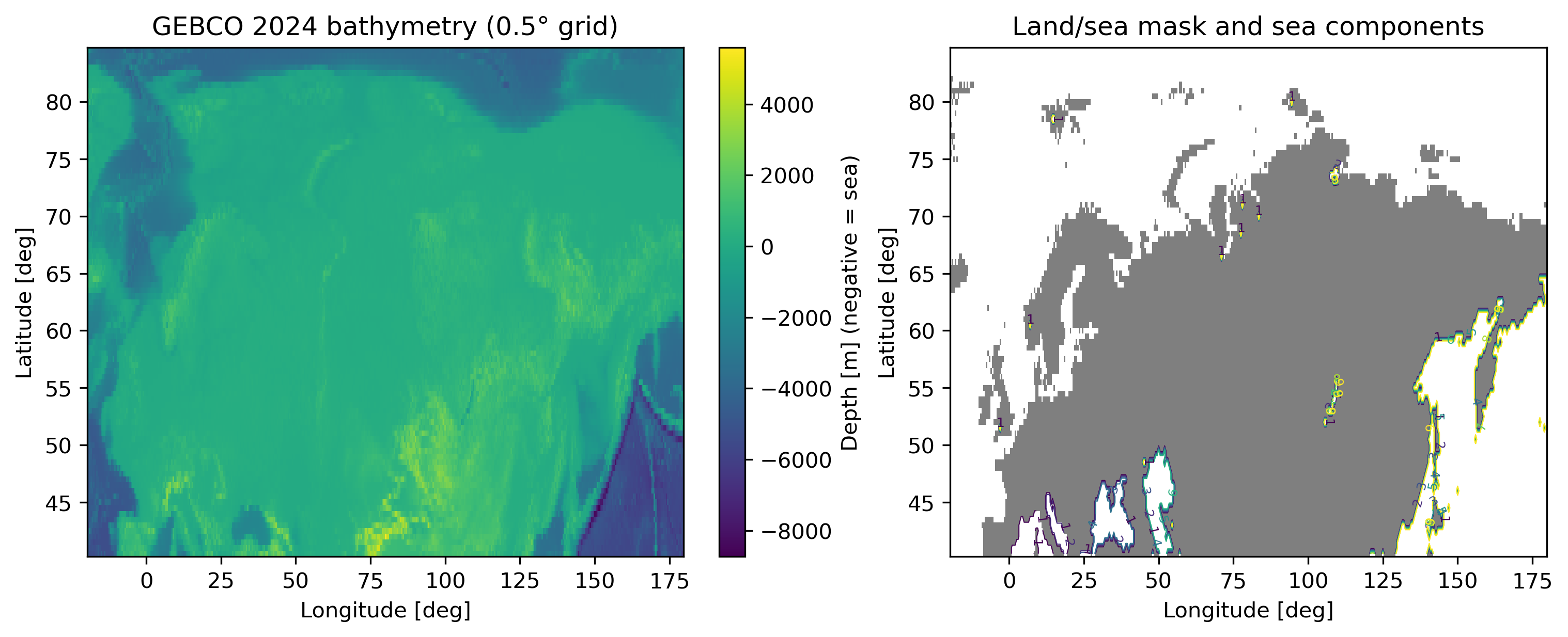
This paper aims to bridge part of that gap by developing an offline, graphbased routing framework for historical trans-Arctic route diagnostics under explicit bathymetric and sea-ice constraints. We consider a pan-Arctic corridor from 40 • N to 85 • N and 20 • W to 180 • E discretised at 0.5 • resolution, and combine GEBCO 2024 bathymetry with a daily Arctic sea-ice concentration (SIC) reanalysis from the Copernicus Marine Environment Monitoring Service (CMEMS) for the June-September 2018 season. A canonical Europe-Asia origin-destination pair is chosen to span the basin without tying the analysis to particular ports, in line with recent work emphasising generic corridor diagnostics over case-specific itineraries (Zhang et al., 2023). On this grid we construct sea-only, depth-constrained, ice-constrained and joint depth-plus-ice feasibility masks, and apply an A* pathfinding algorithm to quantify route availability, distance and excess length relative to great-circle baselines.
The analysis is intentionally restricted to static bathymetry and summer 2018 SIC fields, without metocean forcing, forecasts or vessel-specific performance models. This keeps the framework simple enough for exhaustive seasonal and threshold-sensitivity experiments, and positions the results as an envelope of what is theoretically possible under idealised operational behaviour. At the same time, the use of realistic coastlines, modern bathymetry and regridded sea-ice fields ensures that the diagnostics reflect key physical constraints on large-scale Arctic shipping rather than purely geometric great-circle arguments. The formulation is intended to complement, rather than compete with, more detailed operational weather-routing and technoeconomic tools.
More concretely, we address the following questions:
- How much does enforcing strict sea-only feasibility on a realistic bathymetric grid increase trans-Arctic route length relative to a great-circle baseline? 2. To what extent do simple depth thresholds, representing under-keel clearance for deep-draught
…(Full text truncated)…
This content is AI-processed based on ArXiv data.