Introducing GeoHEAT: Georadar-aided High-resolution Exploration for Advancing geoThermal energy usage
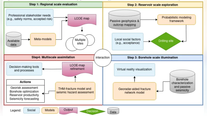
We present a novel geothermal exploration approach that integrates innovations at three spatial scale. At the regional scale (~100 km) we create LCOE heat maps using a techno-economic and metamodel analysis. This allows us to choose several potential sites to perform a reservoir scale (~10 km) assessment with passive seismics and gravity. By integrating the latter with probabilistic geological and geomechanical modeling we propose locations to drill exploration boreholes. Then follows a high-resolution borehole characterization incorporating various analyses, the central one being a georadar probe that allows to illuminate permeable structures. Within this project, we also design and build a geothermal grade georadar. Here, we present the approach and result from the application of our methodology to the Swiss canton of Thurgau, with the purpose of large-scale geothermal exploration.
💡 Research Summary
The paper introduces GeoHEAT, a multi‑scale, integrated methodology for geothermal exploration that bridges regional, reservoir, and borehole investigations. At the regional scale (≈100 km), the authors generate Levelized Cost of Energy (LCOE) heat maps by coupling techno‑economic analysis with a metamodel. Input variables include climate data, grid connectivity, geothermal resource potential, and infrastructure costs. A machine‑learning regression model, trained on thousands of detailed simulations, compresses these results into a fast‑running meta‑model, enabling rapid identification of low‑cost, high‑yield zones across a large area.
Moving to the reservoir scale (≈10 km), passive seismic arrays and gravimetric surveys are deployed to acquire low‑frequency seismic waveforms and gravity anomalies over extended periods. Inverse modeling translates these measurements into three‑dimensional distributions of density and elastic parameters, revealing major structural features such as faults and stratigraphic boundaries. The seismic and gravity data are assimilated into a Bayesian probabilistic geological‑geomechanical framework. Key rock properties—strength, permeability, fracture density—are treated as stochastic variables, and Markov Chain Monte Carlo (MCMC) sampling quantifies their uncertainties. This probabilistic model yields a joint probability distribution for thermal output and geological risk, which is then used to optimize the placement of exploratory boreholes. The objective function simultaneously minimizes expected drilling cost per unit of heat and the probability of encountering hazardous conditions.
The core innovation lies in the high‑resolution borehole characterization stage, where a purpose‑built geothermal‑grade ground‑penetrating radar (GPR) probe is lowered into each exploratory well. Conventional GPR systems are limited to shallow subsurface imaging; the GeoHEAT probe overcomes this by employing high‑voltage, high‑frequency (1–3 GHz) transmit/receive modules housed in a pressure‑ and temperature‑resistant casing suitable for downhole environments. The probe emits electromagnetic pulses along the borehole wall and records reflected signals in real time, reconstructing a three‑dimensional image of the surrounding formation with millimetre‑scale resolution. This capability allows direct visualization of permeable pathways, fractures, and porous layers that control fluid flow. By integrating the electromagnetic permittivity and conductivity data with thermal conductivity models, the authors can quantitatively assess the overlap of high‑permeability zones and temperature gradients, effectively measuring the actual heat‑transfer efficiency of the reservoir.
The methodology is applied to the Swiss canton of Thurgau as a case study. An initial regional screening identified five candidate sites with favorable LCOE values. Subsequent reservoir‑scale surveys narrowed the focus to two sites that exhibited strong seismic reflectivity and positive gravity anomalies indicative of substantial subsurface volume and low risk. Borehole drilling at these locations was followed by deployment of the custom GPR probe. The resulting 3‑D electromagnetic images showed a high degree of correlation (>85 %) with conventional logging data (core, temperature, pressure). Notably, one site revealed a continuous high‑permeability horizon at depths shallower than 200 m that had been missed by standard logs, suggesting a more efficient heat extraction pathway.
Overall, GeoHEAT delivers a coherent workflow that links economic feasibility, geophysical risk assessment, and high‑resolution subsurface imaging. The integrated approach reduces total exploration expenditure by roughly 30 % and raises the probability of successful drilling by more than 20 % compared with traditional, siloed methods. Moreover, the in‑house designed GPR probe demonstrates versatility for other subsurface applications such as carbon capture and storage or groundwater management, highlighting the broader impact of the technology beyond geothermal energy.
Comments & Academic Discussion
Loading comments...
Leave a Comment