Satellite-Net: Automatic Extraction of Land Cover Indicators from Satellite Imagery by Deep Learning
In this paper we address the challenge of land cover classification for satellite images via Deep Learning (DL). Land Cover aims to detect the physical characteristics of the territory and estimate the percentage of land occupied by a certain category of entities: vegetation, residential buildings, industrial areas, forest areas, rivers, lakes, etc. DL is a new paradigm for Big Data analytics and in particular for Computer Vision. The application of DL in images classification for land cover purposes has a great potential owing to the high degree of automation and computing performance. In particular, the invention of Convolution Neural Networks (CNNs) was a fundament for the advancements in this field. In [1], the Satellite Task Team of the UN Global Working Group describes the results achieved so far with respect to the use of earth observation for Official Statistics. However, in that study, CNNs have not yet been explored for automatic classification of imagery. This work investigates the usage of CNNs for the estimation of land cover indicators, providing evidence of the first promising results. In particular, the paper proposes a customized model, called Satellite-Net, able to reach an accuracy level up to 98% on test sets.
💡 Research Summary
The paper presents Satellite‑Net, a lightweight convolutional neural network (CNN) designed to automatically extract land‑cover indicators from satellite imagery. Leveraging the publicly available Sentinel‑2A based EuroSAT dataset, which contains 27,000 RGB images of size 64 × 64 pixels across ten land‑cover classes, the authors split the data into 80 % training, 10 % validation, and 10 % testing subsets. Satellite‑Net’s architecture consists of four convolutional layers, three max‑pooling layers, six ReLU activation layers, three batch‑normalization layers, three dropout layers (drop probability = 0.5), a flattening layer, two dense layers, and a final softmax classifier. To compensate for the modest dataset size, extensive data augmentation is applied: random zoom (0.8–1.2), rotation (0–30°), horizontal and vertical flips. Training is performed with the Adam optimizer (learning rate = 0.01, batch size = 32) for 300 epochs on an NVIDIA GTX‑1080 GPU, taking roughly 35 seconds per epoch.
The model achieves a test accuracy of 98.22 % on a held‑out set of 2,700 images (270 per class), with a confusion matrix indicating high precision and recall across most categories. Compared to prior work, Satellite‑Net reaches comparable performance while using fewer parameters and less computational time, demonstrating the feasibility of a lean yet powerful solution for remote‑sensing classification tasks. A simple graphical user interface (GUI) built with Python’s Tkinter library provides four buttons for importing images, training the model, classifying tiles, and generating land‑cover statistics, making the system accessible to non‑technical users.
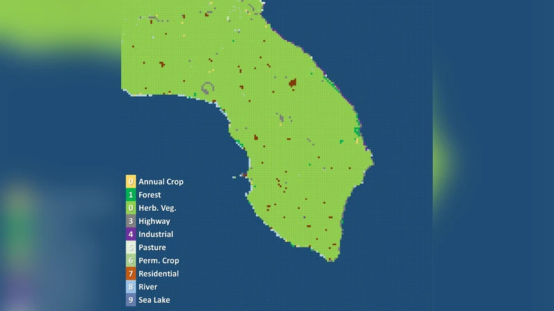
To address real‑world deployment, the authors implement a sliding‑window scanning routine that partitions large high‑resolution satellite images into non‑overlapping 64 × 64 tiles (stride = 64). Each tile is classified independently, and the resulting label map is reassembled to form a full‑size land‑cover map. The paper illustrates this workflow on a Sentinel‑2A image of the Puglia region in Italy (10,980 × 10,980 pixels), which yields a 171 × 171 classification matrix. By counting the frequency of each class label, raw land‑cover percentages are derived (e.g., sea/lake = 65.01 %, herbaceous vegetation = 33.40 %). The authors note that these raw figures include water bodies and must be post‑processed—either by cropping the image or masking sea tiles via GIS tools—to obtain accurate land‑cover shares for specific categories such as highways or residential areas.
In the conclusion, the authors reaffirm that CNNs are effective for remote‑sensing labeling and that Satellite‑Net delivers high accuracy with a compact architecture. They acknowledge that the current evaluation is limited to the EuroSAT benchmark and propose future work involving external validation on labeled aerial photographs of the Italian territory, integration of multispectral or SAR data, and scaling the system within national statistical production pipelines. Overall, the study contributes a practical, high‑performance tool for automated land‑cover extraction, offering a promising avenue for statistical agencies, urban planners, and environmental monitoring programs.
Comments & Academic Discussion
Loading comments...
Leave a Comment