📝 Original Info
- Title: 열에 민감한 보행 경로 탐색을 위한 핫헴 워크플로우
- ArXiv ID: 2512.11896
- Date: 2023-12-01
- Authors: Tess Vu, Xiaojiang Li ###
📝 Abstract
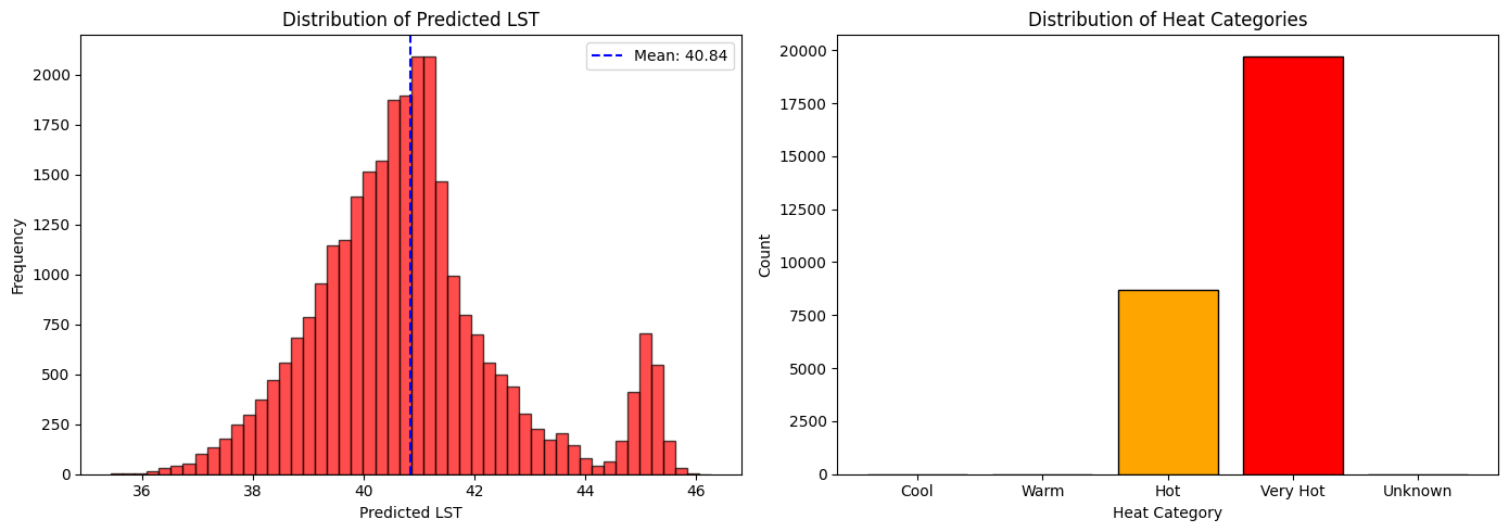
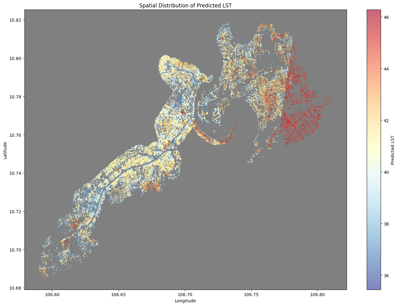
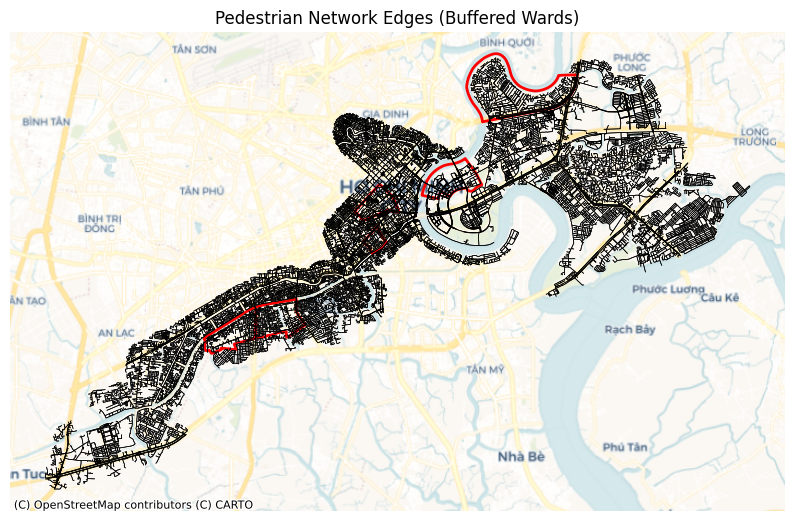
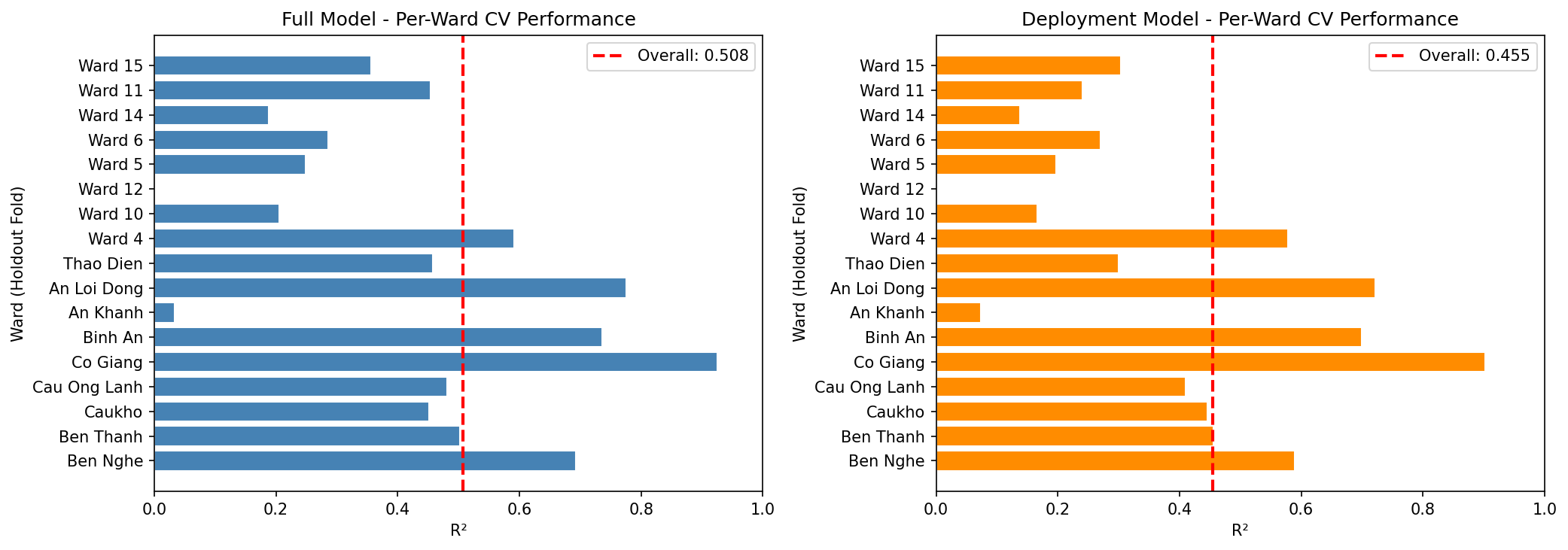
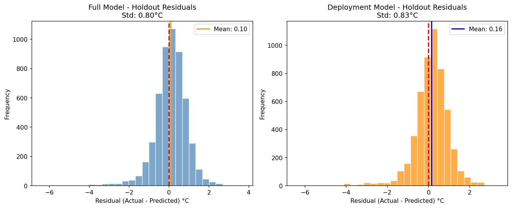
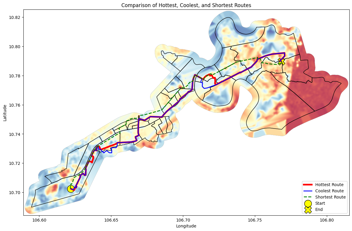
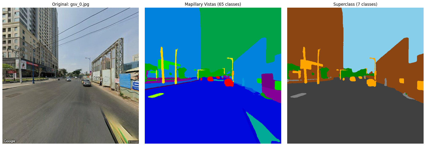
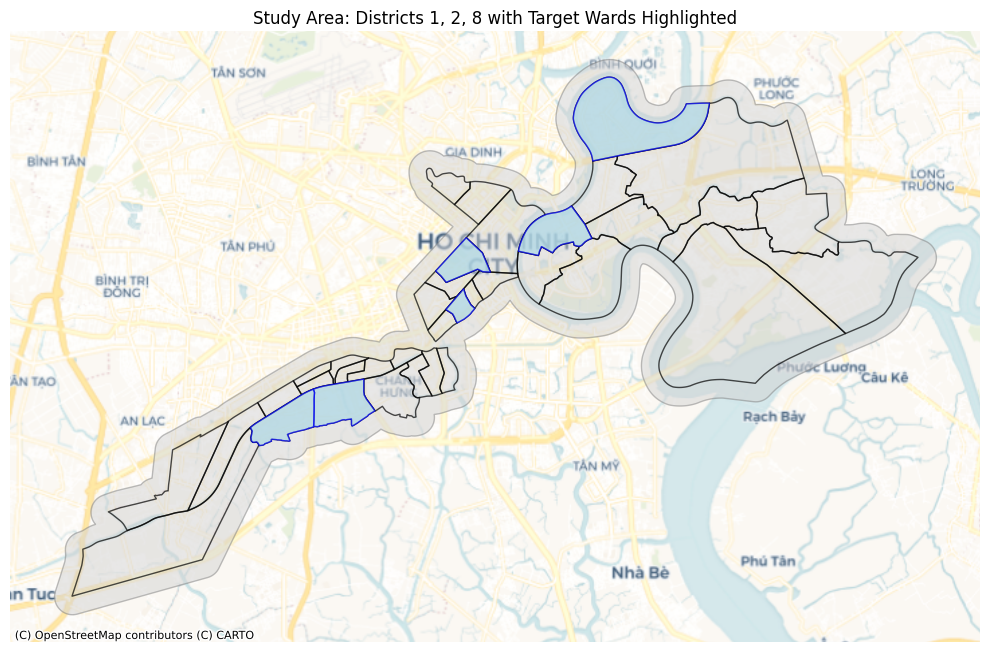
Pedestrian heat exposure is a critical health risk in dense tropical cities, yet standard routing algorithms often ignore micro-scale thermal variation. Hot Hẻm is a GeoAI workflow that estimates and operationalizes pedestrian heat exposure in Hồ Chí Minh City (HCMC), Việt Nam, colloquially known as Sài Gòn. This spatial data science pipeline combines Google Street View (GSV) imagery, semantic image segmentation, and remote sensing. Two XGBoost models are trained to predict land surface temperature (LST) using a GSV training dataset in selected administrative wards, known as phường, and are deployed in a patchwork manner across all OSMnx-derived pedestrian network nodes to enable heat-aware routing. This is a model that, when deployed, can provide a foundation for pinpointing where and further understanding why certain city corridors may experience disproportionately higher temperatures at an infrastructural scale.
💡 Deep Analysis
Deep Dive into 열에 민감한 보행 경로 탐색을 위한 핫헴 워크플로우.
Pedestrian heat exposure is a critical health risk in dense tropical cities, yet standard routing algorithms often ignore micro-scale thermal variation. Hot Hẻm is a GeoAI workflow that estimates and operationalizes pedestrian heat exposure in Hồ Chí Minh City (HCMC), Việt Nam, colloquially known as Sài Gòn. This spatial data science pipeline combines Google Street View (GSV) imagery, semantic image segmentation, and remote sensing. Two XGBoost models are trained to predict land surface temperature (LST) using a GSV training dataset in selected administrative wards, known as phường, and are deployed in a patchwork manner across all OSMnx-derived pedestrian network nodes to enable heat-aware routing. This is a model that, when deployed, can provide a foundation for pinpointing where and further understanding why certain city corridors may experience disproportionately higher temperatures at an infrastructural scale.
📄 Full Content
Hot Hẻm: Sài Gòn Giữa Cái Nóng Hổng
Công Bằng—Saigon in Unequal Heat
Optimization for Suffering: The Hottest Route Available
Tess Vu
Master of Urban Spatial Analytics
Stuart Weitzman School of Design
University of Pennsylvania
Philadelphia, PA 19104, USA
tessavu@upenn.edu
December 9, 2025
Abstract
Pedestrian heat exposure is a critical health risk in dense tropical cities,
yet standard routing algorithms often ignore micro-scale thermal variation.
Hot Hẻm is a GeoAI workflow that estimates and operationalizes pedestrian
heat exposure in HồChí Minh City (HCMC), Việt Nam, colloquially known
as Sài Gòn. This spatial data science pipeline combines Google Street View
(GSV) imagery, semantic image segmentation, and remote sensing.
Two
XGBoost models are trained to predict land surface temperature (LST)
using a GSV training dataset in selected administrative wards, known as
phường, and are deployed in a patchwork manner across all OSMnx-derived
pedestrian network nodes to enable heat-aware routing. This is a model that,
when deployed, can provide a foundation for pinpointing where and further
understanding why certain city corridors may experience disproportionately
higher temperatures at an infrastructural scale.
Keywords: GeoAI, Ho Chi Minh City, Saigon, Vietnam, XGBoost, data sci-
ence, environmental justice, geospatial, machine learning, pedestrian routing,
spatial, street view imagery, thermal mapping, urban analytics, urban heat is-
land
1
Introduction
Given that urban heat and other environmental injustices are widely recog-
nized as being disproportionately felt [1], dangerous heat exposure will only
continue to exacerbate with growing populations and current pollution trajecto-
ries. Extreme heat is heterogeneous and driven by both macro-scale morpholo-
1
arXiv:2512.11896v1 [cs.CV] 10 Dec 2025
gies (e.g., elevation, land cover, surface emissivity) and micro-scale streetscapes
(e.g., building canyon effects, tree canopy, visible sky) [2], many of which are in-
fluenced by local municipalities’ regulations on the built environment and social
structures.
Conventional thermal mapping often emphasizes satellite-derived patterns that
could underrepresent pedestrian-scale experiences [3], and some existing litera-
ture notes shaded routes can significantly improve pedestrian comfort. However,
there is lacking emphasis that the onus falls on local municipalities to provide
resilient, cool, and green infrastructure—this is a byproduct communicated by
shade-finding algorithms that present coolest routes. Regardless of intention,
they present as alternatives rather than tools to assist with building solutions,
implying health, wellbeing, and heat-stress mitigation is a choice among locals,
and not a prevailing systemic and infrastructural issue that will worsen with
global warming.
This project aims to fill these gaps by firstly, fusing street-level visual morphol-
ogy with thermal and structural remote-sensing predictors, and secondly, by
seeking the hottest routes as a government tool. This is where machine learning
(ML) optimization can recommend routes minimizing shade and maximizing
sun exposure, revealing the hottest paths as potential candidates for shaded in-
frastructure, future tree canopies, or further investigation, demonstrating how
ML can help enhance urban resilience to extreme heat.
1.1
Related Work
This work builds on three converging research streams: urban thermal remote
sensing, street-level imagery analytics, and heat-aware pedestrian routing.
1.1.1
Urban Heat Island and Thermal Remote Sensing
The urban heat island (UHI) effect—where cities experience elevated temper-
atures relative to surrounding rural areas—has been extensively documented
since Oke’s work on urban energy balance [2]. Satellite-based thermal remote
sensing enables city-scale LST mapping [4], though the coarse spatial resolution
(30m for Landsat) limits representation of micro-scale thermal variation experi-
enced by pedestrians [5]. Recent work has shown that lower-income neighbor-
hoods experience disproportionately higher heat exposure [1], emphasizing the
environmental justice dimensions of urban heat.
1.1.2
Street View Imagery for Urban Analytics
GSV and similar platforms have provided unprecedented human-scale urban
measurement. Li et al. [6] pioneered the Green View Index (GVI) to quantify
street-level vegetation from GSV imagery. Subsequent work applied deep learn-
ing to extract urban morphology features including sky view, building density,
and streetscape perception [3, 7]. Comprehensive reviews by Kang et al. [8]
2
and Biljecki and Ito [9] document the expanding role of street view imagery
in public health and urban analytics, although applications to thermal comfort
prediction remain limited.
1.1.3
Heat-Aware Routing
While shortest-path algorithms like Dijkstra’s [10] are well-established, incorpo-
rating thermal comfort into routing optimization is relatively recent. Existing
approaches typically seek coolest ro
…(Full text truncated)…
📸 Image Gallery
Reference
This content is AI-processed based on ArXiv data.