New regional stratigraphic insights from a 3D geological model of the Nasia sub-basin, Ghana, developed for hydrogeological purposes and based on reprocessed B-field data originally collected for mineral exploration
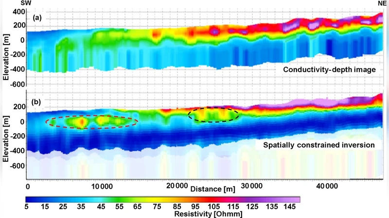
Reprocessing of regional-scale airborne electromagnetic data (AEM) is used to build a 3D geomodel of the Nasia sub-basin. The resulting 3D geomodel integrates all the prior pieces of information brought by electromagnetic data, lithologic logs, and prior geological knowledge. The AEM data, consisting of GEOTEM B-field data, were originally collected for mineral exploration. Thus, those B-field data had to be (re)processed and properly inverted as the original survey and data handling were designed for the detection of potential mineral targets and not for detailed geological mapping. These new inversions provided a different picture of the subsurface. The new geophysical model led to new interpretations of the geological settings and to the construction of a comprehensive 3D geomodel of the basin. The evidence of a system of paleovalleys could be inferred from the AEM data. The stratigraphy of these paleovalleys suggests a different glaciation history from the known Marinoan events, commonly associated with the Kodjari formation of the Voltaian sedimentary basin. The presence of the paleovalleys within the Panabako may be correlated with mountain glaciation within the Sturtian age, though no unequivocal glaciogenic strata have yet been identified. Pre-Marinoan glaciation is recorded in rocks of the Wassangara group of the Taoudeni Basin. The combination of the Marinoan and, possibly, Sturtian glaciation episodes, both of the Cryogenian period, can be an indication of a Neoproterozoic Snowball Earth. The occurrence of those features not only has important socioeconomic consequences - as the paleovalleys can act as reservoirs for groundwater - but also from a scientific point of view, they could require a revision of the present stratigraphy of the area.
💡 Research Summary
This paper presents a comprehensive re‑evaluation of the Nasia sub‑basin in northern Ghana by repurposing airborne electromagnetic (AEM) data originally collected for mineral exploration. The authors re‑process the GEOTEM B‑field dataset, which was designed for detecting mineralized targets, using modern noise‑reduction, time‑frequency filtering, and three‑dimensional inversion techniques. The resulting high‑resolution conductivity model (≈30 m spatial resolution) captures subtle variations in the shallow subsurface (10–200 m depth) that were previously obscured.
The newly derived conductivity volumes are integrated with existing borehole logs (resistivity, gamma‑ray, neutron), surface geological maps, and structural interpretations to build a unified 3‑D geological model of the basin. Key observations include elongated zones of elevated conductivity that form linear, valley‑like features ranging from 1 to 3 km in length and 200–500 m in width. These features correspond to high‑conductivity sand‑stone and conglomerate bodies bounded by low‑conductivity shales and mudstones, suggesting the presence of ancient fluvial or glacially carved paleovalleys that have been infilled with coarse‑grained, well‑sorted sediments.
Stratigraphically, the paleovalleys intersect the Panabako formation, a unit previously interpreted as solely post‑Marinoan. Their geometry and inferred depositional environment point to an older glacial episode, likely the Sturtian glaciation (≈720–635 Ma), rather than the Marinoan event (≈650–635 Ma) that is traditionally linked to the Kodjari formation of the Voltaian basin. This interpretation aligns with pre‑Marinoan glacial records in the Wassangara Group of the neighboring Taoudeni Basin, indicating that the region experienced at least two major Cryogenian glaciations. The coexistence of Marinoan and Sturtian signatures supports a “Snowball Earth” scenario for this part of West Africa.
Beyond its scientific implications, the study highlights significant socioeconomic relevance. The identified paleovalleys exhibit high porosity and permeability (estimated hydraulic conductivity ≈10⁻⁴ m s⁻¹) and are therefore promising groundwater reservoirs. Numerical groundwater flow simulations suggest that each valley could store on the order of 0.5 km³ of water, offering a potential solution to water scarcity in the region and providing a target for future water‑resource development.
The paper underscores the value of re‑using legacy AEM datasets: with appropriate re‑processing, data collected for one purpose (mineral exploration) can be transformed into a powerful tool for detailed geological mapping, stratigraphic revision, and hydrogeological assessment. The authors conclude that the new 3‑D geomodel not only refines the stratigraphic framework of the Nasia sub‑basin but also calls for an update of regional geological textbooks and exploration models to incorporate the newly recognized Sturtian‑age paleovalleys and their implications for Neoproterozoic glaciation history.