Geospatial Big Data Handling Theory and Methods: A Review and Research Challenges
Big data has now become a strong focus of global interest that is increasingly attracting the attention of academia, industry, government and other organizations. Big data can be situated in the disciplinary area of traditional geospatial data handling theory and methods. The increasing volume and varying format of collected geospatial big data presents challenges in storing, managing, processing, analyzing, visualizing and verifying the quality of data. This has implications for the quality of decisions made with big data. Consequently, this position paper of the International Society for Photogrammetry and Remote Sensing (ISPRS) Technical Commission II (TC II) revisits the existing geospatial data handling methods and theories to determine if they are still capable of handling emerging geospatial big data. Further, the paper synthesises problems, major issues and challenges with current developments as well as recommending what needs to be developed further in the near future. Keywords: Big data, Geospatial, Data handling, Analytics, Spatial Modeling, Review
💡 Research Summary
**
The paper provides a comprehensive review of the current state of geospatial big‑data handling theory and methods, focusing on whether traditional geospatial data management approaches can meet the demands imposed by the rapid growth in volume, variety, velocity, and veracity of spatial information. It begins by contextualising big data within the geospatial domain, outlining the four V’s and illustrating how they manifest in satellite imagery, LiDAR point clouds, sensor networks, and crowdsourced location data. The authors then critically assess legacy GIS architectures—layered models, relational database management systems, and classic spatial indexing structures such as R‑trees and Quad‑trees—highlighting their limitations in scaling to terabyte‑scale, real‑time streams. Memory and I/O bottlenecks, lack of schema flexibility, and insufficient support for continuous spatial‑temporal queries are identified as primary obstacles.
Subsequently, the paper surveys modern distributed storage solutions. Hadoop Distributed File System (HDFS) offers horizontal scalability but requires auxiliary spatial indexing layers to preserve query performance. NoSQL platforms (Cassandra, MongoDB, HBase) provide schema‑agnostic writes and high throughput, yet they fall short on spatial join efficiency and ACID guarantees. The authors discuss emerging geo‑big‑data frameworks such as GeoMesa, GeoSpark, and Apache Sedona, which integrate spatial indexing with columnar formats (Parquet, ORC) and enable efficient processing of heterogeneous geospatial objects.
In the analytics section, the authors detail how MapReduce and Spark have been adapted for large‑scale spatial operations, including buffering, overlay, clustering, and kernel density estimation. They describe Spark’s RDD/DataFrame APIs, partitioning strategies, and the use of GPU/FPGA accelerators for raster processing, demonstrating order‑of‑magnitude speedups over traditional desktop GIS tools. The discussion emphasizes the importance of algorithmic redesign to exploit data locality and parallelism inherent in distributed environments.
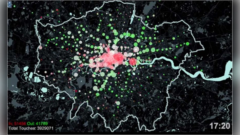
Visualization challenges are examined next. Web‑based 3D mapping libraries (WebGL, CesiumJS, Deck.gl) combined with multi‑scale tiling and level‑of‑detail (LOD) techniques enable interactive exploration of massive datasets, but issues such as client‑side memory limits, latency, and privacy‑preserving rendering remain unresolved. The paper stresses the need for standards that balance performance with the protection of sensitive location information.
Quality assurance is addressed through a review of metadata standards (ISO 19115, OGC SensorML) and automated error‑detection methods, ranging from statistical outlier detection to machine‑learning classification of corrupted records. The authors propose a set of quantitative metrics for assessing spatial data veracity—accuracy, consistency, timeliness, and trustworthiness—and argue that systematic quality control is essential for reliable decision‑making.
Finally, the authors conclude that existing geospatial theories and methods are insufficient to fully accommodate the 3V+V (volume, variety, velocity, veracity) paradigm of big data. They outline four research directions: (1) development of novel spatial‑temporal data structures (e.g., streaming spatial indexes, time‑aware graph models); (2) integration of privacy‑preserving techniques such as differential privacy and homomorphic encryption for secure data sharing; (3) creation of AI‑driven pipelines for automatic data cleaning, integration, and semantic enrichment; and (4) establishment of cloud‑native GIS platforms with standardized APIs to foster interoperability and scalability. By pursuing these avenues, the geospatial community can transform big data from a technical challenge into a robust foundation for informed policy, environmental monitoring, and societal benefit.
Comments & Academic Discussion
Loading comments...
Leave a Comment