Distribution of interseismic coupling along the North and East Anatolian Faults inferred from InSAR and GPS data
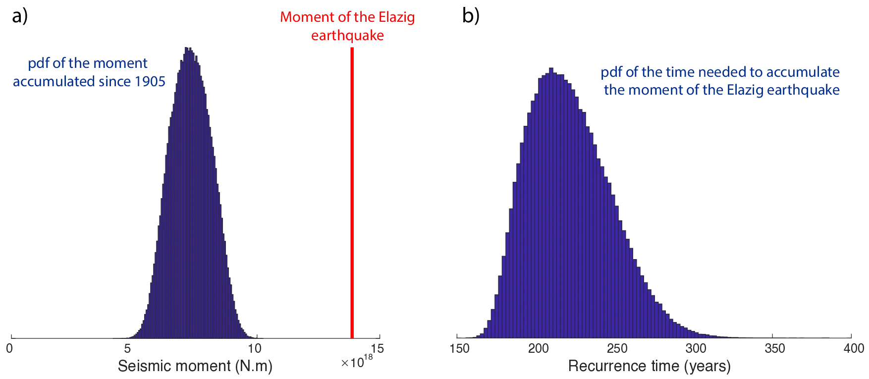
The North Anatolian Fault (NAF) has produced numerous major earthquakes. After decades of quiescence, the $\rm{M_w}$ 6.8 Elazığ earthquake (January 24, 2020) has recently reminded us that the East Anatolian Fault (EAF) is also capable of producing significant earthquakes. To better estimate the seismic hazard associated with these two faults, we jointly invert Interferometric Synthetic Aperture Radar (InSAR) and GPS data to image the spatial distribution of interseismic coupling along the eastern part of both the North and East Anatolian Faults. We perform the inversion in a Bayesian framework, enabling to estimate uncertainties on both long-term relative plate motion and coupling. We find that coupling is high and deep (0-20 km) on the NAF and heterogeneous and superficial (0-5 km) on the EAF. Our model predicts that the Elazığ earthquake released between 200 and 250 years of accumulated moment, suggesting a bi-centennial recurrence time.
💡 Research Summary
This study investigates the spatial distribution of interseismic coupling along the eastern segments of the North Anatolian Fault (NAF) and the East Anatolian Fault (EAF) using a joint inversion of Interferometric Synthetic Aperture Radar (InSAR) and Global Positioning System (GPS) observations within a Bayesian framework. The authors compiled three Envisat InSAR tracks (two descending, one ascending) covering 2003‑2010 and horizontal velocity data from 72 GPS stations, yielding 144 GPS components and a down‑sampled set of InSAR pixels. The fault system was discretized into 110 depth‑dependent sub‑faults, and the inversion simultaneously solved for back‑slip on each sub‑fault and for the rotation vectors of the Anatolian and Arabian plates. Plate rotations were not imposed a priori; instead, Euler‑pole parameters from Le Pichon & Kreemer (2010) were used as Gaussian priors, allowing the data to refine them. Uniform priors were assigned to back‑slip values between zero and the long‑term slip rates (19.5 mm yr⁻¹ for NAF, 13 mm yr⁻¹ for EAF). Using the AlTar1 MCMC sampler, 100 000 model realizations were generated, providing posterior probability density functions for all parameters.
The posterior rotation vectors closely match, but are not identical to, the published global plate motions, indicating slight regional deviations likely due to non‑rigid plate behavior. The inferred long‑term slip rates are ~20 mm yr⁻¹ on the NAF and ~10 mm yr⁻¹ on the EAF, consistent with previous studies. Coupling coefficients were obtained by normalizing back‑slip by the local long‑term slip rate. Results show that the NAF is strongly coupled (≈80 % or higher) from the surface down to 20 km depth across the studied segment. In contrast, the EAF exhibits heterogeneous, shallow coupling confined to the upper 0‑5 km, with values typically between 30 % and 60 % and a rapid decrease with depth. Uncertainty is higher (>25 %) at the western and eastern ends of the profile where data coverage is sparse.
By overlaying the coupling maps with the rupture geometry of the Mw 6.8 Elazığ earthquake (January 24 2020), the authors find that the event nucleated in a narrow (≈5 × 14 km) shallow, strongly coupled patch on the EAF and then propagated into regions of lower coupling. The seismic moment released corresponds to the accumulation of 221 ± 26 years of slip deficit, implying a bi‑centennial recurrence interval (≈200‑250 years) for similar events on this segment. Similar shallow, high‑coupling patches are identified elsewhere along the EAF, suggesting that other segments could also host comparable earthquakes given sufficient time.
Key contributions of the paper include: (1) simultaneous Bayesian estimation of plate rotations and fault coupling, providing rigorous uncertainty quantification; (2) high‑resolution coupling maps that reveal marked differences between the NAF (deep, uniform coupling) and the EAF (shallow, heterogeneous coupling); (3) a refined estimate of the Elazığ earthquake’s slip deficit and recurrence time; and (4) evidence that regional plate rotation parameters differ subtly from global models, underscoring the need for locally constrained kinematics in seismic hazard assessments.
Overall, the study demonstrates that a Bayesian joint inversion of InSAR and GPS data can robustly characterize interseismic coupling and plate motions, offering valuable inputs for probabilistic seismic hazard models and for understanding the rupture potential of complex fault systems such as the NAF‑EAF network.
Comments & Academic Discussion
Loading comments...
Leave a Comment