Cooperative Passive Coherent Location: A Promising 5G Service to Support Road Safety
5G promises many new vertical service areas beyond simple communication and data transfer. We propose CPCL (cooperative passive coherent location), a distributed MIMO radar service, which can be offered by mobile radio network operators as a service for public user groups. CPCL comes as an inherent part of the radio network and takes advantage of the most important key features proposed for 5G. It extends the well-known idea of passive radar (also known as passive coherent location, PCL) by introducing cooperative principles. These range from cooperative, synchronous radio signaling, and MAC up to radar data fusion on sensor and scenario levels. By using software-defined radio and network paradigms, as well as real-time mobile edge computing facilities intended for 5G, CPCL promises to become a ubiquitous radar service which may be adaptive, reconfigurable, and perhaps cognitive. As CPCL makes double use of radio resources (both in terms of frequency bands and hardware), it can be considered a green technology. Although we introduce the CPCL idea from the viewpoint of vehicle-to-vehicle/infrastructure (V2X) communication, it can definitely also be applied to many other applications in industry, transport, logistics, and for safety and security applications.
💡 Research Summary
The paper introduces Cooperative Passive Coherent Location (CPCL), a novel radar‑as‑a‑service concept that turns the future 5G mobile network into a distributed MIMO radar system. Building on the well‑known principle of passive coherent location (PCL), which exploits “transmitters‑of‑opportunity” such as broadcast or cellular base stations, CPCL adds full network‑level cooperation. All radio nodes—base stations, roadside units (RSUs), and vehicle user equipment (UE)—can act as illuminators or observers, and the network’s synchronization, medium‑access control, and resource‑allocation mechanisms guarantee orthogonal, interference‑free operation.
Key enabling technologies of 5G are leveraged: OFDMA (and its filter‑bank variants) provides a wideband, orthogonal waveform; massive MIMO and beamforming enable spatial filtering; carrier aggregation and channel bonding increase bandwidth for high range resolution; and low‑latency mobile edge computing (MEC) supplies the processing power for real‑time data fusion and radar‑parameter control. The authors detail the signal‑processing chain: after standard OFDM reception (synchronization, CP removal, FFT, channel estimation, equalization), the recovered transmitted symbols are used to invert the channel, yielding a channel impulse response (fast‑time). A second FFT across successive OFDM symbols produces the Doppler (slow‑time) dimension, resulting in a two‑dimensional delay‑Doppler spreading function. Target detection is performed on the magnitude‑squared scattering function, with integration time chosen to balance SNR gain against target motion‑induced smearing.
In multi‑user LTE‑Advanced/5G resource grids, physical resource blocks (PRBs) are sparsely allocated across users, creating a non‑uniform sampling pattern that distorts the classic sinc‑squared ambiguity function. CPCL can mitigate this by reserving radar‑specific PRBs, employing sparse‑reconstruction techniques, or adapting the waveform to the allocated grid. Because the communication signal carries unknown data symbols, the cooperative environment allows the network to recover the transmitted waveform (no separate reference channel is needed), simplifying hardware.
The paper positions CPCL as a “green radar”: the same spectrum and RF front‑ends serve both communication and sensing, eliminating the need for dedicated radar bands and reducing capital expenditure. As 5G infrastructure expands, coverage and performance of the radar service automatically improve. MEC aggregates delay‑Doppler measurements from many nodes, fuses them with map data and other sensors (e.g., automotive ACC radars), and delivers high‑confidence situational awareness for intelligent transport systems (ITS).
Challenges identified include: (1) achieving high dynamic range and rapid channel estimation for fast‑moving targets; (2) designing MAC and scheduling policies that guarantee sufficient radar‑specific resources without harming communication QoS; (3) handling multipath and clutter in dense urban environments, possibly via advanced beamforming and machine‑learning‑based clutter suppression; (4) addressing privacy and security of sensed data; and (5) validating the concept at scale and integrating it into standards.
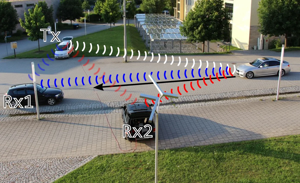
A preliminary measurement campaign demonstrates feasibility: OFDM symbols transmitted by a vehicle and an RSU were processed to extract delay‑Doppler maps, revealing moving targets with range resolution comparable to dedicated automotive radars.
In conclusion, CPCL transforms the 5G cellular network into a ubiquitous, adaptive radar platform. By reusing existing spectrum and hardware, it offers a cost‑effective, high‑resolution sensing service that can support cooperative driving, traffic‑management, logistics, and broader public‑safety applications, opening a new vertical for 5G beyond traditional broadband communication.
Comments & Academic Discussion
Loading comments...
Leave a Comment