Spatially Continuous and High-resolution Land Surface Temperature: A Review of Reconstruction and Spatiotemporal Fusion Techniques
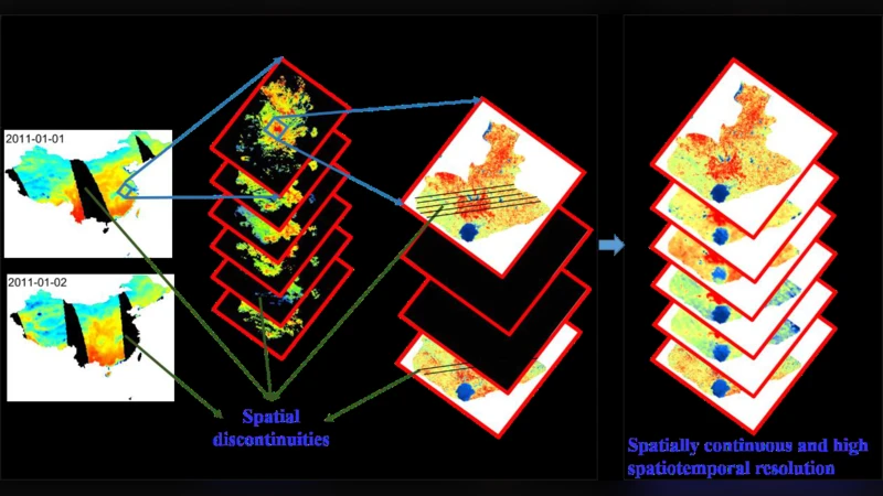
Remotely sensed, spatially continuous and high spatiotemporal resolution (hereafter referred to as high resolution) land surface temperature (LST) is a key parameter for studying the thermal environment and has important applications in many fields. However, difficult atmospheric conditions, sensor malfunctioning and scanning gaps between orbits frequently introduce spatial discontinuities into satellite-retri1eved LST products. For a single sensor, there is also a trade-off between temporal and spatial resolution and, therefore, it is impossible to obtain high temporal and spatial resolution simultaneously. In recent years the reconstruction and spatiotemporal fusion of LST products have become active research topics that aim at overcoming this limitation. They are two of most investigated approaches in thermal remote sensing and attract increasing attention, which has resulted in a number of different algorithms. However, to the best of our knowledge, currently no review exists that expatiates and summarizes the available LST reconstruction and spatiotemporal fusion methods and algorithms. This paper introduces the principles and theories behind LST reconstruction and spatiotemporal fusion and provides an overview of the published research and algorithms. We summarized three kinds of reconstruction methods for missing pixels (spatial, temporal and spatiotemporal methods), two kinds of reconstruction methods for cloudy pixels (Satellite Passive Microwave (PMW)-based and Surface Energy Balance (SEB)-based methods) and three kinds of spatiotemporal fusion methods (weighted function-based, unmixing-based and hybrid methods). The review concludes by summarizing validation methods and by identifying some promising future research directions for generating spatially continuous and high resolution LST products.
💡 Research Summary
The paper provides a comprehensive review of the state‑of‑the‑art methods for generating spatially continuous, high‑resolution land surface temperature (LST) products by addressing two fundamental challenges: (1) missing or corrupted pixels caused by atmospheric conditions, sensor failures, and orbital scanning gaps, and (2) the inherent trade‑off between spatial and temporal resolution in any single satellite sensor. The authors first categorize reconstruction techniques for missing pixels into three families: spatial‑only, temporal‑only, and spatiotemporal approaches. Spatial methods exploit the autocorrelation of neighboring pixels using classic interpolation, Kriging, spline, or machine‑learning regressors. Temporal methods rely on historical observations at the same location, applying linear interpolation, Kalman filtering, or advanced time‑series models such as ARIMA and recurrent neural networks. Spatiotemporal methods combine both dimensions, employing weighted averages, multivariate regression, or deep‑learning architectures (U‑Net, ConvLSTM) that jointly model space and time.
For cloudy pixels, two principal strategies are reviewed. The first uses satellite passive microwave (PMW) observations, which can penetrate clouds but suffer from coarse spatial resolution; therefore, PMW‑derived temperatures must be downscaled and merged with higher‑resolution optical LST. The second strategy is based on surface energy balance (SEB) models that compute radiative, sensible, and latent heat fluxes to infer the temperature beneath clouds. SEB approaches require ancillary meteorological and land‑surface parameters but are sensor‑agnostic and can be applied across diverse climatic regimes.
The second major part of the review focuses on spatiotemporal fusion techniques that aim to synthesize high‑spatial‑low‑temporal (e.g., Landsat, Sentinel‑2) and low‑spatial‑high‑temporal (e.g., MODIS, VIIRS) LST datasets. Fusion methods are grouped into three categories: weighted‑function based, unmixing‑based, and hybrid methods. Weighted‑function approaches assign temporal and spatial weights to the two data streams; classic examples include STARFM, ESTARFM, and their extensions. Unmixing‑based methods decompose coarse‑resolution pixels into sub‑pixel fractions (soil, vegetation, water) and propagate the temporal dynamics of each fraction to reconstruct a fine‑resolution time series; algorithms such as UNMIX and ESTARFM‑UNMIX belong to this class. Hybrid methods combine the strengths of the previous two or incorporate deep learning to learn optimal weights, extract hierarchical features, and enforce spatiotemporal consistency. Recent advances feature ConvLSTM, generative adversarial networks (GANs), and Transformer models that have shown promising results in generating high‑resolution LST while preserving physical realism.
Validation practices are also surveyed. Ground‑based measurements, airborne campaigns, and high‑resolution reference satellite products are used for accuracy assessment. Standard statistical metrics (RMSE, MAE, R²) are complemented by spatial diagnostics (semivariograms, Moran’s I) to evaluate pattern fidelity. The authors note persistent challenges: limited in‑situ data, seasonal and regional biases, and the difficulty of propagating uncertainty through complex fusion pipelines.
In concluding remarks, the paper outlines four promising research directions. First, rigorous quantification and propagation of uncertainty throughout reconstruction and fusion workflows. Second, the development of a unified multi‑sensor, multi‑scale framework capable of delivering globally consistent, high‑resolution LST products. Third, enhancing interpretability of deep‑learning models and integrating them with physically based SEB or radiative transfer models to create hybrid physics‑machine learning systems. Fourth, operationalizing these methods in real‑time processing chains using cloud computing and scalable data‑pipeline architectures. The authors argue that progress along these lines will substantially improve the utility of LST for urban heat‑island monitoring, agricultural drought assessment, climate change studies, and a broad spectrum of environmental applications.
Comments & Academic Discussion
Loading comments...
Leave a Comment