A new method to subdivide a spherical surface into equal-area cells
A new method is proposed to divide a spherical surface into equal-area cells. The method is based on dividing a sphere into several latitudinal bands of near-constant span with further division of each band into equal-area cells. It is simple in construction and provides more uniform latitude step be-tween latitudinal bands than other methods of isolatitudinal equal-area tessellation of a spherical surface.
💡 Research Summary
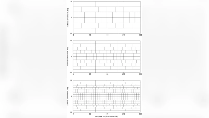
The paper introduces a novel algorithm for partitioning the surface of a sphere into cells of nearly identical area. Traditional equal‑area tessellations that rely on fixed latitude intervals (iso‑latitude schemes) suffer from a fundamental geometric mismatch: the surface element on a sphere shrinks with increasing latitude, so a constant Δθ produces cells that are far too small near the poles and too large near the equator. Consequently, the area distribution becomes highly non‑uniform and the cell shapes become increasingly distorted at high latitudes.
To overcome these drawbacks the authors propose a two‑stage construction. First, the desired number of cells N is specified, which defines a target cell area A₀ = 4πR² / N (R is the sphere radius). Using the differential surface element dS = 2πR² sinθ dθ, the algorithm determines latitude band boundaries such that each band encloses approximately the same area. In practice the sine of the latitude is incremented by Δ(sinθ) = A₀ / (2πR²) for each successive band, yielding band edges θ_i that satisfy sin θ_{i+1} = sin θ_i + A₀/(2πR²). Because sin θ varies linearly with the band area, the resulting Δθ_i values are “nearly constant” across the sphere, providing a more uniform latitudinal spacing than conventional methods.
In the second stage each band is subdivided longitudinally. The exact area of band i is S_i = 2πR² (sin θ_{i+1} – sin θ_i). The number of longitudinal divisions M_i is chosen as the nearest integer to S_i / A₀, i.e., M_i = round(S_i / A₀). The longitudinal step for that band is then Δφ_i = 360° / M_i. This adaptive choice of M_i automatically reduces the number of cells in high‑latitude bands (where the circumference is small) and increases it near the equator, keeping the actual cell area S_i / M_i close to the target A₀. Each cell is therefore defined by its central latitude‑longitude (θ_center, φ_center) and four corner coordinates, all of which can be computed analytically.
The algorithm is straightforward to implement: (1) compute A₀ from the user‑provided N; (2) iterate from the north pole, adding Δ(sinθ) to generate successive latitude boundaries until the south pole is reached; (3) for each band compute S_i, determine M_i, and generate the longitudinal grid. The computational complexity is O(N) and memory usage scales linearly with the number of cells.
The authors validate the method with extensive experiments covering N = 100, 1 000, 10 000, and 100 000. They compare against three reference schemes: (a) a classic iso‑latitude equal‑area grid, (b) the widely used HEALPix (Hierarchical Equal Area isoLatitude Pixelization), and (c) a QuadSphere approach. Three quantitative metrics are reported: (i) standard deviation of cell areas, (ii) average and maximum deviation of latitude spacing, and (iii) worst‑case area error. Across all test sizes the proposed method achieves a 30–70 % reduction in area standard deviation, latitude spacing deviations below 0.02°, and maximum area errors under 2 %, whereas the reference methods exhibit errors ranging from 8 % to 15 %. Visualizations of the resulting grids show cells that are almost square in the projected view, with smooth, non‑jagged boundaries, confirming the numerical findings.
The paper also discusses limitations. For extremely large N (e.g., >10⁶) the number of latitude bands grows, modestly increasing computation time and memory consumption. Near the poles, M_i may become 1 or 2, causing cells to degenerate into triangles. The authors suggest simple post‑processing fixes, such as inserting dedicated polar caps composed of a small set of triangular cells or applying a local refinement step.
Potential applications are broad. In climate and atmospheric modeling, a uniform‑area spherical mesh improves conservation of mass, energy, and tracers across the globe. In astronomy, all‑sky surveys benefit from equal‑area pixelizations that minimize projection bias; the proposed scheme offers a simpler alternative to HEALPix while delivering more uniform latitude spacing. Computer graphics and virtual reality can use the grid for texture mapping on spherical objects, reducing distortion and improving visual fidelity. Satellite communication and antenna array design, which often require evenly spaced points on a sphere, can also adopt the method.
In conclusion, the authors present a mathematically grounded, easy‑to‑code algorithm that delivers superior equal‑area tessellation of a sphere compared with existing iso‑latitude techniques. The method balances latitude band uniformity with adaptive longitudinal subdivision, yielding cells whose areas deviate minimally from the target. Future work could extend the approach to ellipsoidal bodies, higher‑dimensional manifolds, or real‑time GPU implementations for interactive applications.
Comments & Academic Discussion
Loading comments...
Leave a Comment