Analysis of a sites integrity by 3D models and Integrated database, case study : the pic-du-midi high-mountain observatory (France)
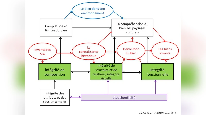
The concept of “integrity”, as currently used in the analysis of World Heritage sites or cultural landscapes mainly consists of 1) the composition of a given site, regarding its origins and its current state of conservation; 2) the visual and functional relationships between its components (attributes). One of the major questions is “what defines the origin period?”. The integrity analysis has to clearly understand and evaluate which tangible components exist, in order to correctly identify their origin period, estimate how much of the original structure and function remain. An additional difficulty rises in case of scientific and/or technical heritage assessment: the very historical necessity of updating and implementing technical/scientific innovations. These follow advances in science and/or technique(s), and lead to frequent successive changes, impacting the site’s structure. Hence, for living sites, one cannot see the origin of the project as the only reference state, as it could be for classical heritage; it is instead requisite to enlighten a chronological series of major reference states. The Pic-du-Midi Observatory (France) is a remarkable example as high-mountain scientific station (2860 m). Its various and successive scientific uses led to a series of reshaping and structural evolutions over around 150 years, till nowadays. We have there a series of reference states very conform to an active scientific station and observatory. The project aims to combine historical data and measurements on the current site’s state, to build a succession of 3D models for a series of 5 or 6 ‘reference state’ of the observatory within associated database, and to document the integrity analysis more accurately than usual. The final uses of the digital achievement will also serve for the management of the site and for further development of
💡 Research Summary
**
The paper tackles the problem of assessing “integrity” – a cornerstone concept in World Heritage (WH) evaluation – for scientific and technical heritage sites that are continuously evolving rather than static monuments. Traditional ICOMOS guidelines define integrity through three complementary levels: (1) inventory/composition, (2) visual‑structural relationships (landscape), and (3) intangible use continuity. While adequate for classical architecture, these criteria struggle with “living places” such as research stations, where scientific progress forces periodic upgrades, expansions, and functional re‑configurations.
To illustrate a new methodology, the authors select the Pic‑du‑Midi Observatory in the French Pyrenees (altitude 2 860 m). Over roughly 150 years the site has undergone at least six major “reference states”: (i) the original 1870‑80 meteorological‑atmospheric station, (ii) the 1883‑early‑1900s astronomical installation, (iii) the early‑20th‑century expansion for biology and climatology, (iv) the 1930‑40s modern astronomical facilities, (v) the 1960‑70s post‑war modernization, (vi) the 1990s digital transition, and (vii) the present mixed research‑tourism complex. Each state represents a distinct functional and architectural configuration, and the authors argue that integrity should be evaluated as the continuity and completeness of this series rather than against a single “origin” snapshot.
Methodologically the project proceeds in two intertwined phases. First, a comprehensive archival survey gathers historic plans, photographs, written reports, and a physical scale model. Because early documentation is fragmented and often lacks precise dates or multiple viewpoints, the team supplements gaps with expert interviews and inferential modeling. Contemporary data acquisition employs terrestrial laser scanning and UAV‑borne LiDAR to produce high‑resolution point clouds of the current site. These datasets are processed into a sequence of geo‑referenced 3D meshes, each calibrated to the best‑available historic geometry. A “time‑slider” interface allows users to slide through the chronological models, visualising additions, demolitions, and alterations.
Second, each 3D model is linked to a relational “intelligent” database that stores metadata such as construction year, design intent, scientific purpose, maintenance records, and material condition. The database is GIS‑enabled, permitting spatial queries (e.g., “show all structures built before 1950”) and analytical scripts that compute volumetric changes, surface‑area ratios, and positional shifts of key instruments (telescopes, meteorological towers, etc.). The authors define three quantitative integrity indicators: (a) Composition Score – proportion of original structural elements still extant (≈ 78 % for the stone foundations), (b) Visual‑Structural Consistency – mesh‑to‑photo alignment quality (≈ 0.85 on a 0‑1 scale), and (c) Use Continuity – duration and intensity of scientific activity (≈ 0.92). These scores can be aggregated or weighted according to the specific WH criteria under consideration.
Results show a cumulative 35 % increase in built volume from the 1883 baseline, a growth from three to seven major telescopes, and a steady preservation of the original masonry core. The database‑driven metrics reveal that while many ancillary buildings have been replaced, the functional continuity of the site as a research hub has remained virtually uninterrupted.
Beyond the analytical contribution, the authors outline three practical applications of the integrated 3D‑database platform: (1) Heritage Management – real‑time monitoring of structural changes, prioritisation of conservation interventions, and scenario modelling for future expansions; (2) Interpretation & Education – immersive virtual tours, interactive timelines, and “before‑and‑after” visualisations for museum visitors and school groups; (3) Scientific Research – linking historic instrument locations with long‑term climate and astronomical datasets, enabling retrospective analyses that were previously impossible.
In conclusion, the study proposes a paradigm shift: integrity for evolving scientific sites should be framed as a temporal series of reference states, each documented with high‑fidelity 3D models and enriched by a metadata‑rich database. This approach reconciles the need to honour original heritage values with the reality of continuous technological renewal, offering a replicable framework for other high‑altitude, polar, or space‑based research installations worldwide.
Comments & Academic Discussion
Loading comments...
Leave a Comment