An Early Development of Flood Inundation Mapping Method Using Free Android Application to Support Emergency Response Activities: Case Study Baleendah, Bandung, West Java
This study aims to simplify the current flood mapping methodology, so it can be done in quicker time, easy to learn, but still produce accurate flood information to support the emergency responses. This study is divided into two activities: Survey development and flood mapping methods; Field survey and mapping to test the developed method. The method development was then conducted by examining the simple methods in the flood mapping survey and then testing it in the field. The results of these trials were then evaluated to determine the most effective and efficient methods. The utilization of free android mapping application to conduct flood survey shows satisfactory results. Based on two trials, it was known that it takes only 4 hours to conduct a 15 km survey of Citarum River segment. The mapping shows that the flood areas in Baleendah and its surrounding reached 763 Ha and 794 Ha respectively on 25 December 2014 and 13 March 2016. In addition, the method developed is also relatively easy to use, so it is expected to trigger the local communities to play an active role in disaster prevention efforts, especially in emergency response by providing accurate information about the flood inundation areas.
💡 Research Summary
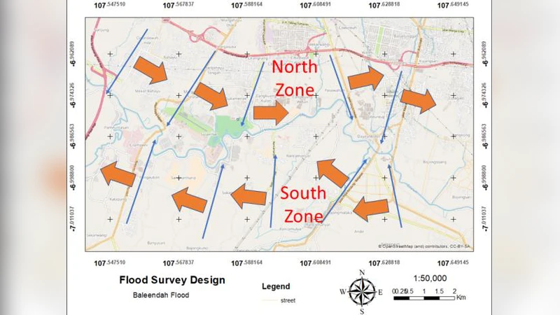
This study presents a streamlined flood inundation mapping methodology that leverages a free Android mapping application, Orux Map, to produce rapid, accurate flood extent information suitable for emergency response. Conducted in the Baleendah sub‑district of Bandung, West Java, the research is divided into method development and field validation phases. During method development, the authors designed a simple field survey protocol: the study area along the Citarum River was split into northern and southern zones, each further divided into five entry points based on road accessibility. A team of 13 volunteers, organized into six groups, used motorcycles and Android smartphones to travel alleys, record GPS coordinates of the flood reach, and capture photographs of the water line.
Two full‑scale flood events were surveyed: 25 December 2014 and 13 March 2016. In the first event, 100 coordinate points were collected, yielding an inundated area of 763.48 ha; the Dayeuhkolot village accounted for 93.15 % of the total flooded surface, while Andir village exhibited the widest local inundation (211.16 ha). In the second event, 69 points produced an inundated area of 794.1 ha. Both events displayed similar spatial patterns, confirming the repeatability of the approach.
Post‑processing involved digitizing the field‑collected points, integrating them with a digital elevation model (DEM) and Terrasar topographic data, and interpolating flood boundaries in a GIS environment. The resulting maps were cross‑validated against Google Earth satellite imagery; the 2016 survey coincided with a satellite overpass, allowing a direct visual comparison that demonstrated strong agreement in residential zones. However, the method under‑represented inundation in rice‑field areas because the motorcycle‑based team could not access those fields, highlighting a limitation related to mobility.
Efficiency metrics showed an average survey speed of 6.2 km h⁻¹, with a 15 km river segment surveyed in under four hours. This speed, combined with the low cost of a single motorcycle, a smartphone, and minimal data usage, makes the approach markedly cheaper than vehicle‑based surveys while maintaining sub‑100 m positional accuracy. Real‑time plotting on Google Earth during fieldwork further accelerated decision‑making, enabling rapid dissemination of flood extents to local authorities and residents, thereby supporting timely evacuations.
The authors conclude that the free Android‑based Orux Map system provides a viable, community‑friendly tool for rapid flood mapping. Its simplicity encourages participation from local residents, fostering a bottom‑up disaster‑risk management culture. To address the identified shortcomings, future work should explore complementary data collection methods such as drone photogrammetry, foot‑based surveys, or automated point extraction algorithms, and integrate the rapid mapping workflow into broader flood‑risk monitoring frameworks. Overall, the study demonstrates that low‑cost, open‑source technologies can substantially enhance emergency response capabilities in resource‑constrained settings.
Comments & Academic Discussion
Loading comments...
Leave a Comment