Mapping groundwater potential zones in Cilongok Area, Banyumas, Central Java using 2D geoelectrical resistivity
The aim of this study is to investigate the presence of potential aquifer layers that would be used as a source of clean water for residents in Cilongok sub-district. We conducted a ground water potential survey at two locations in the sub-district, i.e. Cikidang and Kalisari villages. At each location, geoelectric measurements were taken with the Wenner configuration and the horizontal distance of 900 meters, so that we can get the estimation of lithology layers that potentially store groundwater up to the depth of $\pm 100$ meters. Then the measurement result was processed by using Res2DInv software to get the 2D resistivity images of rock layers. Based on the resistivity estimation and observation of regional geological conditions in that area, then we conducted 2D interpretation about potential lithology layers that economically potential for water well drilling and to be utilized as a source of clean water for the residents. Based on the interpretation of lithology, it was known that the aquifer layer that has the potential as a source of clean water is a layer that consists of coarse and porous tuffs from volcanic eruption products that can easily drain groundwater on the average about 28 to 45 meters depth in Cikidang village and about 45 to 60 meters depth in Kalisari village.
💡 Research Summary
The paper investigates groundwater potential in the Cilongok sub‑district of Banyumas Regency, Central Java, focusing on two villages—Cikidang and Kalisari—where clean water shortages have been reported. The authors note that rapid land clearing, industrial activities, and volcanic influences have degraded existing water resources, prompting a need for systematic subsurface exploration.
Geologically, both villages lie within the North Serayu mountainous zone, underlain by Holocene volcanic deposits from Mount Slamet, primarily andesite‑basaltic lahar and volcanic breccia. These materials are typically porous and permeable, suggesting the presence of locally productive aquifers that store water in fissures and inter‑grain spaces.
To delineate these aquifers, the study employed a 2‑D electrical resistivity survey using the Wenner array. Twelve survey lines were laid out—six in each village—with electrode spacing of 200 m and a total profile length of 900 m, allowing investigation to depths of roughly ±100 m. Field equipment included a Nainura NRD‑300 resistivity meter, a 1 kVA NLG EC1500AW generator, and GPS for precise positioning. Measured voltages and injected currents were converted to apparent resistivity values, which were then inverted using the Res2DInv software to produce 2‑D resistivity cross‑sections.
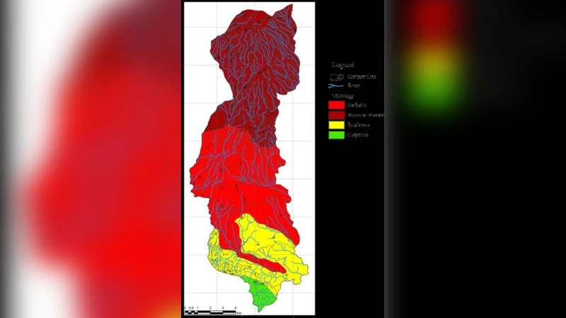
Interpretation relied on a reference table (Helide, 1984) that links typical resistivity ranges to lithologies and water content. Layers with resistivity <20 Ω·m were classified as alluvial (non‑aquifer) soils, 20‑60 Ω·m as coarse volcanic tuff (potential aquifer), and values >60 Ω·m as volcanic lava (assumed impermeable).
Results for Cikidang showed a shallow alluvial layer (0‑20 m) overlain by a coarse tuff zone extending roughly from 20 m to 60 m depth, with resistivity values between 20‑60 Ω·m. Below ~60 m, high‑resistivity lava deposits dominate. Across the six lines, the prospective aquifer depth varied between 16 m and 75 m, with an average optimal drilling depth of 28‑45 m.
In Kalisari, a similar pattern emerged: an alluvial cover (0‑30 m) followed by a coarse tuff interval from about 30 m to 70 m depth, again with 20‑60 Ω·m resistivity. Some lines indicated the tuff extending to 77 m. Beneath this, high‑resistivity lava layers were observed. The average depth for a viable aquifer in Kalisari was estimated at 45‑60 m.
The authors produced “fence diagrams” (2‑D lithological cross‑sections) for each village to visualize the spatial continuity of the identified aquifer units. They conclude that the coarse volcanic tuff layers represent the most promising targets for water‑well drilling, offering a feasible source of clean water for local residents.
However, the study has several limitations. The resistivity‑to‑lithology conversion does not incorporate site‑specific calibration (e.g., moisture content, temperature, electrode contact resistance), which can shift the apparent resistivity ranges. The inversion parameters (starting model, regularization, iteration count) are not detailed, leaving uncertainty about the robustness of the 2‑D images. No ground‑truthing (e.g., borehole logs, water‑quality sampling) was performed to validate that the 20‑60 Ω·m zones indeed contain fresh water. Moreover, the Wenner array provides limited lateral resolution; integrating other arrays (Schlumberger, dipole‑dipole) or 3‑D surveys could improve delineation of aquifer thickness and continuity.
In summary, the paper demonstrates that 2‑D electrical resistivity surveying can identify plausible groundwater‑bearing volcanic tuff layers in the Cilongok area, suggesting drilling depths of roughly 30‑45 m in Cikidang and 45‑60 m in Kalisari. While the methodology is sound for a preliminary assessment, further hydrogeological investigations—including drilling, pump‑test, and water‑quality analysis—are essential before the identified zones can be developed into reliable community water supplies.
Comments & Academic Discussion
Loading comments...
Leave a Comment