Finding Places: HCI Platform for Public Participation in Refugees Accommodation Process
This paper describes the conception, development and deployment of a novel HCI system for public participation and decision making. This system was applied for the process of allocating refugee accommodation in the City of Hamburg within the FindingPlaces project in 2016. The CityScope a rapid prototyping platform for urban planning and decision making offered a technical solution which was complemented by a workshop process to facilitate effective interaction of multiple participants and stakeholder groups. This paper presents the origins of CS and the evolution of the tangible user interface approach to urban planning and public participation. It further outlines technical features of the system, including custom hardware and software in use, utilization in real time as well as technical constraints and limitations. Special focus is on the adaptation of the CS technology to the specific demands of Hamburg FP project, whose procedures, processes, and results are reflected. The final section analyzes success factors as well as shortcomings of the approach, and indicates further R&D as well as application scenarios for the CS.
💡 Research Summary
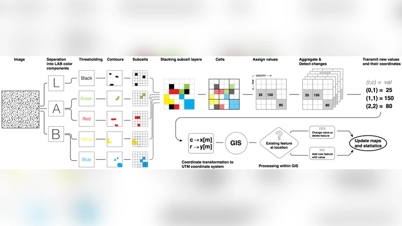
The paper presents the conception, development, and deployment of a novel Human‑Computer Interaction (HCI) platform—CityScope (CS)—used to involve Hamburg citizens in the allocation of refugee accommodation during the 2016 FindingPlaces (FP) project. Faced with a sudden influx of asylum seekers, the city needed a transparent, participatory process to avoid spatial concentration of shelters and associated public protests. CityScope, a tangible user interface (TUI) originally developed at MIT Media Lab, combines physical, color‑coded blocks with real‑time video tracking, GIS integration, and projection‑based visual feedback. For FP the authors redesigned both hardware (high‑resolution cameras, improved lighting) and software (image‑processing pipeline, GIS mapping, networked multi‑table communication) to support interactive tables that display a 1 : 750 scale view of Hamburg parcels enriched with ownership, land‑use, and capacity data. Participants place “accommodation‑capacity” bricks on parcels; the system instantly visualizes the impact on local density, compliance with zoning rules, and city‑wide statistics on auxiliary screens.
A workshop workflow was defined: data preprocessing, scenario design, in‑situ workshops, and result synthesis. Over three months, twelve workshops engaged roughly 350 citizens in small groups, each session lasting about two hours. Post‑session surveys and video coding showed that the TUI approach outperformed traditional pen‑and‑paper methods in fostering active discussion, rapid feedback, and shared understanding. Success factors identified include visual intuitiveness, real‑time feedback, multi‑scale map integration, and neutral facilitation. Limitations involve the finite number of physical blocks, sensitivity to lighting conditions, the need for technical staff, and the gap between citizen recommendations and formal policy adoption.
The authors propose future work to expand block types, enable remote participation via cloud‑based collaboration, and incorporate AI‑driven suitability analysis to further support decision‑making. Overall, the study demonstrates that a well‑engineered tangible interface can democratize complex urban planning tasks, increase transparency, and produce actionable insights for municipal authorities.
Comments & Academic Discussion
Loading comments...
Leave a Comment