Testing the ability of Multivariate Hybrid Spatial Network Analysis to predict the effect of a major urban redevelopment on pedestrian flows
Predicting how changes to the urban environment will affect town centre vitality, mediated as pedestrian flows, is important for environmental, social and economic sustainability. This study is a longitudinal investigation of before and after urban environmental change in a town centre and its association with vitality. The case study baseline is Cardiff town centre in 2007, prior and after major changes instigated by re-configuring Cardiff public and quasi-public street layout due to implementation of the St David’s Phase 2 retail development. We present a Multivariate Hybrid Spatial Network Analysis (MHSpNA) model, which bridges the gap between existing Spatial Network Analysis models and four stage modelling techniques. Multiple theoretical flows are computed based on retail floor area (everywhere to shops, shop to shop, stations to shops and parking to shops). The calibration process determines a suitable balance of these to best match observed pedestrian flows, using generalized cross-validation to prevent overfit. Validation shows that the 2007 model successfully predicts vitality as pedestrian flows measured in 2010 and 2011. This is the first time, to our knowledge, that a vitality-pedestrian flow model has been evaluated for its ability to forecast town centre vitality changes over time.
💡 Research Summary
This paper investigates whether a spatial‑network‑based model can forecast changes in pedestrian flows – a proxy for town‑centre vitality – before and after a major urban redevelopment. The case study is Cardiff city centre, focusing on the St David’s Phase 2 project that re‑configured streets, added new indoor and outdoor retail frontages, and altered the pedestrian network between 2007 (pre‑development) and 2011 (post‑development).
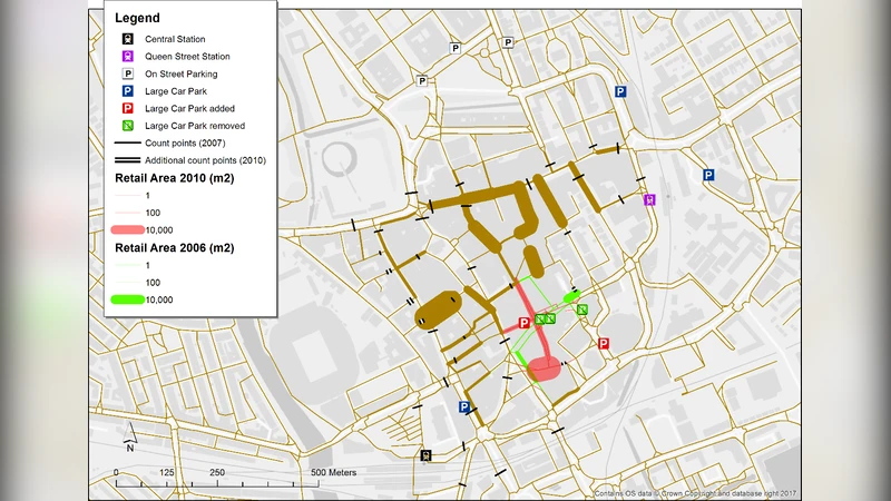
The authors introduce a Multivariate Hybrid Spatial Network Analysis (MHSpNA) framework that extends traditional betweenness‑based Spatial Network Analysis (SpNA). In classic SpNA, betweenness is computed by summing all shortest‑path flows from “everywhere to everywhere” under a distance constraint. MHSpNA modifies two key components: (1) the definition of “shortest” is replaced by a hybrid distance metric that blends Euclidean distance, angular change, and a stochastic term, reflecting realistic pedestrian route choice; (2) “everywhere” is replaced by four specific origin‑destination (O‑D) sets – (i) all origins to shops, (ii) shop‑to‑shop, (iii) railway stations to shops, and (iv) large car parks to shops. For each O‑D pair a separate betweenness surface is generated, yielding a multivariate set of flow predictors.
Data collection involved painstaking manual digitisation of the pedestrian network for 2007 and 2011 using ArcGIS and the Ordnance Survey Mastermap. Links were defined by centrelines, annotated with length and angular curvature. Retail floor‑area, station locations, and car‑park capacities were extracted from UK business‑rates databases, geocoded via the Google API, and supplemented with historic aerial photographs and local knowledge to reconstruct demolished or altered properties. Pedestrian counts were supplied by Cardiff Council for 2007, 2010 and 2011, measured on high‑traffic streets during weekend daytime periods (Friday and Saturday, 10 am‑4 pm).
The modelling workflow proceeds as follows: (a) compute the four hybrid betweenness surfaces on the 2007 network; (b) regress observed 2007 pedestrian counts against the four betweenness values using ordinary least squares; (c) employ Generalized Cross‑Validation (GCV) to select the optimal combination of predictor weights and to guard against over‑fitting; (d) apply the calibrated regression coefficients to the 2010 and 2011 networks (which incorporate the new streets, arcades, and updated retail floor‑area) to generate predicted pedestrian flows; (e) compare predictions with observed counts using the coefficient of determination (r²).
Results show that the calibrated MHSpNA model explains a substantial proportion of the variance in the 2007 data (r² ≈ 0.78). When the same coefficients are applied to the post‑development years, the predicted flows retain a high correlation with observed counts (r² ≈ 0.75‑0.80), indicating that the model successfully captures the redistribution of pedestrian traffic caused by the new layout. The “everywhere‑to‑shops” and “stations‑to‑shops” betweenness components contribute most strongly to the explanatory power, while the shop‑to‑shop and car‑park‑to‑shops components add modest but statistically significant improvements.
The authors discuss several limitations. First, pedestrian counts are limited to medium‑to‑high flow streets; low‑flow streets are under‑represented, potentially biasing calibration toward busy corridors. Second, the business‑rates data lack information on demolished premises, requiring reconstruction from ancillary sources, which may introduce errors in floor‑area estimates. Third, the model is unimodal; it does not currently account for cyclists, vehicles, or public transport interactions, although the authors note that the framework could be extended to multimodal networks.
Despite these constraints, the study demonstrates that a hybrid, multivariate betweenness approach can be calibrated on a single pre‑intervention snapshot and then extrapolated both spatially (to new network configurations) and temporally (to future years). This bridges the methodological gap between low‑cost sketch‑planning tools and data‑intensive four‑stage transport models, offering urban planners a practical instrument for assessing the vitality impact of street‑level interventions before they are built.
In conclusion, the paper provides the first longitudinal validation of a vitality‑pedestrian flow model, showing that MHSpNA can reliably forecast how major street‑layout changes reshape pedestrian movement patterns. The findings support the use of spatial‑network‑based analytics in evidence‑based town‑centre regeneration strategies, helping decision‑makers anticipate economic and social outcomes of redevelopment projects.
Comments & Academic Discussion
Loading comments...
Leave a Comment