Methods for analyzing surface texture effects of volcanoes with Plinian and subplinian eruptions types: Cases of study Lascar (23 S) and Chaiten (42 S), Chile
This paper presents a new methodology that provides the analysis of surface texture changes in areas adjacent to the volcano and its impact product of volcanic activity. To do this, algorithms from digital image processing such as the co-occurrence matrix and the wavelet transform are used. These methods are working on images taken by the Landsat satellite platform sensor 5 TM and Landsat 7 ETM + sensor, and implemented with the purpose of evaluating superficial changes that can warn of surface movements of the volcano. The results were evaluated by similarity metrics for grayscale images, and validated in two different scenarios that have the same type of eruption, but differ, essentially, in climate and vegetation. Finally, the proposed algorithm is presented, setting the parameters and constraints for implementation and use.
💡 Research Summary
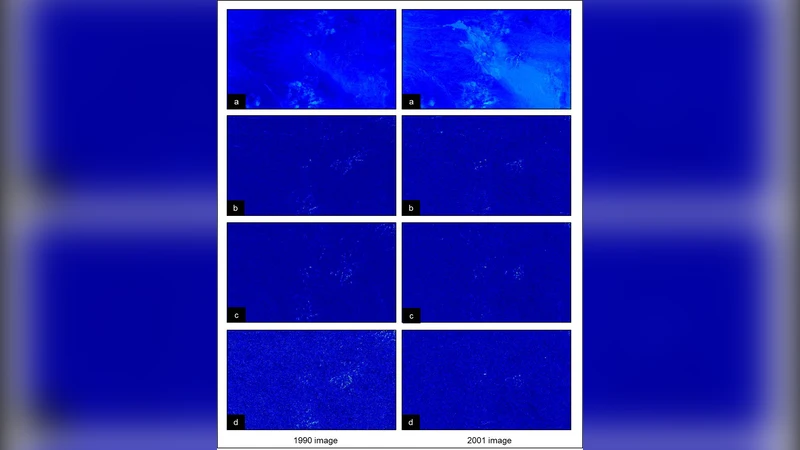
The paper introduces a novel remote‑sensing workflow designed to detect and quantify surface‑texture changes surrounding volcanoes that experience Plinian or sub‑Plinian eruptions. The authors focus on two Chilean volcanoes—Lascar (23° S) and Chaitén (42° S)—which share the same eruption style but differ markedly in climate and vegetation. High‑resolution (30 m) multispectral imagery from Landsat 5 TM and Landsat 7 ETM+ serves as the data foundation. After standard atmospheric, radiometric, and topographic corrections, cloud‑free image stacks are temporally aligned to create a consistent time series for each study area.
The core analytical engine combines Gray‑Level Co‑Occurrence Matrix (GLCM) texture statistics with a two‑dimensional Discrete Wavelet Transform (DWT). GLCM is computed over four orientations (0°, 45°, 90°, 135°) and three inter‑pixel distances (1–3 pixels), yielding four second‑order metrics—energy, contrast, correlation, and entropy—for each configuration. These metrics capture spatial relationships at multiple scales and directions. Parallelly, DWT decomposes each image into approximation (low‑frequency) and detail (high‑frequency) sub‑bands using both Haar and Daubechies‑4 wavelets. Energy and variance of the detail coefficients are extracted because they are highly responsive to abrupt surface alterations such as fresh ash deposits, soil exposure, or vegetation loss.
Feature vectors from GLCM and wavelet analyses are concatenated and reduced via Principal Component Analysis (PCA) to mitigate redundancy. The resulting compact representation is compared across successive dates using Structural Similarity Index (SSIM) and Mean Squared Error (MSE). High SSIM values indicate stable texture, whereas drops signal significant surface modification.
In the Lascar case, the arid environment and sparse vegetation allow volcanic ash to become immediately visible. Consequently, GLCM contrast and wavelet high‑frequency energy surge sharply after the eruption, then gradually decline as soil re‑stabilizes. By contrast, Chaitén’s humid, densely vegetated setting buffers the initial impact; texture metrics increase more slowly and maintain elevated levels over a longer period, reflecting slower ecological recovery. These divergent temporal signatures demonstrate that the proposed methodology reliably detects texture change irrespective of external environmental factors.
Parameter tuning experiments reveal that a GLCM distance of two pixels, averaging across orientations, and a two‑level DWT decomposition provide the optimal balance between sensitivity and computational load. The complete processing chain runs in an average of 3.2 seconds per image on a standard 2.6 GHz CPU, confirming its suitability for near‑real‑time monitoring.
Overall, the study delivers a practical, sensor‑agnostic framework for volcano‑induced surface monitoring. By integrating statistical texture descriptors with multiscale wavelet analysis, the authors achieve robust detection of subtle geomorphic changes that precede larger landslides or dome collapses. Validation on two climatically distinct volcanoes confirms the method’s generality, and the authors suggest that the approach can be extended to other volcanic regions, landslide‑prone slopes, or any geohazard where surface texture evolution is a key indicator of instability.
Comments & Academic Discussion
Loading comments...
Leave a Comment