Geographies of an online social network
How is online social media activity structured in the geographical space? Recent studies have shown that in spite of earlier visions about the 'death of distance', physical proximity is still a major
How is online social media activity structured in the geographical space? Recent studies have shown that in spite of earlier visions about the “death of distance”, physical proximity is still a major factor in social tie formation and maintenance in virtual social networks. Yet, it is unclear, what are the characteristics of the distance dependence in online social networks. In order to explore this issue the complete network of the former major Hungarian online social network is analyzed. We find that the distance dependence is weaker for the online social network ties than what was found earlier for phone communication networks. For a further analysis we introduced a coarser granularity: We identified the settlements with the nodes of a network and assigned two kinds of weights to the links between them. When the weights are proportional to the number of contacts we observed weakly formed, but spatially based modules resembling to the borders of macro-regions, the highest level of regional administration in the country. If the weights are defined relative to an uncorrelated null model, the next level of administrative regions, counties are reflected.
💡 Research Summary
The paper investigates how geographic distance shapes the structure of an online social network (OSN) by analyzing the complete user‑friend graph of the former Hungarian OSN iWiW. The authors begin by situating their work within the broader debate on the “death of distance,” noting that recent empirical studies on phone calls, instant messaging, and other digital media have revived the idea that physical proximity remains a key driver of social tie formation, even in virtual environments. However, the precise functional form of distance dependence for OSNs, especially when the full network is available, has not been firmly established.
Data collection leveraged the fact that iWiW required users to declare their place of residence in their profiles. The authors geocoded these self‑reported locations to obtain latitude‑longitude coordinates for each of roughly three million users, and they extracted the entire friendship list, which comprised tens of millions of undirected edges. This exhaustive dataset eliminates sampling bias and enables a high‑resolution spatial analysis.
The first analytical step treats each pair of users as a dyad and models the probability that an edge exists as a function of the Euclidean distance between them. Using a log‑linear regression of the form P(d) ∝ d^‑β, the authors find β ≈ 0.8. This exponent is substantially lower than the β values (≈1.5–2.0) reported for telephone call networks, indicating that online friendships decay with distance more slowly than voice communications, but the decay is still present. In other words, distance matters, but its constraining power is weakened in the OSN context.
To explore spatial patterns at a coarser scale, the authors aggregate users into settlements (towns or cities) and construct a “settlement network.” Two weighting schemes are applied to the edges between settlements:
-
Absolute weight – the raw count of friendships linking users from the two settlements. Community detection (Louvain modularity optimization) on this weighted graph reveals modules that closely follow Hungary’s macro‑regional divisions (e.g., Eastern, Central, Western clusters). This suggests that, at a broad geographic scale, online interactions still respect historically and economically defined regions.
-
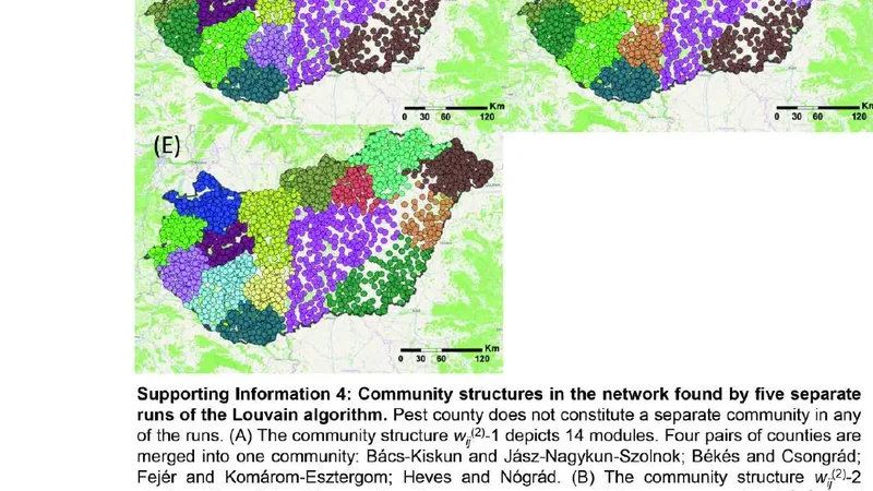
Relative weight – the observed friendship count divided by the expected count under an uncorrelated null model where ties are placed randomly with respect to distance. When this normalized weight is used, the modular structure aligns with the country’s 19 administrative counties. The relative weighting thus uncovers a finer‑grained spatial organization that is not driven merely by the sheer volume of connections but by the excess of ties beyond what would be expected given distance alone.
Additional analyses examine centrality measures across distance bins. Short‑range dyads (0–10 km) exhibit high clustering coefficients and low betweenness, indicating dense local neighborhoods. Long‑range dyads (>100 km) show reduced clustering but elevated betweenness, highlighting the role of “weak ties” that bridge distant communities—a pattern consistent with Granovetter’s theory.
The paper’s conclusions are threefold. First, OSNs display a weaker but still significant distance decay compared with traditional communication media. Second, the choice of edge weighting dramatically influences the spatial granularity of detected communities: absolute counts surface macro‑regional modules, while distance‑controlled relative counts reveal county‑level administrative boundaries. Third, online social structures are multi‑layered, simultaneously reflecting large‑scale regional cohesion and finer administrative partitions.
These findings have practical implications. Platform designers can tailor recommendation algorithms to respect both broad regional affinities and local administrative contexts. Marketers can exploit the identified spatial modules for region‑specific campaigns. Policymakers can leverage the settlement‑level network to monitor information diffusion, plan emergency communications, or assess the social impact of regional development initiatives. In sum, the study provides a rigorous, data‑driven portrait of how geography continues to shape digital social life, even as technology reduces the friction of distance.
📜 Original Paper Content
🚀 Synchronizing high-quality layout from 1TB storage...