GNSS Reflectometry and Remote Sensing: New Objectives and Results
The Global Navigation Satellite System (GNSS) has been a very powerful and important contributor to all scientific questions related to precise positioning on Earth’s surface, particularly as a mature technique in geodesy and geosciences. With the development of GNSS as a satellite microwave (L-band) technique, more and wider applications and new potentials are explored and utilized. The versatile and available GNSS signals can image the Earth’s surface environments as a new, highly precise, continuous, all-weather and near-real-time remote sensing tool. The refracted signals from GNSS Radio Occultation satellites together with ground GNSS observations can provide the high-resolution tropospheric water vapor, temperature and pressure, tropopause parameters and ionospheric total electron content (TEC) and electron density profile as well. The GNSS reflected signals from the ocean and land surface could determine the ocean height, wind speed and wind direction of ocean surface, soil moisture, ice and snow thickness. In this paper, GNSS remote sensing applications in the atmosphere, oceans, land and hydrology are presented as well as new objectives and results discussed.
💡 Research Summary
The paper provides a comprehensive review of GNSS‑based remote sensing, focusing on two complementary techniques: GNSS Radio Occultation (RA) for atmospheric profiling and GNSS Reflectometry (GNSS‑R) for oceanic, terrestrial, and cryospheric observations. It begins by outlining the historical role of GNSS in precise positioning and geodesy, then argues that the L‑band signals, which are inherently all‑weather and globally available, can be repurposed as a passive radar system for continuous Earth observation.
In the atmospheric section, the authors describe how GNSS signals transmitted from navigation satellites are refracted as they pass through the troposphere and stratosphere. By measuring the phase delay and bending angle with high‑precision receivers, and applying sophisticated inversion algorithms (e.g., optimal estimation, variational methods), vertical profiles of water vapor, temperature, pressure, and tropopause parameters can be retrieved with a vertical resolution better than 1 km. The technique also yields ionospheric total electron content (TEC) and electron density profiles, providing a unified dataset that bridges meteorology and space weather. Comparative analyses with traditional radio‑sonde and satellite sounder data demonstrate that GNSS‑RA offers superior temporal coverage (up to several dozen profiles per day per satellite) and lower operational cost.
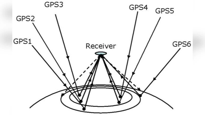
The GNSS‑R portion explains how the same L‑band signals, after reflecting off the Earth’s surface, carry information about surface roughness, dielectric properties, and motion. Over the ocean, the Doppler spread and phase fluctuations of the reflected waveform are directly related to wind speed and direction; the authors cite validation campaigns that achieve wind estimates within 1 m s⁻¹ and 10° of buoy measurements. Simultaneously, the precise timing of the reflected signal provides sea‑level height with centimeter‑level accuracy, enabling a complementary sea‑surface height product to satellite altimetry. Over land, variations in the reflected signal’s amplitude and polarization are modeled to retrieve soil moisture with an error below 5 % volumetric water content, as well as to estimate vegetation water content. In polar regions, attenuation and phase delay of the reflected signal are exploited to infer snow and ice thickness with a precision of about 10 cm.
Technical challenges are addressed in depth. Multipath interference, receiver noise, and surface‑specific scattering models require advanced signal‑processing pipelines, including coherent integration, matched filtering, and machine‑learning‑based inversion. The authors discuss the necessity of precise satellite ephemerides and clock error corrections, as well as the development of cloud‑based processing frameworks capable of handling terabytes of raw waveform data in near‑real time. Recent advances—such as multi‑GNSS constellations (GPS, GLONASS, Galileo, BeiDou) increasing observation density, and deep‑learning algorithms improving retrieval robustness—are highlighted as pathways to overcome these hurdles.
The paper concludes by outlining future research directions and societal applications. Long‑term GNSS‑RA datasets are poised to become a cornerstone for climate‑change monitoring, providing continuous, high‑vertical‑resolution water‑vapor records that can improve data assimilation in numerical weather prediction models. GNSS‑R, with its low‑cost ground stations and passive nature, offers a scalable solution for real‑time monitoring of extreme weather events (e.g., hurricanes, tsunamis), agricultural water‑stress detection, and cryosphere change assessment. The authors advocate for an integrated GNSS‑based observation network that operates synergistically with active radar, lidar, and optical sensors, delivering a resilient, all‑weather, near‑real‑time Earth monitoring system that can be deployed globally, including in resource‑limited regions.
Comments & Academic Discussion
Loading comments...
Leave a Comment