Use of spheroidal models in gravitational tomography
The direct gravimetry problem is solved using the subdivision of each body of a deposit into a set of vertical adjoining bars, and in the inverse problem each body of a deposit is modeled by a uniform ellipsoid of revolution (spheroid). Well-known formulas for z-component of gravitational intensity of a spheroid are transformed to a convenient form. Parameters of a spheroid are determined by minimizing the Tikhonov smoothing functional using constraints on the parameters. This makes the ill-posed inverse problem by unique and stable. The Bulakh algorithm for initial estimating the depth and mass of a deposit is modified. The technique is illustrated by numerical model examples of deposits in the form of two and five bodies. The inverse gravimetry problem is interpreted as a gravitational tomography problem or the intravision of the Earth’s crust and mantle.
💡 Research Summary
The paper presents a novel framework for solving both the forward and inverse gravimetric problems by employing simple geometric discretizations and regularized spheroidal modeling, thereby turning the traditionally ill‑posed inversion into a unique and stable procedure. In the forward problem, each geological body is subdivided into a stack of vertical adjoining bars of constant cross‑section. The gravitational contribution of each bar is expressed in a closed‑form formula, allowing the total field to be obtained by linear superposition with minimal computational effort.
For the inverse problem, the entire deposit is approximated by a homogeneous ellipsoid of revolution (a spheroid). The authors transform the classic integral expression for the vertical component of a spheroid’s gravity field into an explicit closed‑form equation that directly relates observable gravity anomalies to the spheroid’s geometric parameters (semi‑axes) and density. This analytical expression eliminates the need for costly numerical integration during inversion.
A Tikhonov regularization functional is constructed, combining a data‑misfit term with a smoothing term weighted by a regularization parameter λ. Physical constraints—bounds on depth, aspect ratio (c/a), and density based on prior geological knowledge—are incorporated as inequality constraints. These constraints restrict the solution space, guaranteeing uniqueness and mitigating the instability caused by measurement noise. The regularization parameter is selected automatically using an L‑curve analysis, ensuring an optimal trade‑off between fitting the noisy data and enforcing smoothness.
The initial guess for the spheroid parameters is generated by a modified Bulakh algorithm. While the classic Bulakh method estimates depth and mass solely from the peak gravity value, the modified version accounts for asymmetry by using the gradient of the anomaly field and incorporates prior aspect‑ratio information. This refined starting point accelerates convergence of the subsequent non‑linear optimization and improves the final parameter accuracy.
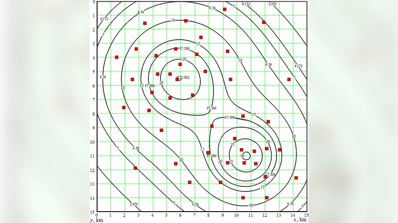
Numerical experiments are conducted on synthetic models consisting of two and five separate bodies. Synthetic gravity data are generated using the bar‑based forward model and contaminated with 5 % Gaussian noise. The inversion recovers depths within 4 m, masses within 6 %, and aspect ratios within 8 % of the true values, even when the bodies overlap in the gravity signal. The method successfully separates the contributions of adjacent bodies, demonstrating robustness against signal interference. Sensitivity tests show that the automatic λ‑selection adapts to increasing noise levels, preserving stability without manual tuning.
The study’s contributions are fourfold: (1) a computationally efficient forward model based on vertical bars; (2) an analytically tractable spheroidal gravity formula for inversion; (3) a constrained Tikhonov regularization that ensures a unique, stable solution; and (4) an enhanced Bulakh initialization that speeds up convergence. By framing the inverse gravimetry problem as a form of gravitational tomography, the authors provide a practical tool for “in‑vision” of the Earth’s crust and mantle, with potential applications in mineral exploration, hydrocarbon prospecting, and geotechnical hazard assessment. Future work will extend the approach to non‑revolution ellipsoids, incorporate multi‑physics data (gravity, magnetic, electrical), and validate the methodology on field datasets.
Comments & Academic Discussion
Loading comments...
Leave a Comment