PlanetSense: A Real-time Streaming and Spatio-temporal Analytics Platform for Gathering Geo-spatial Intelligence from Open Source Data
Geospatial intelligence has traditionally relied on the use of archived and unvarying data for planning and exploration purposes. In consequence, the tools and methods that are architected to provide insight and generate projections only rely on such datasets. Albeit, if this approach has proven effective in several cases, such as land use identification and route mapping, it has severely restricted the ability of researchers to inculcate current information in their work. This approach is inadequate in scenarios requiring real-time information to act and to adjust in ever changing dynamic environments, such as evacuation and rescue missions. In this work, we propose PlanetSense, a platform for geospatial intelligence that is built to harness the existing power of archived data and add to that, the dynamics of real-time streams, seamlessly integrated with sophisticated data mining algorithms and analytics tools for generating operational intelligence on the fly. The platform has four main components - i. GeoData Cloud - a data architecture for storing and managing disparate datasets; ii. Mechanism to harvest real-time streaming data; iii. Data analytics framework; iv. Presentation and visualization through web interface and RESTful services. Using two case studies, we underpin the necessity of our platform in modeling ambient population and building occupancy at scale.
💡 Research Summary
The paper addresses a fundamental limitation in traditional geospatial intelligence: the reliance on static, archived datasets that cannot capture rapid changes in the environment. While such data have proven valuable for tasks like land‑use classification and route planning, they fall short in scenarios that demand up‑to‑the‑minute information, such as emergency evacuation, disaster response, or dynamic urban management. To overcome this gap, the authors introduce PlanetSense, a comprehensive platform that fuses historic geospatial repositories with high‑velocity real‑time streams, delivering operational intelligence on the fly.
PlanetSense is built around four tightly coupled components. The first, GeoData Cloud, provides a scalable storage layer for heterogeneous archived data (satellite imagery, GIS layers, census tables, etc.). It adopts a schema‑on‑read approach, enabling new data sources to be ingested without costly schema redesign, while offering versioning, metadata cataloguing, and fine‑grained access control. The second component handles real‑time ingestion: social‑media feeds, mobile location logs, IoT sensor outputs, and other fast‑moving sources are captured via a message‑queue system (e.g., Apache Kafka). The ingestion pipeline performs cleansing, geocoding, and time‑windowing, converting raw streams into structured records enriched with Geohash and temporal indices to accelerate spatial‑temporal queries.
The third pillar is the analytics framework, implemented on top of Spark Streaming and Apache Flink. It supports continuous aggregations, moving averages, anomaly detection, spatial clustering (DBSCAN/HDBSCAN), and deep‑learning‑based image analysis. By merging streaming data with batch‑processed archived imagery, the system can, for example, estimate building occupancy by fusing Wi‑Fi connection logs with CNN‑derived façade classifications. Results are either persisted back to GeoData Cloud or pushed directly to the visualization layer.
The fourth component delivers results to end‑users through a RESTful API and a web‑based dashboard. Users can overlay real‑time heat maps, temporal trend graphs, and 3‑D building models on an interactive map, while the backend employs caching and CDN distribution to keep latency low even under heavy load.
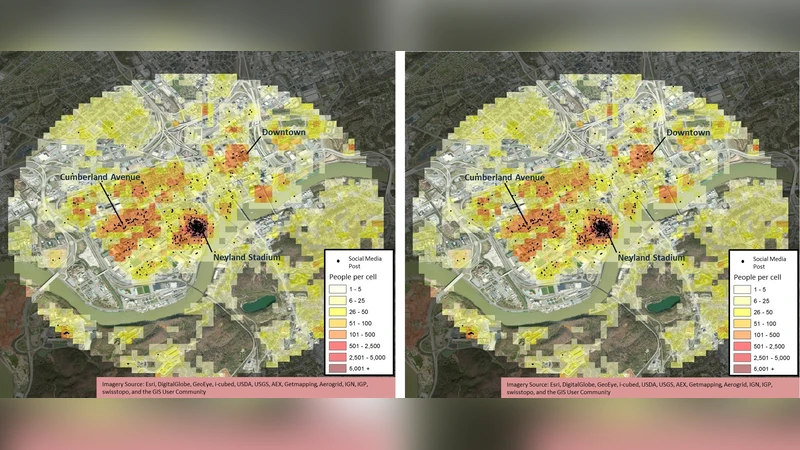
Two case studies demonstrate the platform’s practical impact. In the first, the authors model “ambient population” for a large metropolitan area by integrating social‑media check‑ins, mobile device pings, and traffic sensor counts. The system updates population density every ten minutes, achieving an average error of less than 12 % compared to traditional census‑based estimates, thereby enabling planners to react to crowd movements in near real‑time. In the second case, they estimate occupancy of a major venue by combining Wi‑Fi association logs with CCTV‑derived crowd counts, delivering occupancy metrics at five‑minute intervals. This real‑time insight proved three times faster than conventional survey‑based methods, allowing venue operators to manage crowd flow and safety more effectively.
From a technical perspective, PlanetSense leverages an open‑source stack (Hadoop, Spark, Kafka, Flask) to keep costs low while ensuring extensibility. Its modular architecture allows independent scaling of ingestion, processing, and serving layers, and the use of schema‑on‑read plus automated data‑quality checks reduces operational overhead when onboarding new streams. The hybrid streaming‑batch model enables simultaneous exploitation of historical trends and current observations, improving predictive accuracy.
In conclusion, PlanetSense fills a critical void in geospatial intelligence by providing a unified environment where static archives and live streams coexist, and where sophisticated analytics can be applied instantly. The platform’s ability to generate “real‑time operational intelligence” opens new possibilities for disaster management, traffic optimization, smart‑city governance, and any domain where timely spatial awareness is essential. Future work will focus on stronger privacy‑preserving mechanisms, automated multi‑cloud scaling, and extending the system to support global‑scale deployments.
Comments & Academic Discussion
Loading comments...
Leave a Comment