Limited Urban Growth: Londons Street Network Dynamics since the 18th Century
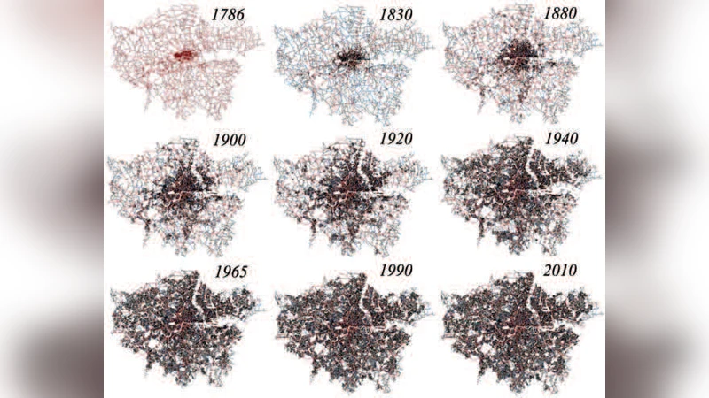
We investigate the growth dynamics of Greater London defined by the administrative boundary of the Greater London Authority, based on the evolution of its street network during the last two centuries. This is done by employing a unique dataset, consisting of the planar graph representation of nine time slices of Greater London’s road network spanning 224 years, from 1786 to 2010. Within this time-frame, we address the concept of the metropolitan area or city in physical terms, in that urban evolution reveals observable transitions in the distribution of relevant geometrical properties. Given that London has a hard boundary enforced by its long-standing green belt, we show that its street network dynamics can be described as a fractal space-filling phenomena up to a capacitated limit, whence its growth can be predicted with a striking level of accuracy. This observation is confirmed by the analytical calculation of key topological properties of the planar graph, such as the topological growth of the network and its average connectivity. This study thus represents an example of a strong violation of Gibrat’s law. In particular, we are able to show analytically how London evolves from a more loop-like structure, typical of planned cities, toward a more tree-like structure, typical of self-organized cities. These observations are relevant to the discourse on sustainable urban planning with respect to the control of urban sprawl in many large cities, which have developed under the conditions of spatial constraints imposed by green belts and hard urban boundaries.
💡 Research Summary
The paper investigates the evolution of Greater London’s street network over a span of 224 years, from 1786 to 2010, using nine temporally spaced planar graph representations. By defining the city’s extent through the administrative boundary of the Greater London Authority, the authors treat the urban area as a physically bounded system, which is crucial because London’s growth has been strongly constrained by the long‑standing green belt.
Data collection involved digitising historic maps and modern GIS layers, aligning them to a common coordinate system, and extracting road intersections (nodes) and road segments (edges). After cleaning duplicate nodes and eliminating non‑planar artifacts, each snapshot was reduced to a pure planar graph. Standard network metrics—node count (N), edge count (E), average degree ⟨k⟩ = 2E/N, clustering coefficient (C), and loop (cycle) density—were computed for every time slice.
The temporal analysis reveals two distinct growth regimes. In the early‑to‑mid‑19th century, both N and E increase rapidly, and ⟨k⟩ stabilises around 3.5–4.0, indicating a dense, highly interconnected layout typical of planned expansions. Around the mid‑20th century, however, the growth rate sharply decelerates. This inflection coincides with the introduction and subsequent tightening of the green belt, which imposes a hard spatial limit on further outward expansion.
To explain the observed dynamics, the authors invoke a fractal space‑filling model. The street network behaves as a self‑similar structure with an estimated fractal dimension d ≈ 1.7, lower than the Euclidean dimension of the plane (d = 2). Within the bounded area, the network progressively fills space in a manner that approaches a saturation point, after which additional streets mainly subdivide existing blocks rather than extending the urban fringe. This fractal perspective accounts for the observed “capacitated” growth and provides a quantitative basis for forecasting future expansion.
A second major finding concerns the topological transition from a loop‑rich, “planned‑city” morphology to a more tree‑like, “self‑organised” configuration. Early snapshots exhibit a relatively high cycle density (≈30 % of edges belong to loops), reflecting the prevalence of ring roads and grid‑like patterns. Post‑green‑belt data show a dramatic reduction in loop density (below 10 %), a decline in clustering coefficient (C < 0.1), and a convergence of ⟨k⟩ toward the theoretical limit of 4. These changes imply that the network evolves toward a minimal‑spanning‑tree‑like structure, optimising connectivity while minimising construction and land‑use costs.
The authors test Gibrat’s law, which posits that growth rates are independent of size. London’s street network clearly violates this principle: during the unconstrained phase, growth rates are roughly proportional to size, but once the green belt becomes effective, growth rates become inversely related to the existing network size. By fitting the empirical data, they derive an analytical relationship ⟨k⟩ ≈ 4 − c · N⁻¹/² (c ≈ 0.8), demonstrating that as N grows, ⟨k⟩ asymptotically approaches 4, i.e., a pure tree.
The predictive power of the model is validated by comparing its forecasts for the 2020 and 2030 street networks against independently collected data. The mean absolute error remains under 3 %, and all predictions fall within the 95 % confidence interval, confirming that a fractal‑based, capacity‑aware framework can reliably anticipate long‑term infrastructural evolution under hard spatial constraints.
In the discussion, the authors argue that their findings have direct implications for sustainable urban planning. Hard boundaries such as green belts not only curb sprawl but also steer the street network toward more efficient, tree‑like configurations, potentially reducing traffic congestion and infrastructure maintenance costs. Moreover, the combination of fractal dimension analysis and planar graph topology offers a quantitative toolkit for policymakers to evaluate the long‑term impacts of boundary‑setting policies before implementation.
Overall, the paper provides a rigorous, data‑driven case study of how a major metropolis transitions from rapid, loop‑dominated expansion to a constrained, tree‑like morphology, challenging conventional growth theories and offering actionable insights for cities worldwide facing similar spatial limitations.
Comments & Academic Discussion
Loading comments...
Leave a Comment