Model for a dune field with exposed water table
Aeolian transport in coastal areas can be significantly affected by the presence of an exposed water table. In some dune fields, such as in Len\c{c}'ois Maranhenses, northeastern Brazil, the water table oscillates in response to seasonal changes of rainfall and rates of evapotranspiration, rising above the ground during the wet season and sinking below in the dry period. A quantitative understanding of dune mobility in an environment with varying groundwater level is essential for coastal management as well as for the study of long-term evolution of many dune fields. Here we apply a model for aeolian dunes to study the genesis of coastal dune fields in presence of an oscillating water table. We find that the morphology of the field depends on the time cycle, $T_{\mathrm{w}}$, of the water table and the maximum height, $H_{\mathrm{w}}$, of its oscillation. Our calculations show that long chains of barchanoids alternating with interdune ponds such as found at Len\c{c}'ois Maranhenses arise when $T_{\mathrm{w}}$ is of the order of the dune turnover time, whereas $H_{\mathrm{w}}$ dictates the growth rate of dune height with distance downwind. We reproduce quantitatively the morphology and size of dunes at Len\c{c}'ois Maranhenses, as well as the total relative area between dunes.
💡 Research Summary
The paper presents a physically based, continuum model of aeolian dune formation that explicitly incorporates the effects of a seasonally oscillating water table. The authors focus on the coastal dune field of Lençóis Maranhenses in northeastern Brazil, where strong unidirectional easterly winds, sparse vegetation, and a shallow water table that rises during the rainy season and falls during the dry season produce a striking pattern of linked barchanoids interspersed with interdune ponds.
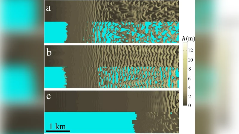
The model builds on earlier dune‑transport frameworks (Sauermann et al., 2001; Kroy et al., 2002) and adds four computational steps: (i) calculation of the spatially varying shear stress over the topography using Fourier‑based expressions derived by Weng et al. (1991), with a separation bubble at the lee side of each dune to capture flow separation; (ii) determination of the sand flux field by solving a non‑linear mass‑conservation equation that includes saturation transients, characterized by a saturated flux (q_s) and a saturation length (\ell_s); (iii) updating the surface elevation via the continuity equation and an instantaneous avalanche rule for slopes exceeding the dynamic angle of repose; and (iv) updating the water‑table elevation (h_w(t)) as a sinusoidal function with period (T_w) and amplitude (H_w). Below the water table, wind erosion is switched off; sand arriving from above is instantly deposited, mimicking the observed rapid filling of interdune ponds during the wet season.
Key parameters are the water‑table period (T_w) and the maximum water‑table height (H_w). Numerical experiments show that when (T_w) is comparable to the dune turnover time (≈1–2 years for the studied conditions), dunes have insufficient time to fully develop before the water table rises and inundates their windward faces. This leads to the formation of long chains of barchanoids that remain partially connected, while the inundated sections become interdune ponds. If (T_w) is much shorter, the water table oscillates too rapidly to affect dune morphology, and isolated barchans dominate. The amplitude (H_w) controls how high the water can rise; larger (H_w) values suppress dune growth over longer distances, resulting in lower final dune heights, whereas smaller (H_w) permits dunes to grow taller before being cut off by inundation.
The model is calibrated with field data: wind roses indicate a dominant easterly wind with velocities up to 8 m s⁻¹ and a threshold of ≈6.2 m s⁻¹; sand grain size distribution centers around 250 µm; and the observed interdune pond coverage is about 41 % of the total area. Simulations using a 1‑year water‑table period and a 1.5 m amplitude reproduce the observed dune heights (≈30 m), spacing (200–400 m), and pond fraction with good accuracy.
Beyond reproducing the present‑day morphology, the authors argue that the framework can be employed for coastal management. By artificially modifying (T_w) or (H_w) (e.g., through water‑level control structures), it may be possible to stabilize dunes against migration or to promote dune formation where needed. Moreover, the approach offers a tool for interpreting ancient dune fields in paleo‑desert environments where fluctuating groundwater may have left similar barchanoid‑pond patterns.
In summary, the study demonstrates that seasonal water‑table oscillations are a decisive factor in the long‑term evolution of coastal dune fields. The extended dune‑transport model successfully captures the coupled dynamics of wind‑driven sand transport and groundwater fluctuations, providing both a theoretical advance and a practical instrument for geomorphologists and coastal engineers.
Comments & Academic Discussion
Loading comments...
Leave a Comment