Horizon synthesis for archaeo-astronomical purposes
In this paper I describe a simple numerical procedure to compute synthetic horizon altitude profiles for any given site. The method makes use of a simplified model of local Earth’s curvature, and it is based on the availability of digital elevation models describing the topography of the area surrounding the site under study. Examples constructed using the Shuttle Radar Topographic Mission (SRTM) data (with 90m horizontal resolution) are illustrated, and compared to direct theodolite measurements. The proposed method appears to be reliable and applicable in all cases when the distance to the local horizon is larger than ~10 km, yielding a rms accuracy of ~0.1 degrees (both in azimuth and elevation). Higher accuracies can be achieved with higher resolution digital elevation models, like those produced by many modern national geodetic surveys.
💡 Research Summary
The paper presents a straightforward numerical method for generating synthetic horizon altitude profiles for any archaeological site, using publicly available digital elevation models (DEMs). The author begins by addressing two essential corrections required for accurate horizon computation: Earth’s curvature and atmospheric refraction. A simplified curvature correction (Equation 1) incorporates the local radius of curvature R and is shown to introduce less than 0.01° error for distances up to 300 km, which comfortably meets the precision needs of archaeo‑astronomy. Atmospheric refraction is treated using Bomsford’s (1980) formulation, where the refraction constant κ depends on surface pressure, temperature, and temperature lapse rate. Under typical conditions κ≈2.3 arcsec km⁻¹, yielding a modest upward shift of about 0.06° for a 100 km distant horizon.
The core of the method consists of extracting a line‑of‑sight elevation profile (LOSEP) for a chosen azimuth. Starting from the observer’s coordinates (P₀) and elevation (z₀), the algorithm steps outward in increments equal to the DEM’s horizontal sampling Δl, solving the forward geodesic problem (Vincenty, 1975) to obtain the latitude‑longitude of each successive point. At each point the DEM provides the terrain elevation z_i, which together with the distance d_i is used to compute the apparent altitude α_i after applying curvature and refraction corrections. The maximum α_i encountered along the ray defines the natural horizon altitude for that azimuth. Repeating this process for all azimuths (typically with a step Δϕ) yields a complete horizon profile α(ϕ).
The author adopts the Shuttle Radar Topography Mission (SRTM) 90 m DEM as the primary data source, citing a vertical RMS error of ≈1.8 m and a horizontal accuracy better than 20 m. Propagating the vertical error shows that at a distance of 1.5 km the resulting altitude uncertainty is about 0.1°, while the azimuthal uncertainty at 10 km is also ≈0.1°. Consequently, for horizons farther than roughly 10 km the method reliably delivers both altitude and azimuth with an RMS accuracy of ~0.1°. Higher‑resolution DEMs (e.g., ASTER 30 m, national surveys) can improve performance, especially for nearer horizons.
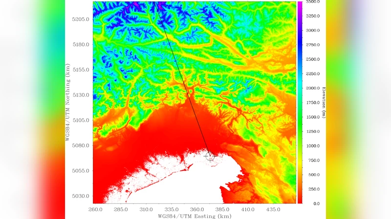
Validation is carried out on two Italian sites. At Aquileia, a LOS along 339° reaches a peak elevation of 3000 m at 140 km, but the actual horizon is found at ~100 km with an apparent altitude of 1.1°. At St. Martin (Artegna), the author compares synthetic horizons derived from both SRTM and ASTER DEMs with direct theodolite measurements. The western horizon (distance >10 km) shows discrepancies below 0.1°, confirming the method’s accuracy. The eastern horizon, however, lies within 1–2 km and is characterized by steep slopes; here the DEM’s smoothing leads to under‑estimated elevations and errors up to 1.5°. This demonstrates the limitation of 90 m DEMs for close, rugged horizons and underscores the need for higher‑resolution data in such cases.
Finally, the technique is applied to the well‑studied Neolithic site Maes Howe in Orkney, where the surrounding horizon is distant and relatively smooth. The synthetic horizon aligns well with known astronomical alignments of the monument, illustrating how the method can be integrated into archaeo‑astronomical analyses without extensive field work.
In summary, the paper delivers a practical, reproducible workflow for generating horizon profiles from global DEMs, achieving ~0.1° accuracy for horizons beyond ~10 km. It highlights the importance of DEM resolution for near‑field, steep terrain, and provides a clear path for researchers to incorporate synthetic horizons into orientation studies of ancient structures worldwide.
Comments & Academic Discussion
Loading comments...
Leave a Comment