Urban road networks -- Spatial networks with universal geometric features? A case study on Germanys largest cities
Urban road networks have distinct geometric properties that are partially determined by their (quasi-) two-dimensional structure. In this work, we study these properties for 20 of the largest German cities. We find that the small-scale geometry of all examined road networks is extremely similar. The object-size distributions of road segments and the resulting cellular structures are characterised by heavy tails. As a specific feature, a large degree of rectangularity is observed in all networks, with link angle distributions approximately described by stretched exponential functions. We present a rigorous statistical analysis of the main geometric characteristics and discuss their mutual interrelationships. Our results demonstrate the fundamental importance of cost-efficiency constraints for in time evolution of urban road networks.
💡 Research Summary
This paper investigates the geometric characteristics of urban road networks in the twenty largest German cities, aiming to determine whether small‑scale structural features exhibit universal patterns despite differences in city size, history, and topography. The authors use the 2005 TeleAtlas MultiNet™ database, a high‑resolution GIS source employed in many navigation and mapping services. After extracting the raw data, they apply a two‑step preprocessing pipeline: first, all multiple and partially directed links are merged into a single undirected link, eliminating redundancy; second, nodes of degree kₙ = 2 that represent curved or bent road sections rather than true intersections are removed, and all dead‑end roads (kₙ = 1) are discarded. This yields a clean planar graph that reflects the functional backbone of each city’s road system.
Node analysis shows that the average node degree ⟨kₙ⟩ lies between 3.17 and 3.31 across all cities, with a global mean of 3.25. Nodes of degree kₙ = 4 are markedly over‑represented, accounting for roughly 30 % of all intersections. This prevalence of four‑way junctions points to a strong tendency toward orthogonal, rectangular layouts, which are known to maximize space utilization while minimizing conflict points. The degree distribution decays rapidly, consistent with the planarity constraint that prevents the emergence of scale‑free behavior.
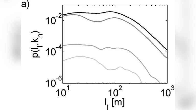
Link (road segment) statistics reveal heavy‑tailed length distributions that follow a power‑law‑like form; the mean segment length is about 110 m with a standard deviation near 35 m. Segment length correlates with node degree: links attached to four‑way intersections tend to be shorter, facilitating the formation of compact rectangular blocks. The distribution of link angles θₗ exhibits a pronounced peak at 90°, and the full angular distribution is well described by a stretched exponential f(θ) ∝ exp
Comments & Academic Discussion
Loading comments...
Leave a Comment