Investigating the Impact of Global Positioning System Evidence
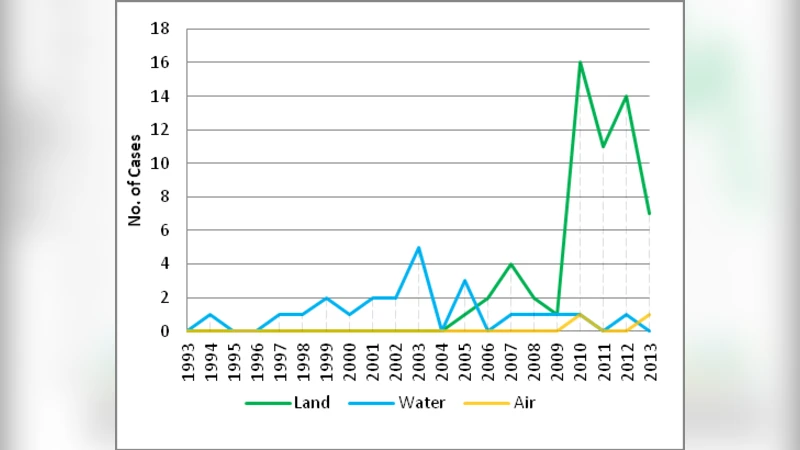
The continued amalgamation of Global Positioning Systems (GPS) into everyday activities stimulates the idea that these devices will increasingly contribute evidential importance in digital forensics cases. This study investigates the extent to which GPS devices are being used in criminal and civil court cases in the United Kingdom through the inspection of Lexis Nexis, Westlaw, and the British and Irish Legal Information Institute (BAILII) legal databases. The research identified 83 cases which involved GPS evidence from within the United Kingdom and Europe for the time period from 01 June 1993 to 01 June 2013. The initial empirical analysis indicates that GPS evidence in court cases is rising over time and the majority of those court cases are criminal cases.
💡 Research Summary
The paper provides a systematic investigation into how Global Positioning System (GPS) data have been employed as evidentiary material in United Kingdom and European courts over a twenty‑year span, from 1 June 1993 to 1 June 2013. By querying three major legal research platforms—Lexis Nexis, Westlaw, and the British and Irish Legal Information Institute (BAILII)—the authors identified 83 judicial decisions in which GPS evidence was explicitly referenced. The methodology involved constructing a comprehensive set of search terms (e.g., “GPS,” “global positioning system,” “navigation,” “location data”) and then manually reviewing each retrieved judgment to confirm that GPS data were actually admitted, to classify the type of case (criminal, civil, or administrative), and to describe the form of the evidence (raw device logs, extracted navigation files, real‑time tracking records, or expert testimony based on such data).
The quantitative findings reveal a clear upward trajectory in the use of GPS evidence. While only a handful of cases appeared in the early 1990s, the number of reported instances rose sharply after the early 2000s, coinciding with the proliferation of consumer‑grade GPS devices, in‑vehicle navigation units, and later, smartphones equipped with location services. By 2008 the annual count of GPS‑related cases had roughly doubled, and the overall trend continued upward through the end of the study period. Of the 83 cases, 62 (approximately 75 %) were criminal matters, with the remainder being civil or administrative disputes. In criminal proceedings, GPS data were most frequently used to establish a suspect’s presence at a particular location, to reconstruct routes taken during alleged offenses, or to verify whether a vehicle was within a prohibited zone at a specific time. Civil cases leveraged GPS evidence for insurance claims, boundary disputes, contract performance verification, and similar factual determinations.
From a legal perspective, the authors examine the admissibility and reliability standards applied by UK courts to GPS evidence. The prevailing judicial attitude is that GPS data are admissible provided they are derived in accordance with recognized scientific and technical principles and that a proper chain of custody is documented. Nevertheless, the paper highlights recurring challenges: potential data tampering, satellite signal degradation, clock drift, and device‑specific inaccuracies. Consequently, expert testimony is often required to explain the methodology of data extraction, to quantify error margins, and to demonstrate that the data have not been altered post‑collection. The authors also discuss privacy considerations, noting that GPS information is classified as personal data under the UK Data Protection Act 1998 and, subsequently, the General Data Protection Regulation (GDPR). Courts have occasionally excluded GPS evidence when the collection process failed to meet statutory safeguards, such as obtaining a valid warrant or adhering to the principle of data minimisation.
The paper concludes with practical recommendations for digital forensic practitioners. First, forensic analysts should preserve original device images, calculate cryptographic hashes, and maintain meticulous chain‑of‑custody logs. Second, they should corroborate GPS timestamps with auxiliary sources (e.g., Network Time Protocol logs, cellular tower records) to mitigate clock‑drift issues. Third, expert witnesses must be prepared to articulate device specifications, known error rates, and any corrective algorithms applied during analysis.
Looking ahead, the authors propose several avenues for further research. One promising direction is the integration of GPS data with other location‑based services (Wi‑Fi positioning, Bluetooth beacons, cellular triangulation) to create richer, cross‑validated location histories. Another is the development of machine‑learning models capable of automatically detecting anomalous patterns indicative of data manipulation or of extracting salient route segments relevant to a case. Such advances could streamline the forensic workflow, enhance the evidentiary weight of location data, and ultimately support more accurate and equitable judicial outcomes.
Comments & Academic Discussion
Loading comments...
Leave a Comment