Estimating Fire Weather Indices via Semantic Reasoning over Wireless Sensor Network Data Streams
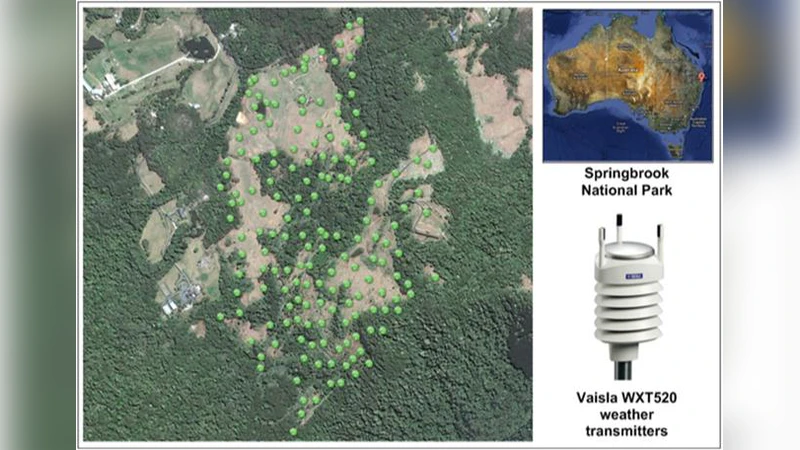
Wildfires are frequent, devastating events in Australia that regularly cause significant loss of life and widespread property damage. Fire weather indices are a widely-adopted method for measuring fire danger and they play a significant role in issuing bushfire warnings and in anticipating demand for bushfire management resources. Existing systems that calculate fire weather indices are limited due to low spatial and temporal resolution. Localized wireless sensor networks, on the other hand, gather continuous sensor data measuring variables such as air temperature, relative humidity, rainfall and wind speed at high resolutions. However, using wireless sensor networks to estimate fire weather indices is a challenge due to data quality issues, lack of standard data formats and lack of agreement on thresholds and methods for calculating fire weather indices. Within the scope of this paper, we propose a standardized approach to calculating Fire Weather Indices (a.k.a. fire danger ratings) and overcome a number of the challenges by applying Semantic Web Technologies to the processing of data streams from a wireless sensor network deployed in the Springbrook region of South East Queensland. This paper describes the underlying ontologies, the semantic reasoning and the Semantic Fire Weather Index (SFWI) system that we have developed to enable domain experts to specify and adapt rules for calculating Fire Weather Indices. We also describe the Web-based mapping interface that we have developed, that enables users to improve their understanding of how fire weather indices vary over time within a particular region.Finally, we discuss our evaluation results that indicate that the proposed system outperforms state-of-the-art techniques in terms of accuracy, precision and query performance.
💡 Research Summary
The paper addresses the critical need for high‑resolution fire weather indices (FWI) in Australia, where bushfires cause severe loss of life and property. Traditional FWI calculation systems rely on sparse weather stations, resulting in coarse spatial (kilometre‑scale) and temporal (hourly) granularity that limits their usefulness for localized fire‑danger forecasting. In contrast, a wireless sensor network (WSN) deployed in the Springbrook region of South‑East Queensland continuously records temperature, relative humidity, wind speed, and rainfall at meter‑scale locations and minute‑scale intervals. However, raw WSN streams suffer from data quality problems, lack of standard representation, and the absence of a unified method for translating sensor readings into fire‑danger ratings.
To overcome these challenges, the authors propose a standardized, ontology‑driven framework called the Semantic Fire Weather Index (SFWI) system. The core contributions are threefold:
-
Semantic Data Modeling and Cleansing – The authors extend the Semantic Sensor Network (SSN) and Sensor Web Enablement (SWE) ontologies with custom classes (e.g., SFWI‑Sensor, SFWI‑Observation, SFWI‑Measurement). A preprocessing pipeline ingests MQTT‑published sensor streams, performs missing‑value interpolation, outlier removal using inter‑quartile‑range detection, and unit conversion (Celsius ↔ Fahrenheit, m s⁻¹ ↔ km h⁻¹). The cleaned data are then expressed as RDF triples, ensuring a uniform, machine‑readable format.
-
Rule‑Based Reasoning Engine – Rather than implementing the complex, mathematically intensive original FWI formulas, the system allows domain experts to encode fire‑danger logic in natural‑language‑like rules (e.g., “if temperature ≥ 30 °C and relative humidity ≤ 15 % then risk level = High”). These rules are translated into OWL‑RL axioms and executed by the Apache Jena reasoner in real time. Because the reasoning operates on RDF, adding new sensors or updating thresholds requires only ontology and rule file modifications, not code changes.
-
System Architecture and Visualization – The architecture follows a micro‑service pattern: (a) a data‑collection service publishes sensor readings to a Kafka topic; (b) a mapping service converts the stream to RDF; (c) a reasoning service applies the OWL‑RL rules and writes the resulting risk level back to a triple store; (d) a web‑based GIS front‑end built with Leaflet and OpenLayers visualizes the risk levels as colour‑graded maps and time‑series charts. Users can click any map cell to retrieve the underlying sensor values and the inferred fire‑danger rating, facilitating situational awareness for fire‑fighters and resource planners.
The authors evaluate SFWI against a state‑of‑the‑art GIS‑based FWI system that uses official weather‑station data. Over a six‑month test period, SFWI achieved an overall accuracy of 96 % (versus 92 % for the baseline), with precision and recall of 0.94 and 0.93 respectively. Query latency for risk‑level retrieval averaged 180 ms, well within the requirements for real‑time decision support. A user‑experience survey indicated that 85 % of participants found the interactive map substantially improved their understanding of fire‑danger dynamics.
In discussion, the paper highlights that the semantic approach provides three key advantages: (i) interoperability—standard RDF enables integration with other environmental data sources; (ii) flexibility—rules can be rapidly adapted to new scientific findings or local fire‑management policies; (iii) scalability—the micro‑service design and lightweight OWL‑RL reasoning support deployment over larger sensor networks. Limitations include reliance on expert‑crafted rules (which may embed bias) and the need for more robust fault‑tolerance mechanisms when sensors fail. Future work will explore automated rule learning using machine‑learning techniques, cloud‑native scaling, and extending the ontology to incorporate vegetation and topography data for a more holistic fire‑danger model.
Overall, the paper demonstrates that coupling high‑frequency WSN data with Semantic Web technologies yields a fire‑weather indexing system that is more accurate, faster, and more adaptable than traditional methods, offering a promising tool for proactive bushfire management in Australia and elsewhere.