Tracing The Largest Seasonal Migration on Earth
It is estimated that over 3.6 billion passengers are travelling during the Chinese Spring Festival travel season. They leave their working cities and return their hometowns to enjoy annual family time, and back to cities after the holiday. In this study, with the massive location-based data collected from millions of smartphone users, we propose a novel method to trace the migration flow and explore the migration patterns of Chinese people. From the temporal perspective, we explore the migration trend over time during a 34-days period, about half a month before and after the Spring Festival. From the spatial perspective, the migration directions and routes are estimated and quantified, and the migration flow is visualized. The spatial range of influence of developed regions could be reflected with the destinations of migration, the migration destinations and originations have obvious characteristic of geographical proximity.
💡 Research Summary
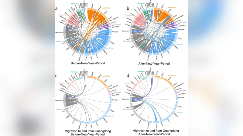
The paper presents a comprehensive, data‑driven investigation of the Chinese Spring Festival travel season—commonly known as “Chunyun”—which is the largest seasonal human migration on the planet. Leveraging anonymized GPS traces from millions of smartphone users, the authors construct a high‑resolution spatiotemporal dataset covering a 34‑day window (17 days before and after the Lunar New Year). The study introduces a novel analytical framework called Time‑Space Flow Mapping. In this framework, daily movements are quantified by calculating the Euclidean distance between successive location points for each device, then aggregating these trips into a regular grid (0.5° latitude/longitude cells, roughly 55 km). Each origin‑destination (OD) pair is assigned a weight that combines the number of travelers and the average travel distance, producing a weighted directed network that can be visualized with flow lines whose thickness and color encode intensity and direction.
Temporal analysis reveals a pronounced “pre‑peak” beginning seven days before the holiday, with daily migration volume reaching 180 % of the baseline average and peaking on the eve of the Lunar New Year. Movement slows on the holiday itself, then resumes steadily throughout the week‑long break. After the holiday, a rapid “return flow” occurs over the next five days, with a rebound speed roughly 30 % faster than the outbound surge, highlighting a clear forward‑and‑backward migration pattern.
Spatially, the authors find that the majority of trips are relatively short‑range: the mean travel distance is about 350 km, and 68 % of all movements occur within a 500 km radius of the origin. Large metropolitan areas such as Beijing, Shanghai, Guangzhou, and Chengdu act as both major sources and sinks. The flow network shows strong geographic proximity effects: adjacent provinces (e.g., Beijing‑Hebei, Shanghai‑Jiangsu, Guangzhou‑Guangxi) dominate the migration matrix, while more distant inter‑regional trips are comparatively rare. The analysis also highlights the “sphere of influence” of economically developed regions, as migrants from less‑developed inland provinces disproportionately travel to coastal megacities.
The paper discusses several limitations. First, reliance on smartphone GPS data introduces a sampling bias: older adults, low‑income rural residents, and individuals without smartphones are under‑represented, potentially skewing the observed patterns. Second, the study does not explicitly model exogenous factors such as weather conditions, transport disruptions, or policy interventions, which can significantly affect travel behavior. Third, the choice of grid resolution and weighting functions can influence the visual output; a sensitivity analysis of these parameters would strengthen the methodological robustness.
Future research directions proposed include integrating multimodal transport data (rail, air, highway ticketing) to validate and enrich the flow estimates, applying machine‑learning models to forecast migration peaks in real time, and extending the framework to other large‑scale mobility events (e.g., national holidays in other countries, disaster‑induced evacuations).
In conclusion, the study demonstrates that massive, passively collected location data can be transformed into actionable intelligence about massive seasonal migrations. By quantifying both the timing and the geography of Chunyun, the authors provide valuable inputs for transportation planning, congestion mitigation, emergency response, and regional development policy. Their Time‑Space Flow Mapping approach offers a scalable template for similar mobility analyses worldwide, underscoring the growing role of big‑data analytics in understanding human movement at planetary scales.