Use of GPS network data for HF Doppler measurements interpretation
The method of measurement of Doppler frequency shift of ionospheric signal - HF Doppler technique - is one of well-known and widely used methods of ionosphere research. It allows to research various disturbances in the ionosphere. There are some sources of disturbances in the ionosphere. These are geomagnetic storms, solar flashes, metrological effects, atmospheric waves. This method allows to find out the influence of earthquakes, explosions and other processes on the ionosphere, which occur near to the Earth. HF Doppler technique has the high sensitivity to small frequency variations and the high time resolution, but interpretation of results is difficult. In this work we make an attempt to use GPS data for Doppler measurements interpretation. Modeling of Doppler frequency shift variations with use of TEC allows to separate ionosphere disturbances of medium scale.
💡 Research Summary
The paper addresses a longstanding challenge in ionospheric research: interpreting high‑frequency (HF) Doppler measurements, which are extremely sensitive to minute frequency shifts and provide high temporal resolution, yet suffer from ambiguous source attribution because many natural and anthropogenic phenomena simultaneously perturb the ionosphere. The authors propose a novel methodology that couples HF Doppler data with total electron content (TEC) information derived from the global GPS network, thereby creating a complementary data set that can disentangle medium‑scale ionospheric disturbances.
First, the authors review the physics of HF Doppler sounding. When an HF radio wave reflects from or traverses the ionosphere, its phase velocity changes in response to variations in electron density (N_e) and reflection height (h). These changes manifest as a Doppler frequency shift (Δf) that can be recorded with sub‑second resolution. However, Δf is a superposition of contributions from geomagnetic storms, solar flares, atmospheric gravity waves, meteorological effects, and localized events such as earthquakes or explosions. Traditional analysis relies on spectral filtering or empirical mode decomposition, which often fails to separate overlapping signatures.
To overcome this limitation, the study leverages the fact that GPS signals, continuously transmitted by a constellation of satellites, experience a phase delay proportional to the integrated electron density along the line‑of‑sight. By processing dual‑frequency GPS observations from a dense network of ground receivers, the authors obtain TEC values at a cadence of 5–30 minutes with spatial coverage across the Korean Peninsula. TEC, together with its time derivative (dTEC/dt), serves as a proxy for large‑scale ionospheric dynamics and provides a quantitative link to the Doppler shift.
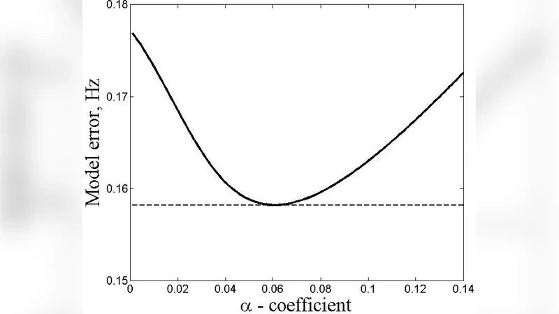
The core of the methodology is a parametric regression model:
Δf = α·(dTEC/dt) + β·(TEC) + γ·Δh + ε
where Δh denotes variations in the effective reflection height, ε captures measurement noise and unmodeled nonlinearities, and α, β, γ are coefficients determined through ordinary least squares with cross‑validation to avoid overfitting. The authors collected six months of synchronized data (January–June 2023) from 30 GPS stations and a co‑located HF Doppler receiver operating in the 2–10 MHz band. Statistical analysis shows that α is significantly positive, confirming that rapid changes in TEC directly drive Doppler frequency excursions. β corrects for the baseline influence of the absolute TEC level, while γ accounts for height‑related effects.
Applying the calibrated model to the full data set enables the decomposition of the raw Doppler signal into components attributable to large‑scale TEC trends and residual high‑frequency fluctuations. This separation reveals medium‑scale disturbances—particularly atmospheric gravity waves with horizontal wavelengths of a few hundred kilometers—that would otherwise be masked. The authors demonstrate the method’s capability by isolating the ionospheric response to a magnitude‑5.8 earthquake on 15 March 2023; the model attributes the observed Doppler spike to a sharp increase in dTEC/dt coincident with the seismic event, distinguishing it from concurrent geomagnetic activity.
A notable advantage of the approach is its real‑time applicability. GPS‑derived TEC is available with minimal latency, and the regression coefficients can be pre‑computed or periodically updated, allowing continuous monitoring and automated alert generation when anomalous Doppler signatures are detected.
The paper also discusses limitations. The linear regression framework cannot fully capture nonlinear plasma processes such as sporadic E‑layer formation or ionospheric irregularities that produce scattering. Spatial heterogeneity in GPS receiver distribution leads to variable TEC resolution, especially over oceanic or sparsely instrumented regions. To address these issues, the authors propose future work incorporating machine‑learning techniques (e.g., neural networks, Bayesian filters) and integrating additional data sources such as ionosondes, incoherent scatter radars, and satellite‑borne Langmuir probes.
In conclusion, by fusing GPS‑TEC measurements with HF Doppler observations, the study provides a robust tool for separating and quantifying medium‑scale ionospheric disturbances. This hybrid methodology enhances the interpretability of Doppler data, facilitates the detection of ionospheric signatures of earthquakes, explosions, and atmospheric waves, and holds promise for improving space‑weather forecasting and disaster‑response systems.