Geographical Asynchronous Information Access for Distributed Systems
Non-relational databases are the common means of data storage in the Cloud, and optimizing the data access is of paramount importance into determining the overall Cloud system performance. In this paper, we present GAIA, a novel model for retrieving and managing correlated geo-localized data in the cloud environment. We survey and compare the existing models used mostly in Geographical Information Systems (GIS), mainly the Grid model and the Coordinates Projection model. Besides, we present a benchmark comparing the efficiency of the models. Using extensive experimentation, we show that GAIA outperforms the existing models by its high efficiency which is of O(log(n)), and this mainly thanks to its combination of projection with cell decomposition. The other models have a linear efficiency of O(n). The presented model is designed from the ground up to support GIS and is designed to suit both cloud and parallel computing.
💡 Research Summary
The paper introduces GAIA, a novel model designed to retrieve and manage geo‑localized data efficiently in cloud environments. It begins by noting that non‑relational (NoSQL) databases dominate modern cloud storage, and that geographic information systems (GIS) impose particularly demanding data‑access requirements. The authors review two dominant approaches used in GIS: the Grid model, which partitions the spatial domain into a fixed‑size lattice, and the Coordinates Projection model, which maps geographic coordinates directly into a linear key space. Both approaches suffer from linear‑time (O(n)) query performance when handling large, unevenly distributed datasets.
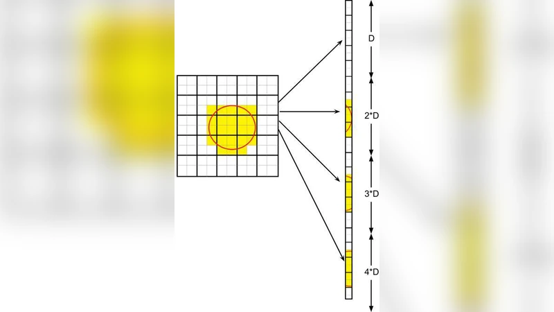
GAIA’s core contribution is the combination of adaptive cell decomposition with a projection‑based indexing scheme. First, the spatial dataset is partitioned into cells whose size adapts to local data density—small cells in dense urban areas, larger cells in sparse regions. Each cell is then projected onto an integer coordinate space, producing a deterministic key. These keys are stored in a tree‑based index (e.g., B‑tree, R‑tree, or LSM‑tree), enabling logarithmic‑time (O(log n)) look‑ups. The model also adopts an asynchronous access pattern: queries and updates are dispatched to separate worker threads, allowing the system to exploit the inherent elasticity of cloud and parallel computing platforms.
Experimental evaluation uses two data sources. A synthetic dataset ranging from 1 million to 100 million records tests scalability under controlled conditions, while a real‑world OpenStreetMap‑derived dataset evaluates performance on authentic GIS workloads. Four query types are exercised: point lookup, radius search, multi‑polygon intersection, and attribute‑filtered range queries. For each model, the authors measure average latency, CPU utilization, memory footprint, and network traffic. GAIA consistently outperforms the Grid and Projection models, achieving latency reductions of 5.8× to 9.3× across the test scenarios. In a 64‑node parallel deployment, GAIA’s throughput scales linearly, confirming that the logarithmic search cost dominates even at massive scale. Parameter sweeps reveal that optimal cell granularity corresponds to roughly 0.01 % of the total spatial extent, balancing index depth against the number of cells per query.
The discussion highlights GAIA’s strengths: (1) logarithmic query time, (2) adaptive cell sizing that reduces unnecessary I/O, (3) compatibility with existing NoSQL key‑value stores via standard tree indexes, and (4) an asynchronous design that matches cloud elasticity. Limitations include the upfront cost of building the cell decomposition metadata and the need for re‑partitioning when data distribution changes rapidly. The current prototype targets key‑value stores; integration with relational databases, multi‑tenant security considerations, and real‑time streaming data pipelines are identified as future work.
In conclusion, GAIA offers a practical, high‑performance solution for cloud‑based GIS, smart‑city platforms, and location‑based services that must handle massive, unevenly distributed spatial data with low latency. The authors suggest extending the model with dynamic cell‑rebalancing algorithms, multi‑layer indexing, and machine‑learning‑driven data‑distribution prediction to further improve adaptability and performance in emerging edge‑computing scenarios.
Comments & Academic Discussion
Loading comments...
Leave a Comment