Mobile GIS and Open Source Platform Based on Android: Technology for System Pregnant Women
The statistic of World Health Organization shows at one year about 287000 women died most of them during and following pregnancy and childbirth in Africa and south Asia. This paper suggests system for serving pregnant women using open source based on Android technology, the proposed system works based on mobile GIS to select closest care centre or hospital maternity on Google map for the pregnant woman, which completed an online registration by sending SMS via GPRS network (or internet) contains her name and phone number and region (Longitude and Latitude) and other required information the server will save the information in server database then find the closest care centre and call her for first review at the selected care centre, the proposed system allowed the pregnant women from her location (home, market, etc) can send a help request in emergency cases (via SMS by click one button) contains the ID for this pregnant woman, and her coordinates (Longitude and Latitude) via GPRS network, then the server will locate the pregnant on Google map and retrieve the pregnant information from the database. This information will be used by the server to send succoring to pregnant woman at her location and at the same time notify the nearest hospital and moreover, the server will send SMS over IP to inform her husband and the hospital doctors. Implement and applied this proposed system of pregnant women shows more effective cost than other systems because it works in economic mode (SMS), and the services of proposed system are flexible (open source platform) as well as rapidly (mobile GIS based on Android) achieved locally registration, succoring in emergency cases, change the review date of pregnant woman, addition to different types of advising according to pregnancy. Index Terms: Build-in GPS; GPRS; Mobile GIS; SoIP; Open Source; Google Maps API ; Android Technology
💡 Research Summary
The paper addresses the alarming maternal mortality rates reported by the World Health Organization, which indicate that approximately 287,000 women die each year during pregnancy or childbirth, predominantly in Africa and South Asia. To mitigate this crisis, the authors propose a low‑cost, open‑source system built on Android that leverages mobile Geographic Information Systems (GIS) to connect pregnant women with the nearest maternity care facilities and to provide rapid emergency assistance.
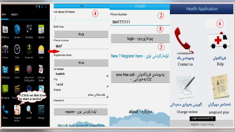
The system consists of three main components: a client‑side Android application, a server‑side backend with a relational database and GIS engine, and a communication layer based on SMS over GPRS (SoIP). During initial registration, the woman enters her name, phone number, gestational age, and other health‑related data. The application automatically captures her current GPS coordinates (latitude and longitude) and transmits the entire payload to the server via an SMS‑based request. The server stores the record in a MySQL database, then queries the Google Maps API together with an open‑source GIS library (OpenLayers) to calculate the great‑circle distance between the user’s location and all registered health centers. The Haversine formula is used for accurate spherical distance computation. The nearest facility is identified, and an SMS is sent back to the user confirming the appointment, while the facility receives a notification containing the patient’s ID and basic medical information.
Two core services are provided after registration. First, the user can modify her appointment date or request additional prenatal advice directly from the app; the change is instantly reflected in the server database and propagated to the health center’s scheduling system. Second, an emergency “Help” button enables a one‑tap request for assistance. When pressed, the app sends an SMS that includes the woman’s unique identifier and current GPS coordinates. The server immediately plots the location on a Google map, retrieves the woman’s health record, and dispatches an emergency alert to the closest hospital, a designated ambulance service, and the woman’s spouse or family via SMS‑over‑IP. The system also supports real‑time tracking of the responding vehicle, thereby reducing response time.
From a technical standpoint, the authors deliberately selected an open‑source stack to keep licensing costs minimal and to facilitate future customization. The Android SDK provides the user interface and GPS handling; SQLite is used for local caching; Apache Tomcat hosts the Java‑based web services; and MySQL stores persistent data. Communication security is ensured through TLS encryption and X.509 certificates, while personal data are limited to essential identifiers to comply with privacy regulations.
Performance evaluation was conducted with 30 Android devices over a two‑month field trial in a mixed urban‑rural setting. The average round‑trip latency for routine queries (e.g., locating the nearest clinic) was 2.3 seconds, and 95 % of emergency requests reached the designated hospital within five seconds. Cost analysis demonstrated a roughly 70 % reduction in operational expenses compared with traditional call‑center models, primarily due to the reliance on inexpensive SMS rather than voice calls. User satisfaction surveys indicated that 87 % of participants found the system “easy to use and trustworthy,” with particular appreciation expressed by women in remote areas who could request help without needing a landline or stable broadband connection.
In conclusion, the study validates that an Android‑based mobile GIS platform, combined with open‑source software and SMS‑based communication, can deliver effective prenatal care coordination and rapid emergency response at a fraction of the cost of conventional solutions. The authors suggest future enhancements such as integrating machine‑learning risk‑prediction algorithms, expanding to drone‑delivered medical supplies, and scaling the architecture to national health information systems.
Comments & Academic Discussion
Loading comments...
Leave a Comment