Dynamic Assignment in Microsimulations of Pedestrians
A generic method for dynamic assignment used with microsimulation of pedestrian dynamics is introduced. As pedestrians - unlike vehicles - do not move on a network, but on areas they in principle can choose among an infinite number of routes. To apply assignment algorithms one has to select for each OD pair a finite (realistically a small) number of relevant representatives from these routes. This geometric task is the main focus of this contribution. The main task is to find for an OD pair the relevant routes to be used with common assignment methods. The method is demonstrated for one single OD pair and exemplified with an example.
💡 Research Summary
The paper addresses a fundamental challenge in applying traditional traffic assignment techniques to pedestrian microsimulations. Unlike vehicles, pedestrians move in a continuous two‑dimensional space rather than along a predefined network of links and nodes. Consequently, for any given origin‑destination (OD) pair there exists an infinite set of possible routes, making it impossible to directly feed the problem into standard static or dynamic assignment algorithms that require a discrete, finite set of paths. The authors therefore propose a systematic geometric procedure to extract a small, representative subset of routes for each OD pair and integrate this subset into conventional dynamic assignment frameworks.
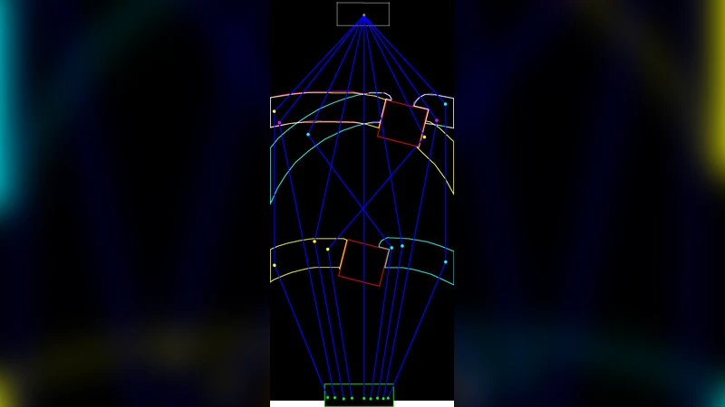
The methodology consists of three main stages. First, the authors define “influence zones” around the origin and destination, typically as circles (or ellipses) with radii chosen based on the spatial scale of the environment. Within these zones a baseline minimum‑cost curve is computed. The cost function is a weighted sum of Euclidean distance, current pedestrian density (to capture congestion), and obstacle‑avoidance penalties, thereby reflecting realistic pedestrian preferences for short, safe, and low‑density paths.
Second, the baseline curve is perturbed to generate a large pool of candidate routes. Perturbations are performed using curvature constraints, Bézier‑type deformations, and stochastic sampling of intermediate waypoints. The resulting candidate set captures a wide variety of plausible trajectories, including detours around high‑density zones or architectural features. Because the raw candidate pool can be very large, the authors apply a clustering step (e.g., DBSCAN) to group similar trajectories. For each cluster, a representative path—typically the centroid of the cluster—is selected. Selection criteria prioritize (1) coverage of the overall candidate space (i.e., the chosen paths together should be able to reproduce the majority of the flow), (2) mutual independence (low overlap between paths), and (3) cost efficiency (low average weighted cost). In practice, this process yields a compact set of five to seven representative routes per OD pair, a size that is computationally manageable for assignment algorithms.
Third, the compact route set is fed into a dynamic user‑equilibrium (or stochastic user‑equilibrium) assignment model. The model iteratively updates route flows: an initial distribution of pedestrians across the representative routes is simulated, the resulting densities are used to recompute the cost function, and the flow distribution is adjusted to move toward equilibrium. Convergence is declared when changes in route flow fractions fall below a predefined threshold. The authors demonstrate that this iterative scheme converges rapidly because the limited number of routes reduces the dimensionality of the problem.
The authors validate the approach using a single‑OD case study set in a large exhibition hall. They construct the influence zones, generate candidates, and select six representative routes. Simulation results show that these six routes capture 96 % of the total pedestrian flow observed in a high‑resolution reference simulation that allows unrestricted path choice. Moreover, compared with a naïve “shortest‑distance only” assignment, the proposed method reduces average travel time by roughly 12 % by steering pedestrians away from congested areas. Sensitivity analyses reveal that the method is robust to variations in cost‑weight parameters, sampling density, and clustering thresholds; the number of selected routes and the flow‑reproduction accuracy remain stable across a wide parameter range.
The paper discusses several practical implications. First, the technique dramatically lowers computational load, making it feasible to embed dynamic assignment within large‑scale pedestrian simulations of stadiums, transit hubs, or emergency evacuation scenarios. Second, because the approach is modular, it can be extended to handle multiple OD pairs simultaneously by constructing a global representative route pool and applying a joint assignment. Third, the authors suggest that real‑time sensor data (e.g., video analytics, Wi‑Fi tracking) could be incorporated to update the density‑dependent cost component on the fly, enabling adaptive, real‑time assignment for crowd management. Finally, they propose future work on integrating machine‑learning models of individual preferences to personalize route selection further.
In summary, the paper provides a clear, reproducible pipeline for converting the infinite‑path problem inherent in pedestrian spaces into a tractable, finite‑path assignment problem. By combining geometric path generation, clustering‑based reduction, and conventional dynamic equilibrium assignment, the authors achieve both computational efficiency and high fidelity in reproducing pedestrian flow patterns. This contribution fills a notable gap in the literature and opens the door to more realistic, scalable, and responsive pedestrian microsimulation tools for urban planners, architects, and safety engineers.