Data management and analysis with WRF and SFIRE
We introduce several useful utilities in development for the creation and analysis of real wildland fire simulations using WRF and SFIRE. These utilities exist as standalone programs and scripts as well as extensions to other well known software. Python web scrapers automate the process of downloading and preprocessing atmospheric and surface data from common sources. Other scripts simplify the domain setup by creating parameter files automatically. Integration with Google Earth allows users to explore the simulation in a 3D environment along with real surface imagery. Postprocessing scripts provide the user with a number of output data formats compatible with many commonly used visualization suites allowing for the creation of high quality 3D renderings. As a whole, these improvements build toward a unified web application that brings a sophisticated wildland fire modeling environment to scientists and users alike.
💡 Research Summary
The paper presents a comprehensive suite of utilities designed to streamline the entire workflow of wildland fire modeling using the Weather Research and Forecasting (WRF) model coupled with the SFIRE fire‑spread module. Recognizing that traditional WRF‑SFIRE simulations involve labor‑intensive steps—manual acquisition of atmospheric and surface datasets, cumbersome format conversions, hand‑crafted domain configuration files, and fragmented visualization pipelines—the authors develop a set of Python‑based tools that automate each stage from data ingestion to high‑quality 3D rendering.
The first component is a web‑scraping framework that periodically pulls the latest forecast and environmental data from public repositories such as NOAA’s Global Forecast System, NASA’s MODIS, and USGS’s National Elevation Dataset. The scraper normalizes disparate formats (NetCDF, GeoTIFF, CSV), performs coordinate transformations, temporal alignment, missing‑value interpolation, and optional compression, delivering ready‑to‑use inputs for WRF.
Next, a domain‑setup script takes user‑specified geographic bounds, simulation period, grid resolution, and fire ignition parameters, then automatically generates all required namelist files for both WRF and SFIRE. The script supports both a graphical user interface and a command‑line interface, allowing users of varying expertise to customize physical parameterizations (boundary‑layer schemes, microphysics, etc.) without editing raw text files.
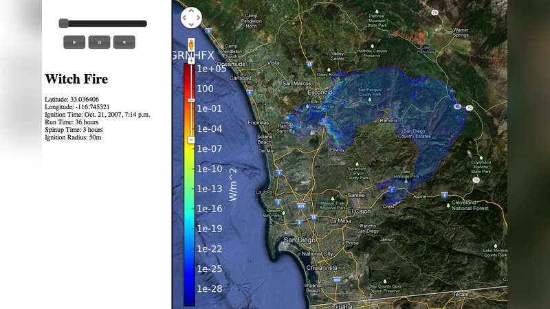
Integration with Google Earth is achieved by converting simulation outputs into KML/KMZ packages. Users can overlay fire spread, heat flux, and fuel consumption on real satellite imagery, navigate the scene in three dimensions, and animate the progression through a time slider. This capability bridges the gap between technical model results and intuitive visual communication for stakeholders such as fire managers and policy makers.
For post‑processing, the authors provide conversion utilities that export results into formats compatible with popular visualization suites: VTK and XDMF for ParaView, OBJ/FBX for Blender, and JSON/CSV for custom dashboards. An automated mesh‑generation pipeline adds textures, lighting, and camera paths, enabling the production of publication‑quality renderings without manual modeling.
All modules are designed to be composable within a unified web application. The front end offers project management, user authentication, parameter entry forms, and real‑time log monitoring. The back end runs WRF‑SFIRE inside Docker containers, ensuring reproducibility and easy scaling to high‑performance clusters. Results are stored in cloud object storage (e.g., AWS S3, Google Cloud Storage) and accessed via a RESTful API for dashboard visualization. The architecture follows a micro‑service pattern, facilitating future extensions such as machine‑learning‑based parameter optimization or real‑time data assimilation.
A case study of a recent California wildfire demonstrates the practical impact: the end‑to‑end automated pipeline reduced total setup and execution time by more than 70 % compared with the conventional manual workflow, delivering a complete 3D visualization within 24 hours of data acquisition. Feedback from fire officials highlighted the clarity of the Google Earth visualizations for evacuation planning and risk communication.
In conclusion, the paper delivers a robust, open‑source ecosystem that transforms the traditionally cumbersome WRF‑SFIRE modeling process into an accessible, efficient, and visually compelling platform. By automating data acquisition, domain configuration, simulation execution, and multi‑format post‑processing, the authors enable researchers, operational forecasters, and decision‑makers to focus on scientific analysis and policy development rather than on repetitive technical tasks. Future work will integrate adaptive mesh refinement, ensemble forecasting, and real‑time sensor feeds to further enhance predictive skill and operational relevance.
Comments & Academic Discussion
Loading comments...
Leave a Comment