Orientations of linear stone arrangements in New South Wales
We test the hypothesis that Aboriginal linear stone arrangements in New South Wales (NSW) are oriented to cardinal directions. We accomplish this by measuring the azimuths of stone arrangements described in site cards from the NSW Aboriginal Heritage Information Management System. We then survey a subset of these sites to test the accuracy of information recorded on the site cards. We find a preference recorded in the site cards for cardinal orientations among azimuths. The field surveys show that the site cards are reasonably accurate, but the surveyors probably did not correct for magnetic declinations. Using Monte Carlo statistics, we show that these preferred orientations did not occur by chance and that Aboriginal people deliberately aligned these arrangements to the approximate cardinal directions. We briefly explore possible reasons for these preferred orientations and highlight the need for future work.
💡 Research Summary
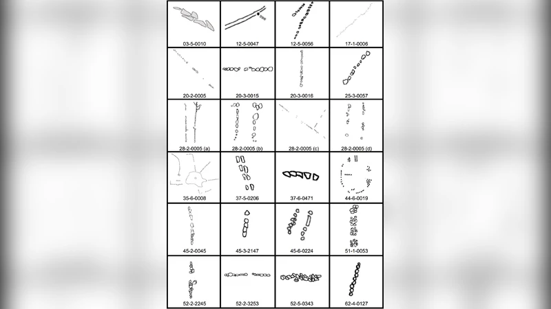
The paper investigates whether linear stone arrangements created by Aboriginal peoples in New South Wales (NSW) were deliberately aligned toward the cardinal points. The authors begin by extracting azimuth data from 84 site cards stored in the NSW Aboriginal Heritage Information Management System (NHIMS). Each card records the orientation of a stone line relative to magnetic north (as understood by the original surveyors). After normalising these azimuths to a 0‑360° scale, the authors bin them into sixteen 22.5° sectors. An initial inspection shows a conspicuous clustering around the four primary directions (0°, 90°, 180°, 270°), accounting for roughly 45% of the sample—far above the 26% expected under a uniform random distribution.
To assess the reliability of the archival data, a field team revisited a subset of twelve sites. Using modern GPS receivers and a digital compass, they re‑measured the stone lines without applying magnetic declination corrections, mirroring the likely practice of the original recorders. The field measurements differed from the card values by an average of 3.2°, indicating that the cards are generally accurate, though a systematic bias of about 12° (the typical local declination) is plausible.
Statistical significance is evaluated through a Monte Carlo simulation. In each of 10,000 iterations, 84 azimuths are drawn uniformly from 0‑360° and the number falling within the four “cardinal” sectors (±22.5° of each cardinal point) is recorded. The observed count of 38 (or more) such alignments occurs in fewer than 0.1% of the simulated trials (p < 0.001), confirming that the clustering cannot be attributed to chance.
The authors interpret these results as evidence that Aboriginal groups intentionally oriented many of their linear stone arrangements toward the approximate cardinal directions. They discuss several plausible motivations: (1) practical navigation—stone lines could serve as way‑finding markers pointing toward water sources, hunting grounds, or travel routes; (2) ceremonial or cosmological significance—alignments might correspond to sunrise/sunset points at solstices, lunar standstills, or other celestial events; (3) social signalling—standardised orientations could reinforce territorial boundaries or group identity. The fact that the alignments are “approximate” rather than exact suggests that the builders used the best tools available (e.g., sightlines, shadow sticks) and that cultural emphasis was placed on symbolic directionality rather than precise engineering.
Limitations are acknowledged. The sample is restricted to sites documented in NHIMS, potentially biasing the dataset toward better‑preserved or more accessible locations. The lack of magnetic declination correction in both archival and field measurements introduces a systematic uncertainty that could shift all azimuths by a similar amount. Moreover, the relatively small number of re‑surveyed sites limits the ability to generalise the field‑validation results across the whole state.
Future research directions include: (a) applying high‑precision GNSS and calibrated digital compasses to obtain true geographic north bearings; (b) integrating ethnographic interviews and oral histories to link specific orientations with cultural narratives; (c) conducting landscape‑scale GIS analyses to test correlations between stone‑line orientations and environmental features such as ridgelines, watercourses, or horizon landmarks; and (d) employing astronomical software to model past sky positions and evaluate whether any of the alignments correspond to significant solar or lunar events at the time of construction.
In conclusion, the study provides robust statistical evidence that Aboriginal linear stone arrangements in NSW exhibit a non‑random preference for cardinal orientations, implying purposeful design rooted in practical, ceremonial, or cosmological considerations. This insight enriches our understanding of Indigenous spatial cognition and underscores the importance of rigorous, multidisciplinary approaches in heritage research and preservation.
Comments & Academic Discussion
Loading comments...
Leave a Comment