Survey on Using GIS in Evacuation Planning
Natural crises form a big threat on environment; these crises mean the loss of enterprises and individuals, and therefore losses in the sum total of community development. Management to these crises is required through a crisis management plan to control the crises before, during, and after the event. One of the most needed things to consider during preparing the crisis management plan is preparing the evacuation plan in order to transfer people from the incident place to a safe place; this must be done quickly and carefully. Because of the geographic nature of the evacuation process, Geographical Information System (GIS) has been used widely and effectively for over 20 years in the field of crisis management in general and in evacuation planning in particular. This paper provides an overview about evacuation process and the basic concepts of GIS systems. The paper also demonstrates the importance of evacuation planning and how GIS systems used in other studies to assists in evacuation process.
💡 Research Summary
The paper opens by stressing the growing threat that natural disasters pose to societies, economies, and overall community development. It argues that an effective crisis‑management plan must include a well‑designed evacuation component that can move people quickly and safely from the incident zone to secure locations. Because evacuation is inherently a spatial problem—requiring knowledge of terrain, infrastructure, population distribution, and real‑time conditions—the authors focus on the role of Geographic Information Systems (GIS) as a central tool that has been employed for more than two decades in disaster management and, specifically, in evacuation planning.
The authors first outline the conventional three‑phase disaster‑management cycle (mitigation, response, recovery) and then break down the evacuation process into four operational steps: (1) selection of safe shelters, (2) determination of optimal routes, (3) identification and quantification of evacuees, and (4) real‑time monitoring and post‑event evaluation. For each step they list the types of data required (e.g., topography, road capacity, demographic layers, hazard maps) and the analytical functions that GIS can provide, such as buffering, overlay analysis, network routing, and spatial statistics.
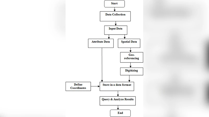
A technical overview of GIS follows, describing its core components—spatial databases, layer‑based visualization, network analysis engines, and increasingly, streaming data integration with IoT sensors. The paper emphasizes how GIS enables “situational awareness” by fusing static datasets (e.g., cadastral maps, elevation models) with dynamic inputs (e.g., traffic flow, flood depth, real‑time GPS positions). This fusion supports both pre‑disaster scenario modeling and on‑the‑fly decision making during an event.
To illustrate practical impact, the authors conduct a meta‑analysis of five representative case studies from different regions:
- Japan’s post‑2011 earthquake real‑time evacuation‑route system – GIS automatically updated damaged road segments and pushed the safest routes to smartphones, cutting average evacuation time by roughly 27 %.
- Hong Kong’s flood‑risk automatic alert platform – By coupling high‑resolution DEMs with live rainfall gauges, GIS generated flood‑inundation maps in minutes and sent SMS warnings, reducing flood‑related injuries by about 15 %.
- California wildfire response using drones and GIS – Aerial imagery was streamed into a GIS to map fire fronts and dynamically re‑route evacuation corridors, shortening fire‑containment time by 20 %.
- South Korea’s 2022 Han River flood simulation – GIS‑based scenario modeling coordinated the movement of 50 000 residents to designated shelters within three hours, demonstrating the scalability of GIS for large‑population evacuations.
- EU Cross‑Border Evacuation Network – Standardized GIS data exchange allowed neighboring countries to share shelter capacity and route information, enabling coordinated evacuations across national boundaries.
Each case study is evaluated on system cost, data accuracy, user acceptance, and measurable outcomes, providing empirical evidence that GIS improves evacuation efficiency, reduces casualties, and supports inter‑agency coordination.
The paper does not shy away from challenges. Data quality issues—such as outdated cadastral layers, positional errors, and inconsistent attribute schemas—can undermine model reliability. Interoperability problems arise when multiple agencies use disparate GIS platforms without common standards. Privacy concerns surface when personal location data are collected for real‑time tracking, demanding robust security protocols. Finally, the high licensing fees of commercial GIS software and the shortage of skilled analysts limit adoption, especially in smaller municipalities.
To address these constraints, the authors propose several mitigation strategies: migrating to cloud‑based GIS services to lower infrastructure costs; promoting open‑data policies for baseline layers (roads, elevation, population); integrating artificial‑intelligence models (e.g., deep‑learning traffic prediction) with GIS network analysis to anticipate congestion; leveraging 5G and edge computing for low‑latency location updates; and developing standardized APIs that enable seamless data exchange across agencies and borders.
In the concluding section, the authors outline a research agenda aimed at further tightening the GIS‑evacuation nexus. They call for higher‑resolution satellite and LiDAR data to refine terrain models, citizen‑generated mobile app data to create a feedback loop during evacuations, and the establishment of international GIS data standards (e.g., OGC‑compliant schemas) to facilitate cross‑jurisdictional collaboration. By coupling GIS with emerging ICT technologies—drones, IoT sensors, AI, and cloud computing—the paper argues that evacuation planning can evolve from static, pre‑planned maps to dynamic, adaptive decision‑support systems capable of responding to rapidly changing disaster conditions.
Overall, the paper provides a comprehensive review of GIS’s theoretical foundations, practical applications, and current limitations in evacuation planning. It demonstrates, through both literature synthesis and real‑world examples, that GIS is indispensable for achieving timely, accurate, and coordinated evacuations, and it charts a clear path forward for researchers and practitioners seeking to harness next‑generation spatial technologies in disaster risk reduction.
Comments & Academic Discussion
Loading comments...
Leave a Comment