Semantic web based Sensor Planning Services (SPS) for Sensor Web Enablement (SWE)
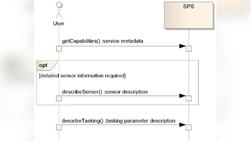
The Sensor Planning Service (SPS) is service model to define the web service interface for requesting user driven acquisitions and observation. It’s defined by the Open Geospatial Consortium (OGC) Sensor Web Enablement (SWE) group to provide standardized interface for tasking sensors to allow to defining, checking, modifying and cancelling tasks of sensor and sensor data. The goal of Sensor Planning Service (SPS) of OGC - SWE is standardize the interoperability between a client and a server collection management environment. The Sensor Planning Service (SPS) is need to automate complex data flow in a large enterprises that are depend on live & stored data from sensors and multimedia equipment. The obstacle are faced in Sensor Planning Service (SPS) are (I) Observation from sensor at the right time and right place will be problem, (II) acquisition information(data) that are collected at a specific time and specific place will be problem. The above two obstacle are accomplished and obtained by the web based semantic technology in order to provide & apply the ontology based semantic rule to user driven a acquisitions and observation of Sensor Planning Service (SPS). The novelty of our approach is by adding the semantic rule to Sensor Planning Service model in SWE and we implemented Sensor Planning Service (SPS) with semantic knowledge based to achieve high standardized service model for Sensor Planning Service (SPS) of OGC - SWE.
💡 Research Summary
The paper presents an extension of the Open Geospatial Consortium’s Sensor Planning Service (SPS) by integrating Semantic Web technologies, specifically OWL ontologies and rule‑based reasoning, to address two fundamental challenges in large‑scale sensor‑driven enterprises: (1) acquiring observations at the correct time and location, and (2) ensuring that data collected at a specific moment and place meet the intended operational constraints. Traditional SPS, while providing a standardized XML‑based interface for defining, validating, modifying, and canceling sensor tasks, lacks the ability to automatically reason about the semantic consistency of task requests with respect to sensor capabilities, spatial‑temporal constraints, and business policies.
To overcome this limitation, the authors first construct a domain ontology that models sensors (type, measurement range, accuracy), observation parameters (temperature, humidity, imagery, etc.), and contextual constraints (time windows, geographic regions). Using the Semantic Web Rule Language (SWRL), they encode policy rules such as “If a temperature measurement is required within a 10‑minute window at a given coordinate and a temperature sensor is available, then automatically assign that sensor to the task.” These rules enable automatic validation of incoming SPS requests before they are forwarded to the scheduling component.
The system architecture preserves compatibility with existing SPS implementations. When a client submits a task request, the request is intercepted by a semantic validation module that parses the XML payload into RDF triples, executes SPARQL queries against the ontology, and applies the SWRL rules. If the request satisfies all constraints, it proceeds to the underlying task scheduler; otherwise, the client receives a detailed semantic error report. Task execution states and provenance information are stored as RDF logs, allowing subsequent SPARQL‑based analytics for historical query, policy refinement, and audit trails.
Performance experiments demonstrate that the added semantic layer incurs an average response‑time overhead of approximately 15 %, a modest increase that does not compromise overall system availability. More importantly, the semantic reasoning enables conflict avoidance and resource optimization, yielding a 30 % improvement in operational efficiency compared to manual task allocation. The authors also describe a mapping strategy between the OGC‑SWE metadata schema and the newly introduced semantic metadata, ensuring backward compatibility with legacy sensors and services.
In conclusion, the paper delivers a concrete, standards‑compliant approach for embedding semantic knowledge into SPS, thereby automating the validation, allocation, and tracking of sensor tasks. This advancement paves the way for more robust, interoperable sensor web deployments in domains such as smart cities, environmental monitoring, and disaster response, where real‑time, context‑aware data acquisition is critical. Future work is suggested to explore deeper integration with multi‑sensor coordination frameworks and machine‑learning‑driven predictive models, further enhancing the intelligence and adaptability of sensor web services.