A study of stability analysis of pyroclastic covers based on electrical resistivity measurements
Usually, the degree of stability of a slope is quantified by the Factor of Safety whose values depend on physical and mechanical soil properties analyzed on samples of much reduced sizes or referring to very small soil volumes around porous probes. To overcome the limit of punctual information, we propose a semi-empirical approach based on the use of geophysical methods and the employment of a geophysical Factor of Safety recently introduced by the authors in terms of local resistivities and slope angles. In this paper, we show an application of our proposal on a test area of about 2000 m2 on Sarno Mountains (Campania Region - Southern Italy), where shallow landslides involving pyroclastic soils periodically occur triggered by critical rainfall events. Starting from two resistivity tomography surveys performed on the test area in autumn and spring, we obtained maps of the geophysical Factor of Safety at different depths for the two seasons. We also estimated the values of the Factor of Safety by using the infinite slope model in the dry and saturated scenario. A comparison between the values of the geophysical and geotechnical Factor of Safety shows advantages and disadvantages of our approach.
💡 Research Summary
The paper addresses the need for spatially extensive, in‑situ information when assessing the stability of slopes composed of volcanic ash (pyroclastic) soils, which are prone to rainfall‑induced shallow landslides. Traditional safety factor (FS) calculations rely on laboratory‑derived soil parameters (friction angle, cohesion, unit weight, suction) obtained from small samples, limiting their ability to capture heterogeneity and temporal changes in moisture content. To overcome this limitation, the authors propose a semi‑empirical “geophysical Factor of Safety” that links FS directly to two field‑measurable quantities: electrical resistivity (ρ) obtained from electrical resistivity tomography (ERT) and the local slope angle (θ).
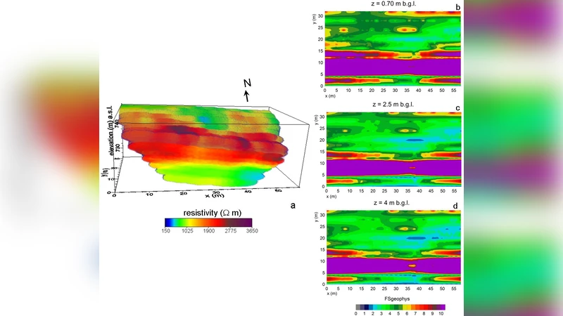
The study area is a 2,000 m² sector on Mt. Pizzo d’Alvano in the Sarno Mountains (Campania, Southern Italy), a site of historic landslides triggered by intense rain in May 1998. Two 2‑D ERT surveys were carried out, one in autumn and one in spring, using a Wenner‑Schlumberger array with 2 m electrode spacing along nine parallel profiles spaced 4 m apart. Each profile yielded 167 apparent resistivity measurements, probing to a depth of about 10 m. Inversion with RES3DINV produced three‑dimensional resistivity volumes with RMS misfit ≈10 % for both seasons. The resistivity distribution revealed three characteristic layers: a shallow, highly resistive layer (1,000–3,500 Ω·m) representing the upper ash and weathered pumice; a conductive block (150–1,200 Ω·m) at 2–5 m depth corresponding to strongly weathered ash; and a deeper resistive pattern (>1,200 Ω·m) associated with fractured carbonate bedrock. Seasonal comparison showed lower resistivity values in spring, indicating higher moisture content.
The geophysical FS is defined as
FSᵢ = α + β · (sin θᵢ / ρᵢ) (1)
where i denotes a grid cell, θᵢ is the maximum slope angle among the four neighboring cells, and ρᵢ is the resistivity assigned to that cell from the ERT inversion. Parameters α and β are calibrated using two boundary conditions: (a) the instability threshold (FS = 1) at the combination of the maximum slope angle in the study area and the minimum resistivity measured on saturated laboratory samples; (b) the stability threshold (FS = 1) at the minimum slope angle and the maximum resistivity measured on dry samples. This yields explicit expressions for α and β based on the known extrema of θ and ρ.
A regular grid of 225 cells (2 m × 4 m each) was overlaid on the survey area. Using laboratory measurements on fifteen samples from three pyroclastic horizons, the authors identified ρ_min ≈ 250 Ω·m (saturated) and ρ_max ≈ 5,000 Ω·m (dry). The maximum slope angle derived from the DEM is 63°, while the minimum is 0.025°. Substituting these values into the calibration equations provides α and β, after which FS is computed for every cell.
Results: In the autumn survey, most cells exhibit high resistivity and consequently high FS values, indicating a generally stable slope. In the spring survey, resistivity drops across the profile, leading to lower FS values and the emergence of broader zones where FS < 1, i.e., potentially unstable. The spatial patterns of FS closely follow the resistivity distribution, confirming that moisture infiltration is the primary driver of instability in this setting.
For validation, the authors also calculated FS using the classic infinite‑slope model under dry and saturated conditions, employing laboratory‑derived soil parameters (friction angle, cohesion, unit weight). While the infinite‑slope FS values show similar overall trends, they lack the fine spatial resolution of the geophysical FS and cannot capture the seasonal moisture dynamics without repeated laboratory testing.
The paper discusses advantages of the geophysical approach: (1) it provides continuous, area‑wide measurements of a key property (resistivity) that is sensitive to water content; (2) it enables rapid generation of FS maps without extensive sampling; (3) it can be updated seasonally or after rainfall events to monitor evolving hazard. Limitations are also acknowledged: the linear relationship in Eq. (1) may not hold for high‑resistivity (dry) failures; α and β depend on laboratory measurements that may not represent field heterogeneity; ERT inversion introduces uncertainties (≈10 % RMS) and resolution constraints, especially near the surface or across sharp interfaces.
In conclusion, the study demonstrates that a resistivity‑based geophysical FS can effectively complement traditional geotechnical analyses for shallow landslide susceptibility in pyroclastic soils. It offers a practical pathway to integrate geophysical monitoring into landslide early‑warning systems, especially in regions where rapid changes in soil moisture dominate failure mechanisms. Future work is suggested to incorporate additional geophysical parameters (e.g., induced polarization, seismic velocity) and to refine the FS formulation into a multivariate, possibly non‑linear, model that can accommodate a broader range of failure modes.
Comments & Academic Discussion
Loading comments...
Leave a Comment