3D Terrestrial lidar data classification of complex natural scenes using a multi-scale dimensionality criterion: applications in geomorphology
3D point clouds of natural environments relevant to problems in geomorphology often require classification of the data into elementary relevant classes. A typical example is the separation of riparian vegetation from ground in fluvial environments, the distinction between fresh surfaces and rockfall in cliff environments, or more generally the classification of surfaces according to their morphology. Natural surfaces are heterogeneous and their distinctive properties are seldom defined at a unique scale, prompting the use of multi-scale criteria to achieve a high degree of classification success. We have thus defined a multi-scale measure of the point cloud dimensionality around each point, which characterizes the local 3D organization. We can thus monitor how the local cloud geometry behaves across scales. We present the technique and illustrate its efficiency in separating riparian vegetation from ground and classifying a mountain stream as vegetation, rock, gravel or water surface. In these two cases, separating the vegetation from ground or other classes achieve accuracy larger than 98 %. Comparison with a single scale approach shows the superiority of the multi-scale analysis in enhancing class separability and spatial resolution. The technique is robust to missing data, shadow zones and changes in point density within the scene. The classification is fast and accurate and can account for some degree of intra-class morphological variability such as different vegetation types. A probabilistic confidence in the classification result is given at each point, allowing the user to remove the points for which the classification is uncertain. The process can be both fully automated, but also fully customized by the user including a graphical definition of the classifiers. Although developed for fully 3D data, the method can be readily applied to 2.5D airborne lidar data.
💡 Research Summary
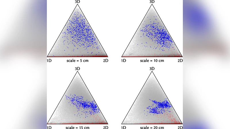
The paper presents a novel method for automatically classifying terrestrial laser‑scanning (TLS) point clouds of complex natural environments. Recognizing that natural surfaces exhibit heterogeneous geometry across a wide range of spatial scales, the authors introduce a “multi‑scale dimensionality” feature that quantifies the local 1‑D, 2‑D, or 3‑D character of the point cloud around each point. For a given point, a spherical neighborhood of diameter s is defined; a Principal Component Analysis (PCA) of the points inside the sphere yields three eigenvalues λ₁ ≥ λ₂ ≥ λ₃. The normalized eigenvalue proportions pᵢ = λᵢ/(λ₁+λ₂+λ₃) are plotted in a ternary diagram, where a point near a vertex indicates a predominantly linear (1‑D) structure, near an edge a planar (2‑D) structure, and near the centre a volumetric (3‑D) structure. By computing this descriptor at several scales (e.g., 1 cm, 5 cm, 30 cm), each point acquires a multi‑scale “dimensionality signature”.
During training, a small set of manually labeled points is used to discover which combination of scales best separates the desired classes. The selected scales feed conventional classifiers (e.g., LDA, SVM), which output both a class label and a probabilistic confidence for each point. The authors implemented the workflow in a software suite called CANUPO, which can process millions of points on a standard laptop within minutes and offers both fully automated batch processing and an interactive graphical mode for user‑guided refinement.
The method was evaluated on two field sites. The first, a salt‑marsh in Mont‑Saint‑Michel (France), involved a simple binary classification of riparian vegetation versus sandy ground. The second, a steep mountain‑river gorge in Otira (New Zealand), required distinguishing four classes: vegetation, bedrock, gravels, and water surface. In both cases the overall classification accuracy exceeded 98 %, with vegetation‑ground separation reaching 99.6 %. Compared with a single‑scale approach, the multi‑scale analysis improved class separability, spatial resolution, and robustness to variable point density, shadows, and missing data. Because the descriptor relies solely on geometry, it is independent of sensor‑specific intensity or RGB information, allowing classifiers trained on one instrument to be reused on data from another.
Key advantages include: (1) scale‑adaptive handling of heterogeneous features; (2) insensitivity to point‑density fluctuations and occlusion; (3) fast processing suitable for large datasets; (4) provision of per‑point confidence to filter uncertain results; and (5) ease of integration into automated pipelines. Limitations noted are potential distortion for extremely thin objects (e.g., single leaves) and the presence of mixed‑point noise at object boundaries, which can be mitigated by post‑processing filters or by incorporating such cases into the training set.
In conclusion, the multi‑scale dimensionality criterion offers a robust, intuitive, and mathematically sound solution for classifying complex natural TLS data, outperforming traditional single‑scale or intensity‑based methods. Future work will explore real‑time extensions, fusion with radiometric attributes, and application to even more intricate terrains such as caves or stratified soils.
Comments & Academic Discussion
Loading comments...
Leave a Comment