Airborne Geophysical Surveys in the North-Central Region of Goias (Brazil): Implications for Radiometric Characterization of Subtropical Soils
In this work we present progress obtained in analysis airborne geophysical survey data for the north-central region of the state of Goias (Brazil). The results obtained indicate that most of the subtropical soil types are characterized by Uranium contents of greater than one parts per million (ppm). Only ultisol and oxisol soils are found to have Uranium contents lower than one ppm. Thorium and Potassium abundances also display trends similar to those of Uranium. The K/U ratios fall in the expected range of values for common soils while the Th/U ratios are higher than normal. This latter observation may indicate a characteristic feature of subtropical soils. Alternatively it may be considered as indicative of disequilibrium conditions in radioactive series and consequent underestimation of Uranium in soil layers of the study area. In this context we point out the possibility of using results of radiometric surveys as a convenient complementary tool in identifying geochemical zoning of soils in subtropical environments. Analysis of aeromagnetic data reveals the presence of a large number of magnetic lineaments. The analytic signal values point to the existence of substantial small scale variations related to lithologic changes. There are indications that deposition of soil types are controlled to a large extent by the system of NE-SW trending faults and fracture systems. According to results of radiogenic heat production calculations the cambisol soil in this region are found to have a mean heat production of 3.32 \pm 5.9 \mu Wm-3 while that of ultisol soil is only 0.36 \pm 0.3 \mu Wm-3. The mean heat production of soil layers at the surface is 0.68 \pm 0.4 \mu Wm-3. Heat production values of basement rocks are estimated to be more than 1.3 \muWm-3, after corrections for density changes and non-equilibrium conditions of Uranium series.
💡 Research Summary
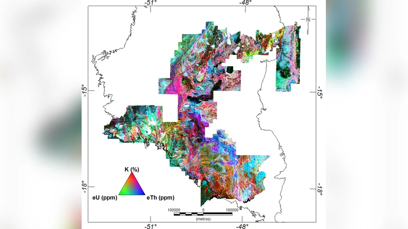
This study presents a comprehensive analysis of airborne gamma‑spectrometric and aeromagnetic data acquired over the north‑central region of the state of Goiás, Brazil, with the aim of characterizing the radiometric properties of subtropical soils and elucidating the structural controls on soil distribution and radiogenic heat production. The authors processed raw survey data using Geosoft Oasis Montaj, applying corrections for lag, heading, altitude, diurnal magnetic variations, and micro‑leveling. Interpolation was performed on a 125 m grid using Minimum Curvature for magnetic data and bicubic splines for radiometric data, ensuring compliance with Nyquist criteria. Sensor‑specific sensitivity coefficients (derived from IAEA 1991 guidelines) were employed to convert counts per second to elemental concentrations (U and Th in ppm, K in %).
Radiometric results reveal a regional mean uranium concentration of 1.28 ± 1.06 ppm, thorium of 11.4 ± 8.5 ppm, and potassium of 1.2 ± 0.8 %. The Th/U ratio is unusually high (≈ 8–10), far exceeding typical crustal values (≈ 3–4). The authors discuss two plausible explanations: (1) a genuine geochemical signature of subtropical soils, possibly related to acidic, highly weathered conditions that preferentially leach uranium; and (2) disequilibrium in the uranium decay series, which would cause under‑estimation of uranium in gamma‑spectrometric measurements. The latter hypothesis is supported by the large standard deviations and the spatial correlation of low uranium with Ultisol and Oxisol soils.
Soil‑type specific analyses (Table 2) show that Cambisol, Plintosol, Entisol, Gleisol, and Nitisol possess higher U (≈ 1.2–1.5 ppm) and Th (≈ 10–12 ppm) than Ultisol and Oxisol (U ≈ 0.6–0.8 ppm, Th ≈ 5–6 ppm). Potassium follows a similar trend, except for Plintosol, which exhibits a relatively low K content, possibly reflecting fertilizer use or mineralogical differences. These patterns suggest that the conventional Brazilian soil classification, which relies primarily on physical‑chemical criteria, is relatively insensitive to radiometric variations, and that airborne radiometry could serve as a complementary tool for geochemical zoning.
Aeromagnetic interpretation identifies two dominant lineament sets: a southeast‑to‑northwest (SE‑NW) trend prevalent in the southern and northeastern sectors, and a southwest‑to‑northeast (SW‑NE) trend dominant in the northern and western sectors. The SE‑NW lineaments are interpreted as younger, post‑Precambrian structures, whereas the SW‑NE trend aligns with the known SW‑NE trending Precambrian fault system of the region. Analytic signal amplitudes range from –0.9 to 45 nT m⁻¹, with higher values in the western and central parts, indicating significant magnetic susceptibility contrasts at shallow depths, likely associated with intrusive bodies or highly magnetized lithologies. These structural features appear to exert a strong control on the spatial distribution of soil types, as evidenced by the alignment of certain soil boundaries with major lineaments.
Radiogenic heat production was calculated using standard heat production coefficients (U = 0.95 µW kg⁻¹ ppm, Th = 0.26 µW kg⁻¹ ppm, K = 0.036 µW kg⁻¹ %). Density corrections (≈ 2.2 g cm⁻³) and adjustments for possible uranium disequilibrium were applied. The resulting mean heat production values are 3.32 ± 5.9 µW m⁻³ for Cambisol, 0.36 ± 0.3 µW m⁻³ for Ultisol, and 0.68 ± 0.4 µW m⁻³ for the overall surface layer. Basement rocks are estimated to generate > 1.3 µW m⁻³ after density and disequilibrium corrections. These figures highlight the strong variability of heat flow potential within a relatively small geographic area and underscore the importance of integrating radiometric data into regional geothermal models.
In conclusion, the paper demonstrates that airborne geophysical surveys provide valuable, high‑resolution information on both the radiometric composition of subtropical soils and the underlying structural framework that controls their distribution. The elevated Th/U ratios and the correlation of low‑U soils with specific pedogenic classes suggest either a distinctive geochemical signature of the region or a pervasive disequilibrium in the uranium decay series. The identified magnetic lineaments and analytic‑signal anomalies point to a complex fault network that likely influences soil development, drainage, and heat production. The authors recommend further ground‑based sampling, isotopic disequilibrium studies, and integration with other geophysical datasets (e.g., electromagnetic, gravity) to refine the interpretation and to develop more robust models for soil classification, resource exploration, and geothermal assessment in subtropical environments.
Comments & Academic Discussion
Loading comments...
Leave a Comment