Applying Advanced Spaceborne Thermal Emission and Reflection Radiometer (ASTER) spectral indices for geological mapping and mineral identification on the Tibetan Plateau
The Tibetan Plateau holds clues to understanding the dynamics and mechanisms associated with continental growth. Part of the region is characterized by zones of ophiolitic melange believed to represent the remnants of ancient oceanic crust and underlying upper mantle emplaced during oceanic closures. However, due to the remoteness of the region and the inhospitable terrain many areas have not received detailed investigation. Increased spatial and spectral resolution of satellite sensors have made it possible to map in greater detail the mineralogy and lithology than in the past. Recent work by Yoshiki Ninomiya of the Geological Survey of Japan has pioneered the use of several spectral indices for the mapping of quartzose, carbonate, and silicate rocks using Advanced Spaceborne Thermal Emission and Reflection Radiometer (ASTER) thermal infrared (TIR) data. In this study, ASTER TIR indices have been applied to a region in western-central Tibet for the purposes of assessing their effectiveness for differentiating ophiolites and other lithologies. The results agree well with existing geological maps and other published data. The study area was chosen due to its diverse range of rock types, including an ophiolitic melange, associated with the Bangong-Nujiang suture (BNS) that crops out on the northern shores of Lagkor Tso and Dong Tso (“Tso” is Tibetan for lake). The techniques highlighted in this paper could be applied to other geographical regions where similar geological questions need to be resolved. The results of this study aim to show the utility of ASTER TIR imagery for geological mapping in semi-arid and sparsely vegetated areas on the Tibetan Plateau.
💡 Research Summary
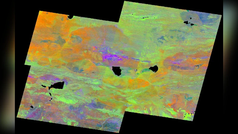
This study evaluates the utility of Advanced Spaceborne Thermal Emission and Reflection Radiometer (ASTER) thermal infrared (TIR) data for geological mapping on the Tibetan Plateau, focusing on the discrimination of ophiolitic mélanges and surrounding lithologies. Building on the spectral index methodology pioneered by Yoshiki Ninomiya, three indices are defined: the Quartz Index (QI) that highlights quartz‑rich rocks by exploiting higher emissivity in band 11 relative to bands 10 and 12; the Carbonate Index (CI) that isolates carbonate minerals through the contrast between bands 13 and 14, with a temperature‑normalization step to mitigate surface‑temperature effects; and the Mafic Index (MI) that differentiates mafic to ultramafic rocks using the ratio of bands 12 and 13, incorporating a separation factor (n) to reduce carbonate interference.
ASTER Level‑1B scenes acquired between 2000 and 2004 during winter months were screened for cloud cover (<2 %), converted from digital numbers to at‑sensor radiance using unit conversion coefficients, and band 13 radiance was normalized to a fixed 300 K black‑body temperature. The indices were applied to the normalized radiance to produce grayscale maps, which were then combined into false‑color composite images, contrast‑stretched, and mosaicked to generate the final geological map.
Comparison with existing geological maps and limited field observations demonstrates that QI successfully delineates quartz‑bearing sedimentary units, CI accurately maps carbonate lake margins, and MI effectively isolates the serpentinized, gabbroic, and peridotitic components of the Lagkor and Dong Tso ophiolitic mélanges. The results confirm that ASTER TIR, with its 90 m spatial resolution, can provide reliable lithological discrimination in semi‑arid, sparsely vegetated high‑altitude terrains.
The authors acknowledge limitations, including the lack of atmospheric correction (which particularly affects CI) and potential index overlap in complex lithological assemblages. Future work is suggested to incorporate atmospheric correction, integrate VNIR/SWIR data, and explore machine‑learning classification to enhance mapping precision. Overall, the paper demonstrates that ASTER TIR spectral indices constitute a cost‑effective, scalable tool for regional geological investigations on the Tibetan Plateau and comparable environments.
Comments & Academic Discussion
Loading comments...
Leave a Comment