Abusir: from Pliny the Elder to Google Maps
Abusir, the House of Osiris, is the name given to an Egyptian necropolis of the Old Kingdom period. This site is a part of a huge area, from Giza to Dahshur, rich of archaeological remains and covered by many pyramids. The paper is reporting concisely some archaeological studies on Abusir. We start from the description given by Pliny the Elder and end proposing the use of Google Maps.
💡 Research Summary
The paper “Abusir: from Pliny the Elder to Google Maps” offers a concise yet comprehensive overview of archaeological research on the Abusir necropolis, tracing the intellectual trajectory from the earliest literary mention by the Roman author Pliny the Elder to the application of modern satellite‑based mapping tools. The authors begin by examining Pliny’s passage in Naturalis Historia, where he describes a “great region of pyramids” called Abusir that contains the tombs of kings and nobles. Although Pliny’s account is valuable as the first Western textual reference to the site, his description is imprecise: the “great pyramids” he mentions actually correspond to the modest, later‑Old Kingdom pyramids and associated rectangular mastabas rather than the massive Giza pyramids. By juxtaposing Pliny’s narrative with archaeological evidence, the authors demonstrate how early literary sources can both illuminate and obscure the physical reality of ancient landscapes.
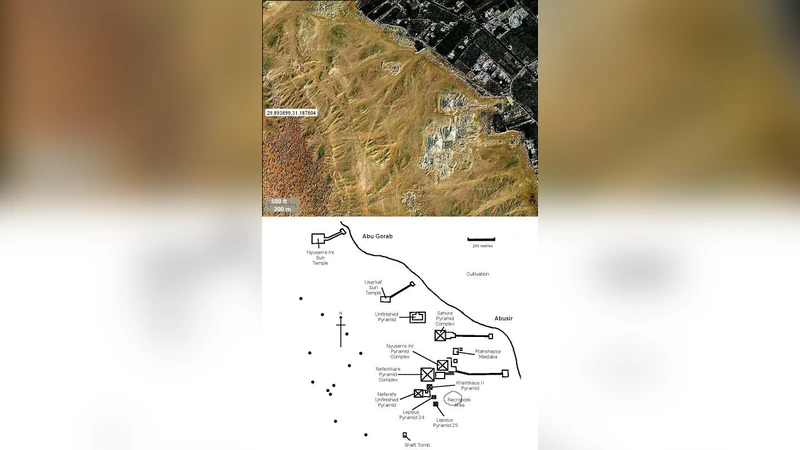
The second part of the paper reviews the history of field investigations carried out from the late 19th century through the early 20th century. Pioneering scholars such as Leonardo Baur and Marcel Bart documented that Abusir is not primarily a royal temple complex but a dense burial ground for high‑ranking officials of the Fifth Dynasty. Notable structures include the tombs of Pharaohs such as Sheti I and Neferirkare, which exhibit a hybrid architectural program: small pyramidal cores surrounded by extensive rectangular chambers, offering insight into the intertwining of religious, administrative, and funerary functions during the late Old Kingdom. These traditional excavations established a baseline corpus of architectural typologies, stratigraphic sequences, and artifact assemblages that remain essential for any further interpretation of the site.
The core contribution of the paper lies in its presentation of a digital methodology that leverages Google Maps, Google Earth Engine, and Geographic Information Systems (GIS) to augment conventional archaeology. High‑resolution satellite imagery and three‑dimensional digital elevation models (DEMs) are processed to detect subtle topographic anomalies that may indicate buried structures. The authors describe a workflow that integrates shadow‑analysis, spectral band combinations, and the Normalized Difference Vegetation Index (NDVI) to map variations in soil moisture and vegetation health—indirect proxies for sub‑surface architecture. By automating the identification of “potential tomb zones,” the approach dramatically reduces the time and manpower required for preliminary surveys across the expansive Abusir landscape.
The paper outlines several advantages of this remote‑sensing strategy. First, it enables rapid, cost‑effective reconnaissance of large areas that have not yet been excavated, thereby prioritizing fieldwork and allocating resources more efficiently. Second, it provides a visual cross‑check against legacy excavation maps, enhancing the objectivity of interpretive models. Third, temporal analysis of satellite data can flag modern threats—urban encroachment, agricultural expansion, or illicit looting—by revealing recent changes in land cover, allowing heritage managers to intervene before irreversible damage occurs. However, the authors also acknowledge limitations: the spatial resolution of publicly available imagery may be insufficient to detect deeply buried features, and environmental factors such as seasonal vegetation can generate false positives. Consequently, they argue that satellite‑based surveys should complement, not replace, ground‑truthing and systematic excavation.
In conclusion, the study positions Pliny’s ancient description as a foundational textual anchor, while demonstrating that contemporary GIS and remote‑sensing technologies can build a high‑resolution, dynamic model of the Abusir necropolis. The integration of literary sources, traditional field data, and modern digital tools offers a more nuanced understanding of Old Kingdom funerary practices and provides a scalable framework for the preservation and management of Egypt’s vast archaeological heritage.
Comments & Academic Discussion
Loading comments...
Leave a Comment