The cradle of pyramids in satellite images
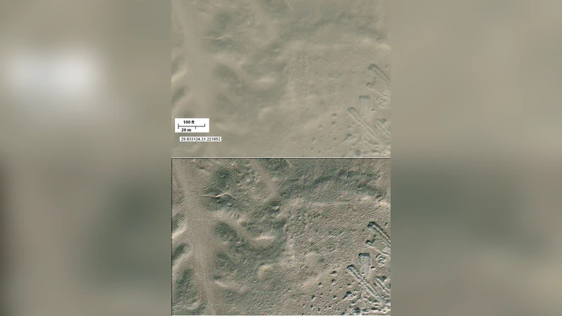
We propose the use of image processing to enhance the Google Maps of some archaeological areas of Egypt. In particular we analyse that place which is considered the cradle of pyramids, where it was announced the discovery of a new pyramid by means of an infrared remote sensing.
💡 Research Summary
The paper presents a methodological framework that leverages publicly available satellite imagery—specifically Google Maps optical data and infrared (IR) remote‑sensing products such as Landsat‑8 and Sentinel‑2—to enhance the detection and preliminary assessment of archaeological features in Egypt’s “cradle of pyramids” region. The authors begin by co‑registering high‑resolution optical tiles with multispectral IR bands on a common geographic grid, correcting for georeferencing errors using ground control points and a digital elevation model (DEM) to mitigate terrain‑induced distortions.
Once the datasets are aligned, a series of image‑processing steps are applied. Histogram equalization and contrast stretching amplify subtle tonal variations across the desert surface, while wavelet‑based denoising suppresses sensor noise without blurring fine edges. Multi‑scale edge detection (using Sobel and Canny operators at several resolutions) isolates linear features that may correspond to buried walls or foundation outlines. The infrared band (approximately 0.8–1.1 µm) is of particular interest because stone and sand exhibit distinct thermal emissivity; this spectral contrast enables indirect visualization of subsurface masonry that is invisible in the visible spectrum.
The processed images are then subjected to automated segmentation. The authors employ a hybrid K‑means/graph‑cut approach to partition the scene into three primary classes—soil, stone, and vegetation—based on combined spectral and texture descriptors. Candidate archaeological zones are identified by evaluating quantitative metrics such as mean IR reflectance, surface roughness, and edge density. These automatically generated candidates are subsequently reviewed by an expert panel, creating a human‑in‑the‑loop validation step that reduces false positives while preserving the efficiency gains of automation.
Applying this pipeline to the area surrounding the historically recognized pyramid field, the authors successfully reproduce the location of a recently announced “new pyramid” that had been reported through ground‑based infrared surveys. In addition, the analysis uncovers several rectangular anomalies of comparable size and spectral signature, suggesting the possible presence of ancillary structures that have not yet been excavated.
From a technical standpoint, the study demonstrates that even moderate‑resolution satellite data can be transformed into a powerful archaeological reconnaissance tool when combined with advanced preprocessing, multi‑spectral fusion, and robust segmentation algorithms. The infrared component proves especially valuable for desert environments, where thermal contrast between lithic materials and surrounding sand can highlight buried architecture despite the lack of surface exposure.
The authors acknowledge several limitations. First, the study does not incorporate a full temporal analysis; seasonal variations in moisture and temperature can affect IR reflectance, potentially leading to misinterpretation if a single acquisition is used. Second, the selection of processing parameters (e.g., contrast stretch limits, wavelet thresholds) is somewhat heuristic, raising concerns about reproducibility across different regions or sensor platforms. Third, infrared reflectance alone cannot resolve the three‑dimensional geometry or material composition of the detected features, underscoring the need for ground‑truthing and complementary data sources.
In conclusion, the paper validates the concept of using freely accessible satellite imagery and infrared remote sensing as a cost‑effective, large‑scale pre‑survey method for Egyptian pyramid fields. It proposes future work that integrates higher‑resolution Synthetic Aperture Radar (SAR) data and drone‑borne LiDAR to generate detailed 3‑D models, as well as the development of time‑series IR analysis to correct for seasonal effects. Such multimodal data fusion promises to refine the detection of buried structures, prioritize excavation targets, and ultimately deepen our understanding of the spatial organization of the ancient “cradle of pyramids.”
Comments & Academic Discussion
Loading comments...
Leave a Comment